Skip to content
MapSculpt

GEOGRAPHIC MAP MAKER / ALASKA

Alaska
Boroughs & Census Areas Map Maker

Map Alaska’s 30 official Census county equivalents, including boroughs, census areas, municipalities and city-and-borough units. Explore domestic migration in Anchorage and the surrounding boroughs.

Free online editor · No sign-up required

30county equivalents
individually editable

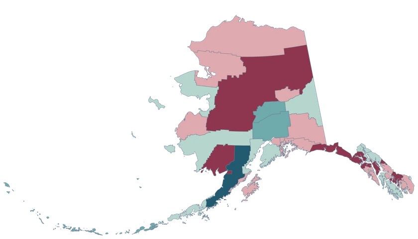
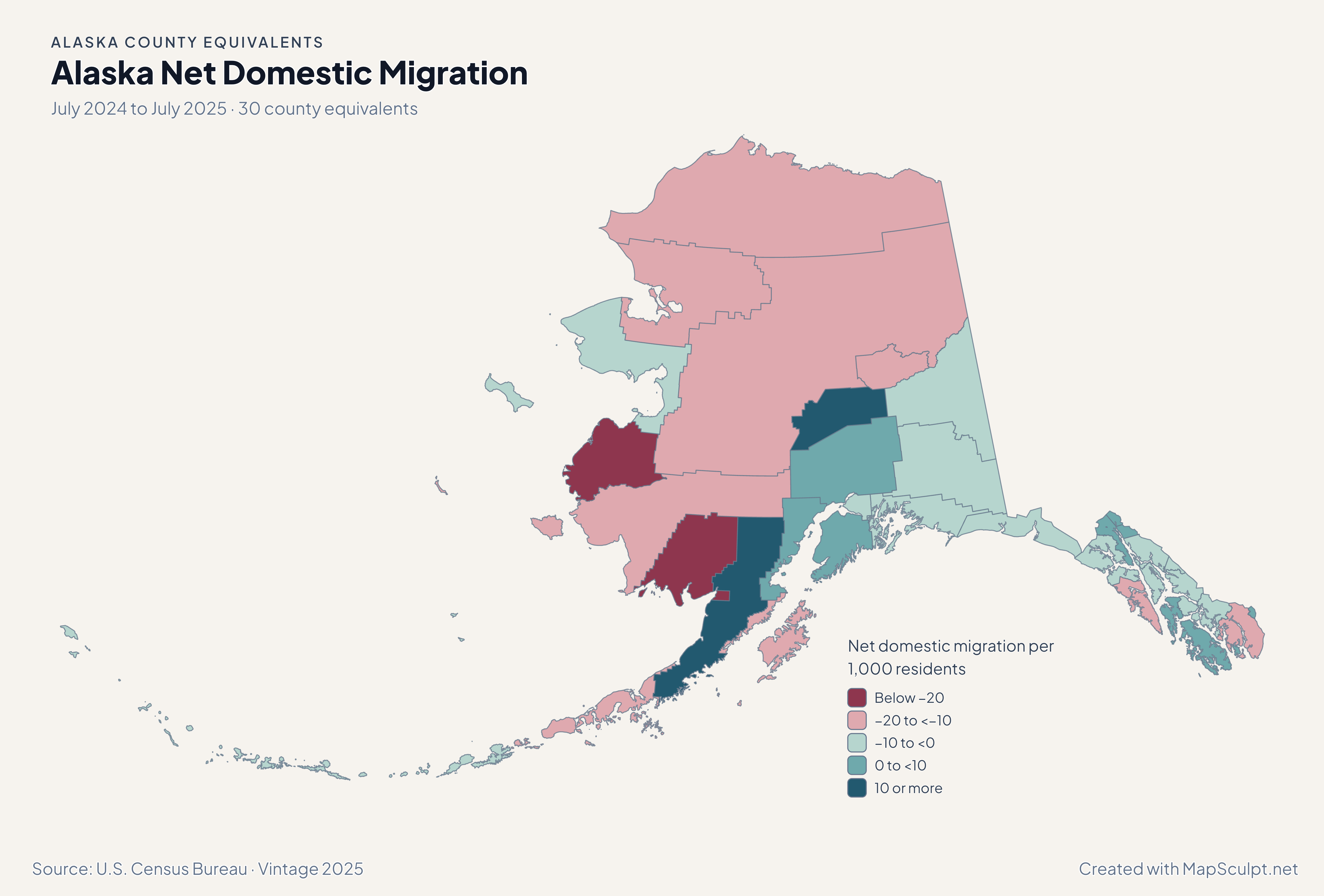
Alaska Net Domestic Migration

July 2024 to July 2025 · 30 county equivalents

Alaska net domestic migration map. Anchorage in a net domestic loss band and Matanuska-Susitna and Kenai Peninsula in a gain band.

Net domestic migration per 1,000 residents

  • Below −20
  • −20 to <−10
  • −10 to <0
  • 0 to <10
  • 10 or more
U.S. Census Bureau · Vintage 2025Download complete PNG Net domestic moves per 1,000 residents, using average July 2024 and July 2025 populations.

KNOW YOUR GEOGRAPHY

How Alaska reports county-level geography

The editor uses the existing Alaska Albers projection. It preserves the Aleutian chain, northern coastline and Southeast Alaska within the same statewide geography.

A Census county equivalent is a unit for reporting county-level statistics. The directory uses official names such as Anchorage Municipality, Juneau City and Borough, and Nome Census Area.

Browse all county equivalent GEOIDs ↗

2025 Census boundaries

OFFICIAL DATA

Domestic migration differed between Anchorage and nearby boroughs

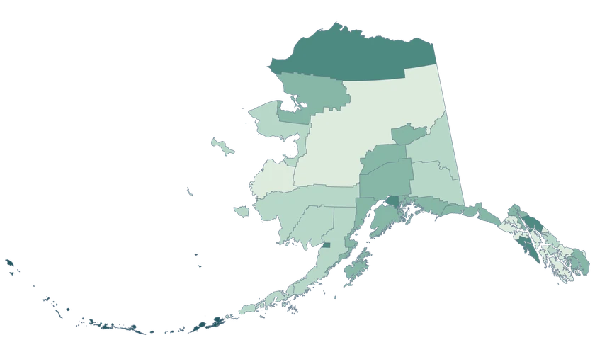
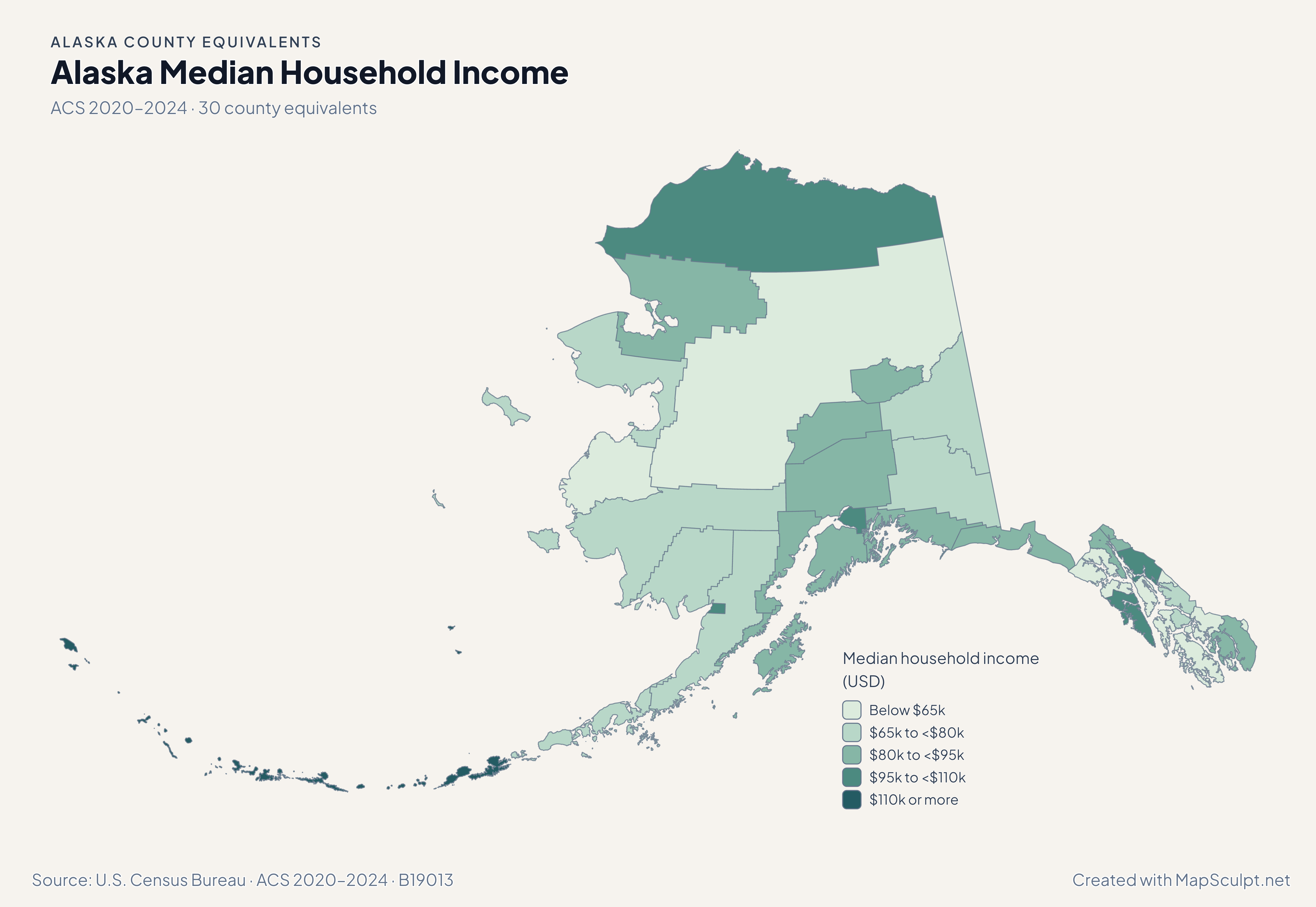
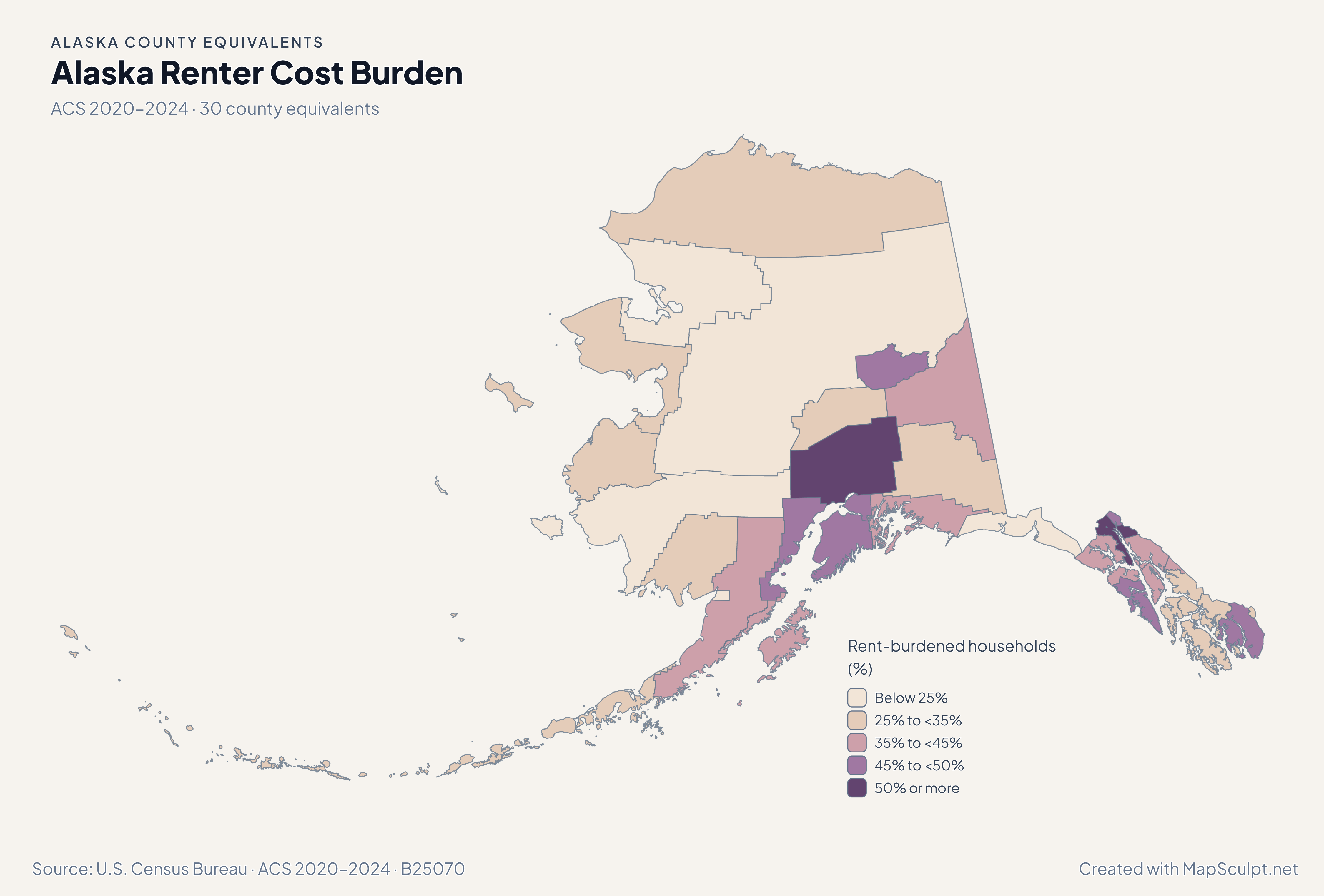
Use the four maps to compare July-to-July population estimates with the separate 2020–2024 ACS household estimates.

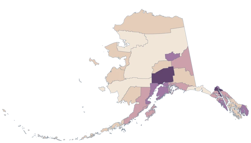
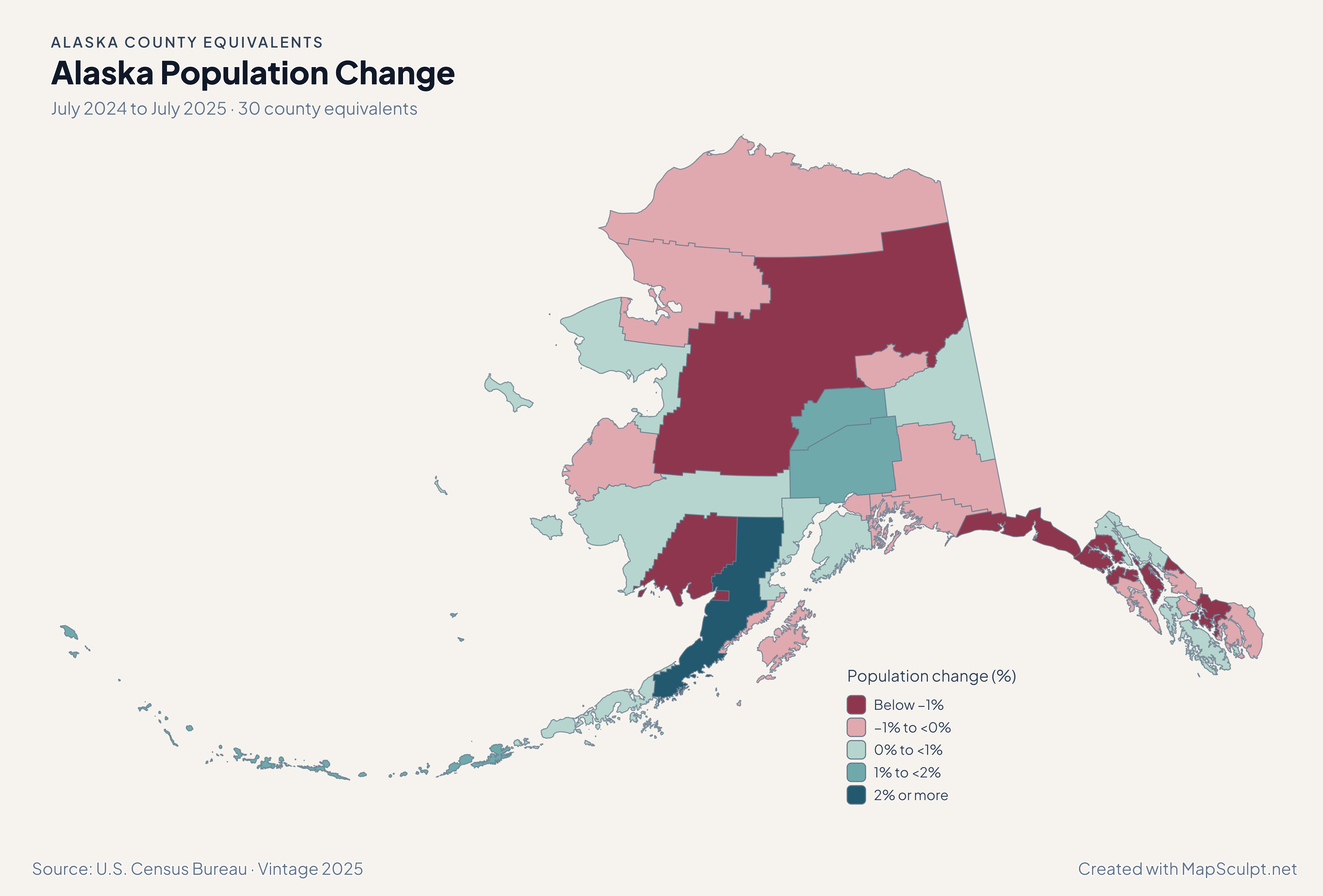
Alaska population change map. Growth bands for Matanuska-Susitna and Kenai Peninsula alongside a small loss band for Anchorage.

July 2024 to July 2025 · 30 county equivalents

Matanuska-Susitna and Kenai Peninsula gained population

Matanuska-Susitna Borough grew 1.20% and Kenai Peninsula Borough 0.82%. Anchorage Municipality declined 0.07% over the same July-to-July period.

Population change (%)

  • Below −1%
  • −1% to <0%
  • 0% to <1%
  • 1% to <2%
  • 2% or more

U.S. Census Bureau · Vintage 2025

Download complete PNG

Anchorage Municipality recorded −9.46 net domestic moves per 1,000 residents. Matanuska-Susitna Borough and Kenai Peninsula Borough recorded +7.49 and +6.01. A large rate in a small area can reflect relatively few moves. See the Census estimates ↗

MAKE IT YOURS

From county equivalent data to a finished map.

  1. Open the Alaska editor

    Start with all 30 county equivalents individually selectable.

  2. Match rows by GEOID

    Import a CSV using the five-character county equivalent GEOIDs from the directory.

  3. Style the county equivalents

    Set readable class labels and keep the neutral fill visible for unmatched areas.

  4. Export the annotated map

    Preview the full geography, legend and source before downloading a PNG.

TRY CSV IMPORT

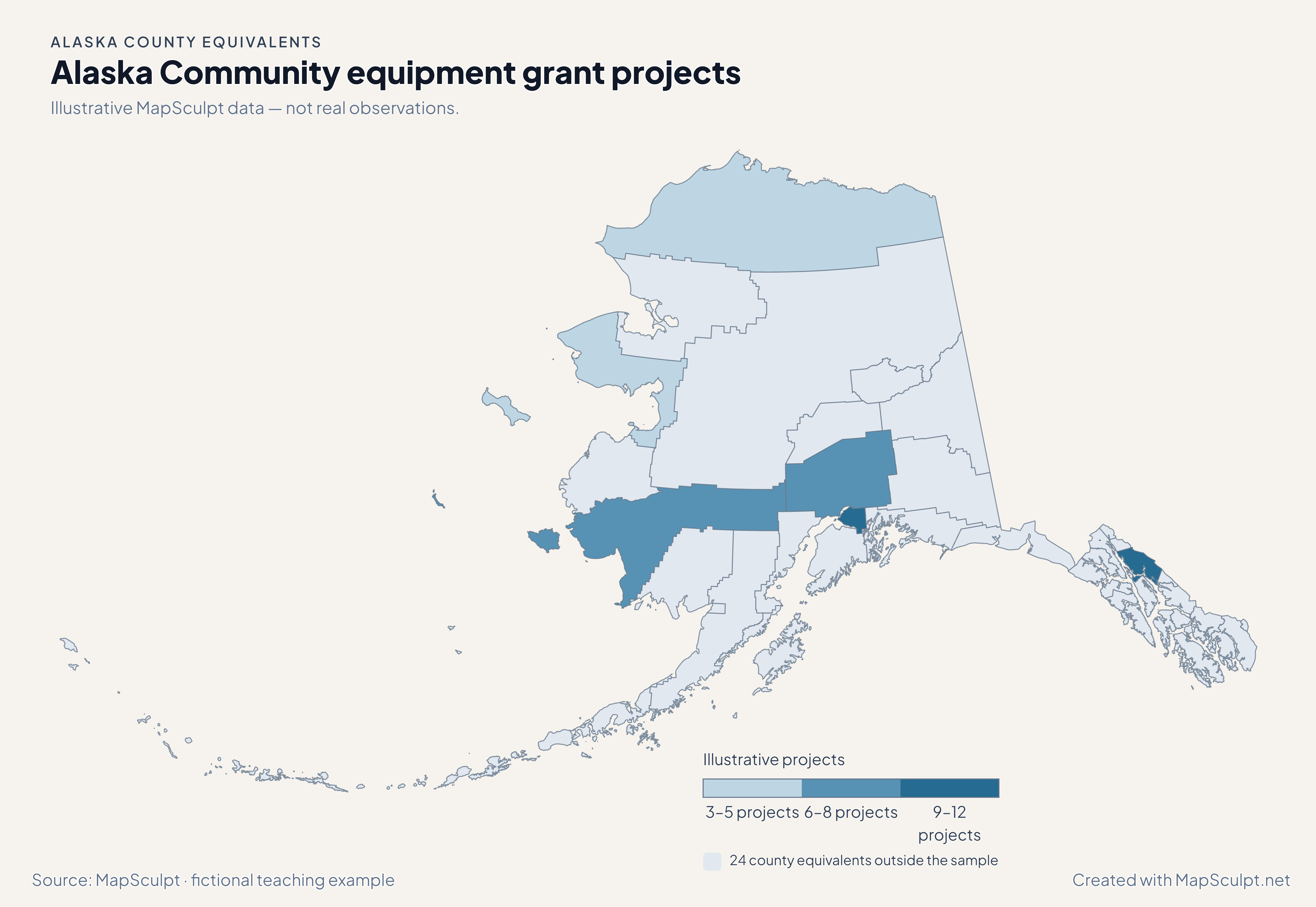
Community equipment grant projects in Alaska

Illustrative MapSculpt data — not real observations. The file joins 6 official GEOIDs and leaves 24 county equivalents neutral.

Illustrative MapSculpt data — not real observations.
County equivalentGEOIDProjects
Anchorage Municipality0202011
Matanuska-Susitna Borough021708
Juneau City and Borough021109
Nome Census Area021804
Bethel Census Area020506
North Slope Borough021853

Match on GEOID, select IllustrativeProjects, and enter custom boundaries 3, 6, 9 and 12.

Download illustrative CSV ↓

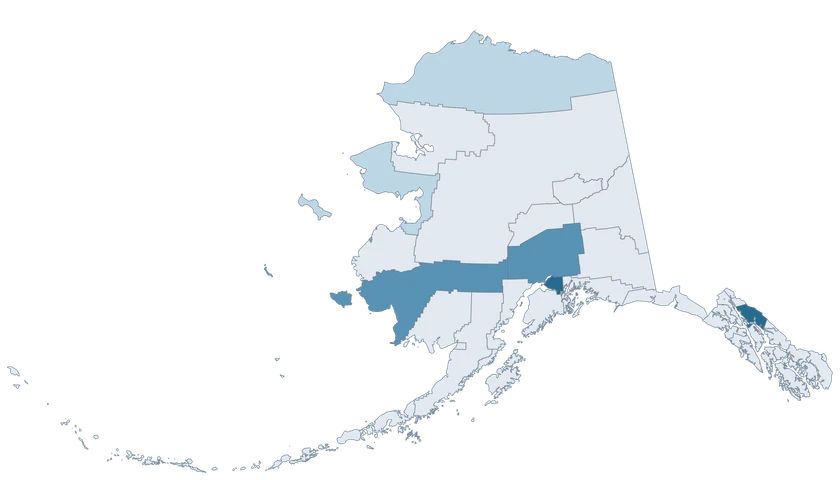
Alaska Community equipment grant projects

Illustrative MapSculpt data — not real observations.

Fictional Alaska community equipment grant projects map showing 6 sampled county equivalents with the rest neutral.

Illustrative projects

  • 3–5 projects
  • 6–8 projects
  • 9–12 projects
  • 24 county equivalents outside the sample
Download complete PNG

CSV → Match 6 county equivalents → Style → Export PNG Create a Alaska map

COUNTY EQUIVALENT REFERENCE

Find all 30 Alaska county equivalents and GEOIDs

Official county equivalent names and five-digit Census GEOIDs. Search by name or code.

  1. Aleutians East BoroughGEOID 02013
  2. Aleutians West Census AreaGEOID 02016
  3. Anchorage MunicipalityGEOID 02020
  4. Bethel Census AreaGEOID 02050
  5. Bristol Bay BoroughGEOID 02060
  6. Chugach Census AreaGEOID 02063
  7. Copper River Census AreaGEOID 02066
  8. Denali BoroughGEOID 02068
  9. Dillingham Census AreaGEOID 02070
  10. Fairbanks North Star BoroughGEOID 02090
  11. Haines BoroughGEOID 02100
  12. Hoonah-Angoon Census AreaGEOID 02105
  13. Juneau City and BoroughGEOID 02110
  14. Kenai Peninsula BoroughGEOID 02122
  15. Ketchikan Gateway BoroughGEOID 02130
  16. Kodiak Island BoroughGEOID 02150
  17. Kusilvak Census AreaGEOID 02158
  18. Lake and Peninsula BoroughGEOID 02164
  19. Matanuska-Susitna BoroughGEOID 02170
  20. Nome Census AreaGEOID 02180
  21. North Slope BoroughGEOID 02185
  22. Northwest Arctic BoroughGEOID 02188
  23. Petersburg BoroughGEOID 02195
  24. Prince of Wales-Hyder Census AreaGEOID 02198
  25. Sitka City and BoroughGEOID 02220
  26. Skagway MunicipalityGEOID 02230
  27. Southeast Fairbanks Census AreaGEOID 02240
  28. Wrangell City and BoroughGEOID 02275
  29. Yakutat City and BoroughGEOID 02282
  30. Yukon-Koyukuk Census AreaGEOID 02290
U.S. Census Bureau · 2025 Cartographic Boundary Files

COMMON QUESTIONS

Alaska county equivalent map questions.

How many county equivalents are in this Alaska map?

The editor contains 30 Census units. Each borough, census area, municipality or city and borough in the directory is individually selectable.

What GEOIDs should I use for Anchorage and Juneau?

Use 02020 for Anchorage Municipality and 02110 for Juneau City and Borough. Keep the leading zero when saving your CSV.

Can I color an Aleutian county equivalent with one row?

Yes. Match the official GEOID once to style the entire unit, including its multipart island geometry.

Where do I find Nome and Bethel in the directory?

Search Nome Census Area or GEOID 02180, and Bethel Census Area or GEOID 02050.

What does a high domestic migration rate mean in a small area?

It is a net count scaled to population. Check the absolute number of moves and the size of the population before comparing with Anchorage.

How do I keep Southeast Alaska and the Aleutians visible in an export?

Use a landscape frame and preview both ends of the statewide map with the legend included. The editor displays their existing projected positions.

YOUR NEXT MAP STARTS HERE

Build your own Alaska county-equivalent map

Use the official county equivalent shapes to highlight a local comparison, join your own rows, or export a map for a presentation.

Create a Alaska map