Skip to content
MapSculpt

GEOGRAPHIC MAP MAKER / KENTUCKY

Kentucky
Counties Map Maker

Compare household income estimates from Louisville’s neighboring counties to eastern Kentucky. Add population and migration for a second view of the same 120 boundaries.

Free online editor · No sign-up required

120counties
individually editable

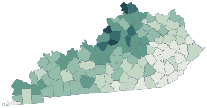
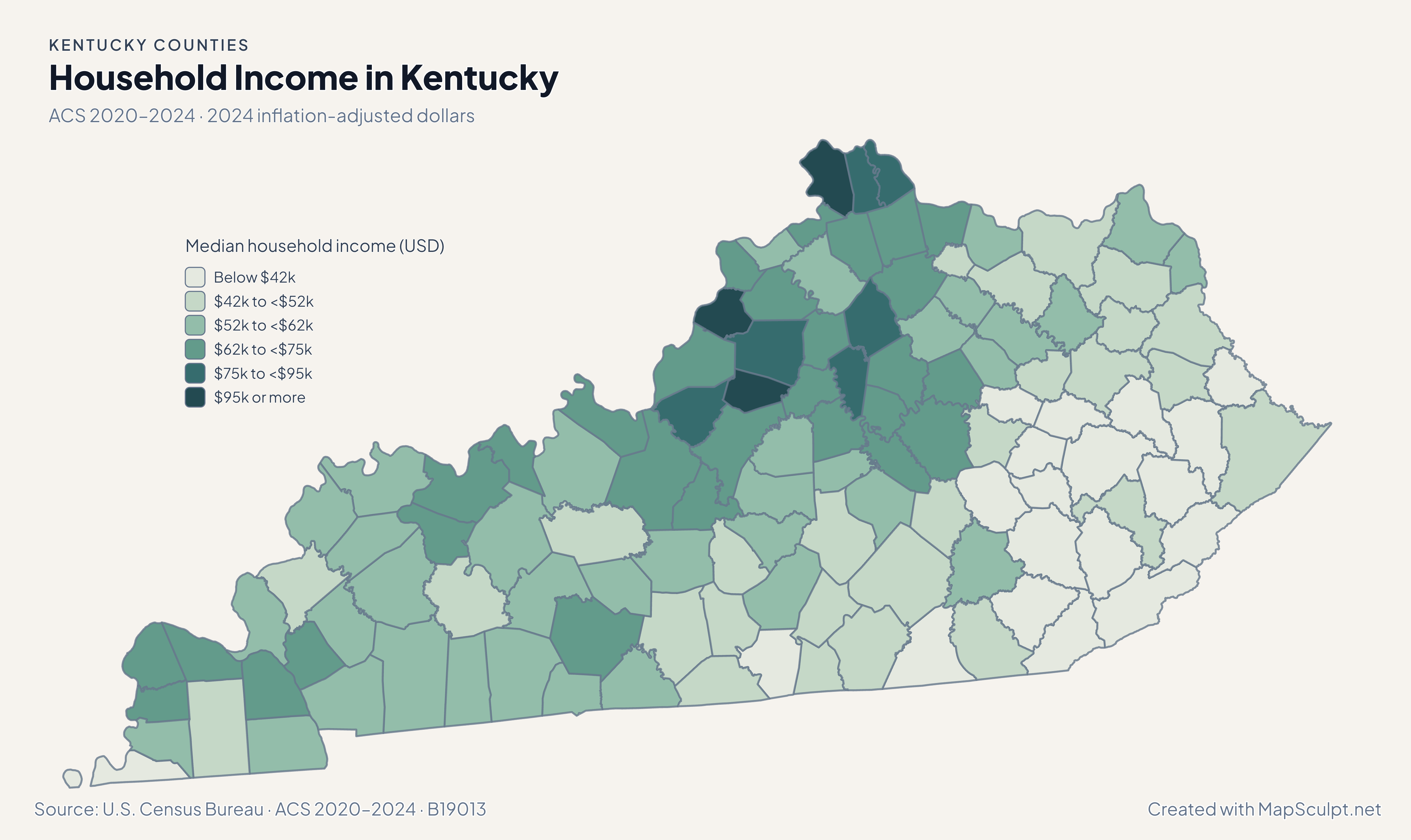
Household Income in Kentucky

ACS 2020–2024 · 2024 inflation-adjusted dollars

Kentucky household income, showing higher estimated medians around Oldham and lower estimates in several eastern counties.

Median household income (USD)

  • Below $42k
  • $42k to <$52k
  • $52k to <$62k
  • $62k to <$75k
  • $75k to <$95k
  • $95k or more
U.S. Census Bureau · ACS 2020–2024 · B19013Download complete PNG The ACS reports these household medians in 2024 inflation-adjusted dollars.

KNOW YOUR GEOGRAPHY

From the Ohio River to the Appalachian Plateau.

Kentucky’s county boundaries stretch from the western river counties across the Bluegrass to the Appalachian Plateau. All 120 Census county GEOIDs are selectable.

Louisville is associated with Jefferson County and Lexington with Fayette County. Use the county GEOID only when your dataset covers the whole county, especially for records labeled with a city name.

Browse all county GEOIDs ↗

2025 Census boundaries

OFFICIAL DATA

Household incomes and population shifts in Kentucky.

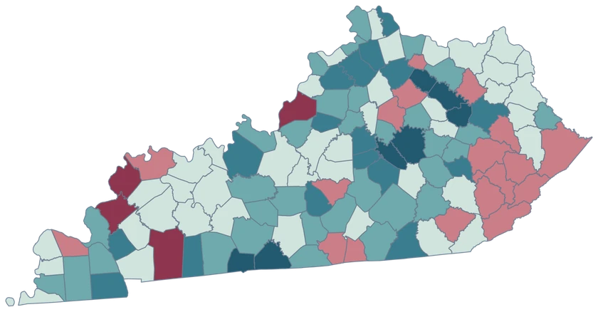
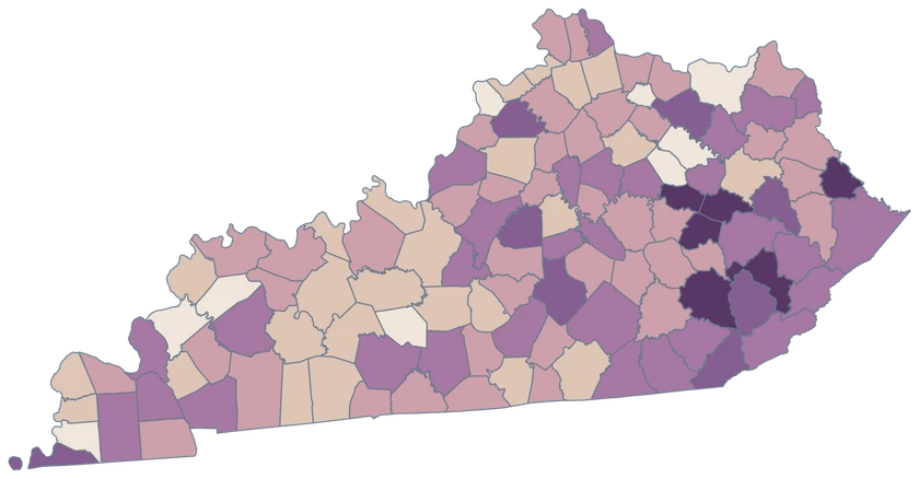
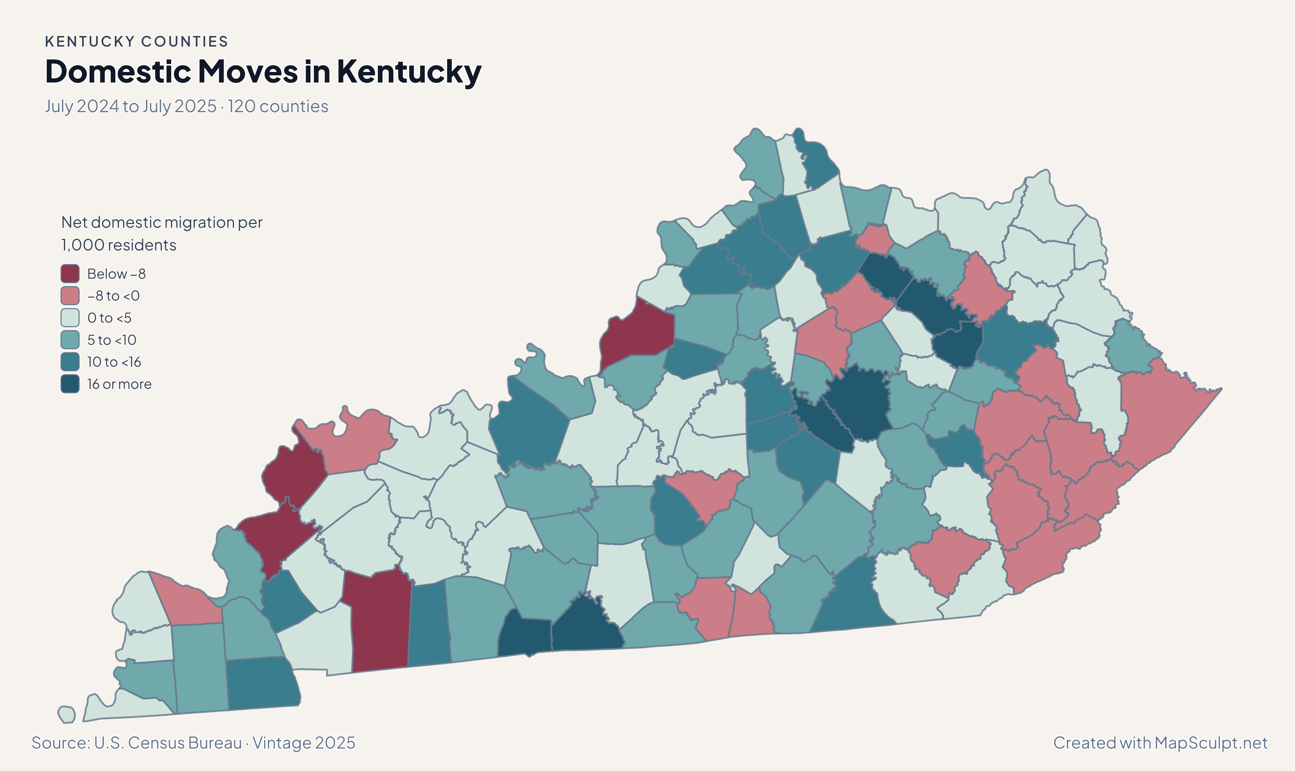
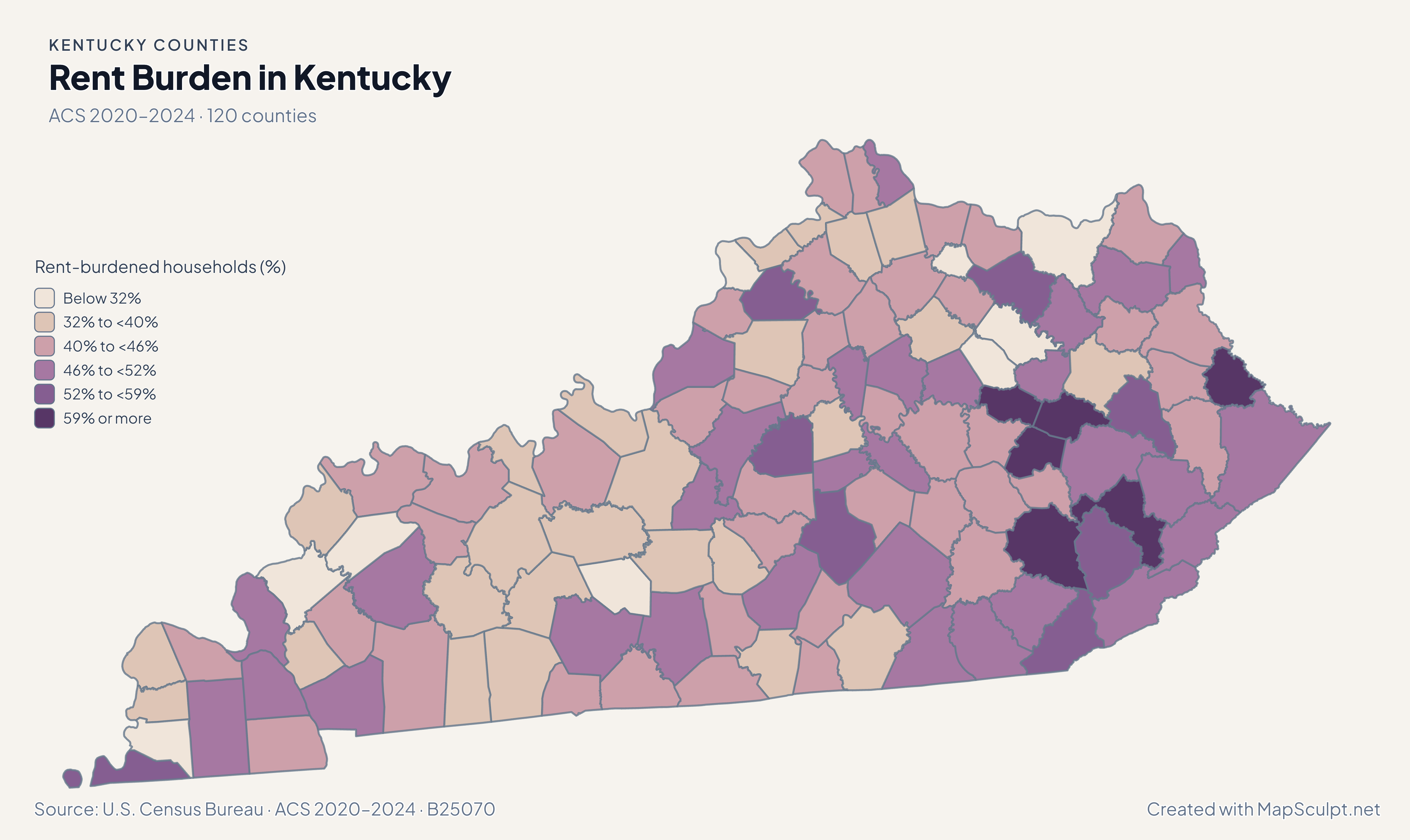
Population and domestic moves use the July 2024–July 2025 estimates. Income and renter costs use the 2020–2024 American Community Survey.

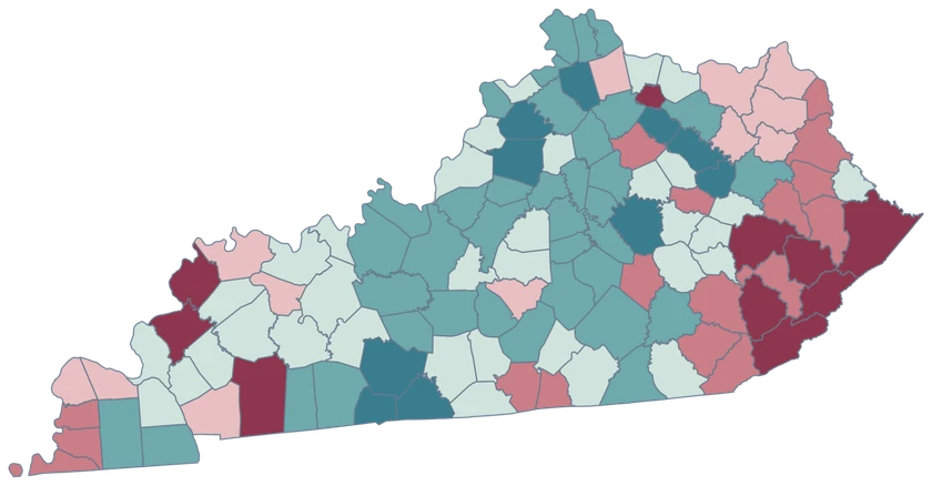
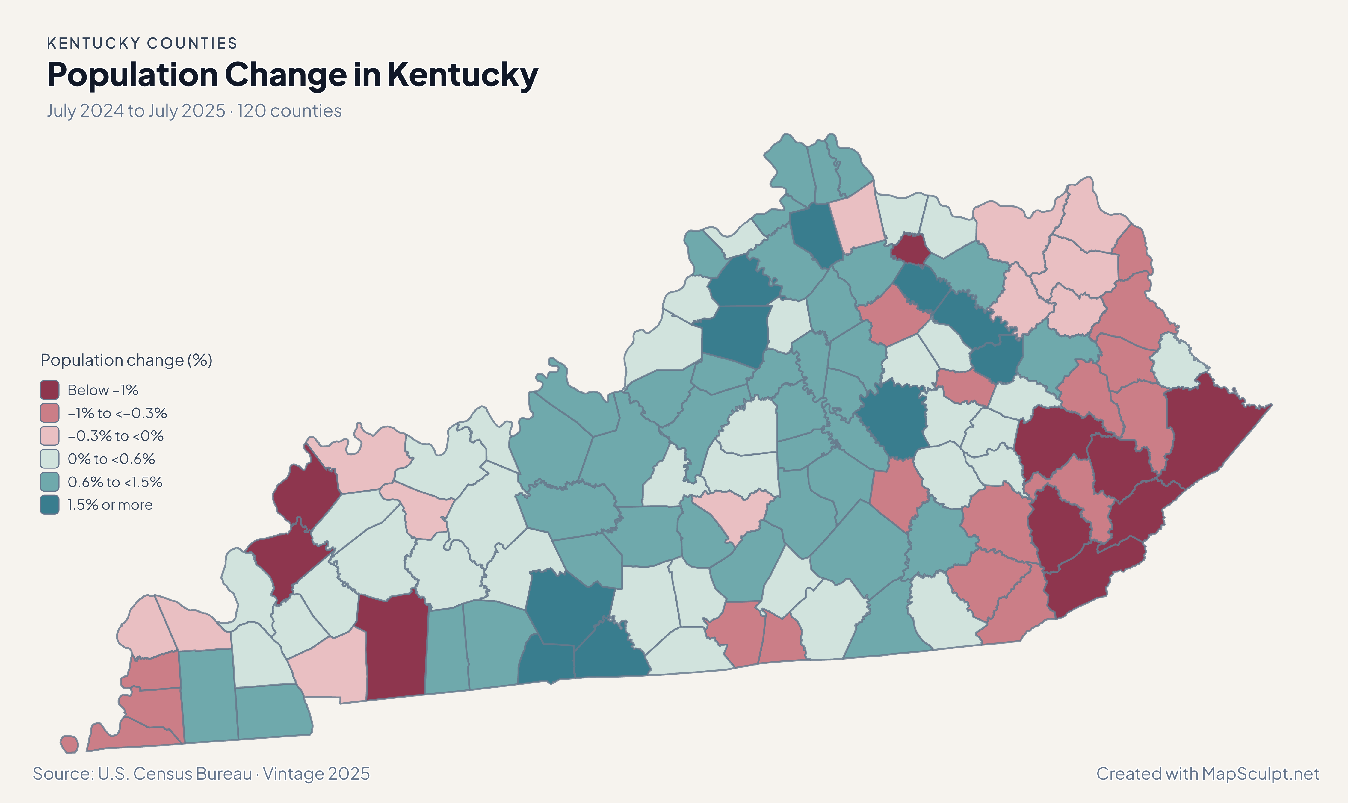
Kentucky population change, showing stronger growth in Madison and Warren than Fayette and Jefferson.

July 2024 to July 2025 · 120 counties

Madison grew faster than Fayette in the latest estimate.

From July 2024 to July 2025 Madison grew 2.10%, Fayette 0.82%, and Jefferson 0.13%. Warren, in south-central Kentucky, grew 1.92%.

Population change (%)

  • Below −1%
  • −1% to <−0.3%
  • −0.3% to <0%
  • 0% to <0.6%
  • 0.6% to <1.5%
  • 1.5% or more

U.S. Census Bureau · Vintage 2025

Download complete PNG

Oldham’s estimated household median was $122,497, compared with $69,866 in adjacent Jefferson and $44,312 in Pike, on the state’s eastern edge. The ACS estimates use 2024 dollars and carry sampling uncertainty. See the Census estimates ↗

MAKE IT YOURS

From county data to a finished map.

  1. Open the Kentucky editor

    Start with all 120 selectable counties.

  2. Match your county records

    Use 21111 for Jefferson County. Review the match list before applying colors.

  3. Choose a scale

    Use a palette and class boundaries suited to the units in your data.

  4. Export with a legend

    Include the source and reference period alongside a complete high-resolution PNG.

TRY CSV IMPORT

Try six Kentucky records.

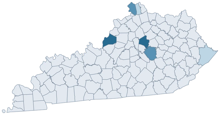
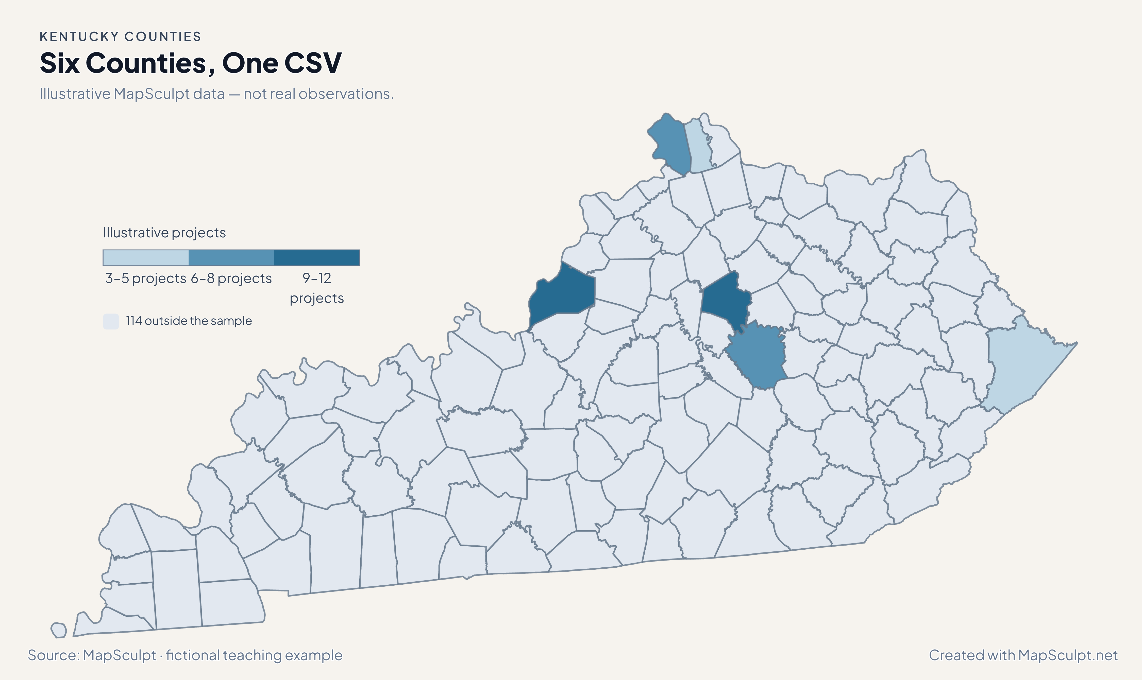
Import the fictional project counts and apply three custom classes. The other 114 counties stay neutral.

Illustrative MapSculpt data — not real observations.
CountyGEOIDProjects
Jefferson County2111112
Fayette County210679
Boone County210157
Kenton County211173
Madison County211518
Pike County211955

Keep five-digit GEOIDs as text. The sample uses 21111 for Jefferson County.

Download illustrative CSV ↓

Six Counties, One CSV

Illustrative MapSculpt data — not real observations.

Kentucky illustrative project counts for six counties; 114 counties remain neutral.

Illustrative projects

  • 3–5 projects
  • 6–8 projects
  • 9–12 projects
  • 114 outside the sample
Download complete PNG

CSV → Match 6 counties → Style → Export PNG Create a Kentucky map

COUNTY REFERENCE

All 120 Kentucky counties and GEOIDs.

Official county names and five-digit Census GEOIDs. Search by name or code.

  1. Adair CountyGEOID 21001
  2. Allen CountyGEOID 21003
  3. Anderson CountyGEOID 21005
  4. Ballard CountyGEOID 21007
  5. Barren CountyGEOID 21009
  6. Bath CountyGEOID 21011
  7. Bell CountyGEOID 21013
  8. Boone CountyGEOID 21015
  9. Bourbon CountyGEOID 21017
  10. Boyd CountyGEOID 21019
  11. Boyle CountyGEOID 21021
  12. Bracken CountyGEOID 21023
  13. Breathitt CountyGEOID 21025
  14. Breckinridge CountyGEOID 21027
  15. Bullitt CountyGEOID 21029
  16. Butler CountyGEOID 21031
  17. Caldwell CountyGEOID 21033
  18. Calloway CountyGEOID 21035
  19. Campbell CountyGEOID 21037
  20. Carlisle CountyGEOID 21039
  21. Carroll CountyGEOID 21041
  22. Carter CountyGEOID 21043
  23. Casey CountyGEOID 21045
  24. Christian CountyGEOID 21047
  25. Clark CountyGEOID 21049
  26. Clay CountyGEOID 21051
  27. Clinton CountyGEOID 21053
  28. Crittenden CountyGEOID 21055
  29. Cumberland CountyGEOID 21057
  30. Daviess CountyGEOID 21059
  31. Edmonson CountyGEOID 21061
  32. Elliott CountyGEOID 21063
  33. Estill CountyGEOID 21065
  34. Fayette CountyGEOID 21067
  35. Fleming CountyGEOID 21069
  36. Floyd CountyGEOID 21071
  37. Franklin CountyGEOID 21073
  38. Fulton CountyGEOID 21075
  39. Gallatin CountyGEOID 21077
  40. Garrard CountyGEOID 21079
  41. Grant CountyGEOID 21081
  42. Graves CountyGEOID 21083
  43. Grayson CountyGEOID 21085
  44. Green CountyGEOID 21087
  45. Greenup CountyGEOID 21089
  46. Hancock CountyGEOID 21091
  47. Hardin CountyGEOID 21093
  48. Harlan CountyGEOID 21095
  49. Harrison CountyGEOID 21097
  50. Hart CountyGEOID 21099
  51. Henderson CountyGEOID 21101
  52. Henry CountyGEOID 21103
  53. Hickman CountyGEOID 21105
  54. Hopkins CountyGEOID 21107
  55. Jackson CountyGEOID 21109
  56. Jefferson CountyGEOID 21111
  57. Jessamine CountyGEOID 21113
  58. Johnson CountyGEOID 21115
  59. Kenton CountyGEOID 21117
  60. Knott CountyGEOID 21119
  61. Knox CountyGEOID 21121
  62. Larue CountyGEOID 21123
  63. Laurel CountyGEOID 21125
  64. Lawrence CountyGEOID 21127
  65. Lee CountyGEOID 21129
  66. Leslie CountyGEOID 21131
  67. Letcher CountyGEOID 21133
  68. Lewis CountyGEOID 21135
  69. Lincoln CountyGEOID 21137
  70. Livingston CountyGEOID 21139
  71. Logan CountyGEOID 21141
  72. Lyon CountyGEOID 21143
  73. Madison CountyGEOID 21151
  74. Magoffin CountyGEOID 21153
  75. Marion CountyGEOID 21155
  76. Marshall CountyGEOID 21157
  77. Martin CountyGEOID 21159
  78. Mason CountyGEOID 21161
  79. McCracken CountyGEOID 21145
  80. McCreary CountyGEOID 21147
  81. McLean CountyGEOID 21149
  82. Meade CountyGEOID 21163
  83. Menifee CountyGEOID 21165
  84. Mercer CountyGEOID 21167
  85. Metcalfe CountyGEOID 21169
  86. Monroe CountyGEOID 21171
  87. Montgomery CountyGEOID 21173
  88. Morgan CountyGEOID 21175
  89. Muhlenberg CountyGEOID 21177
  90. Nelson CountyGEOID 21179
  91. Nicholas CountyGEOID 21181
  92. Ohio CountyGEOID 21183
  93. Oldham CountyGEOID 21185
  94. Owen CountyGEOID 21187
  95. Owsley CountyGEOID 21189
  96. Pendleton CountyGEOID 21191
  97. Perry CountyGEOID 21193
  98. Pike CountyGEOID 21195
  99. Powell CountyGEOID 21197
  100. Pulaski CountyGEOID 21199
  101. Robertson CountyGEOID 21201
  102. Rockcastle CountyGEOID 21203
  103. Rowan CountyGEOID 21205
  104. Russell CountyGEOID 21207
  105. Scott CountyGEOID 21209
  106. Shelby CountyGEOID 21211
  107. Simpson CountyGEOID 21213
  108. Spencer CountyGEOID 21215
  109. Taylor CountyGEOID 21217
  110. Todd CountyGEOID 21219
  111. Trigg CountyGEOID 21221
  112. Trimble CountyGEOID 21223
  113. Union CountyGEOID 21225
  114. Warren CountyGEOID 21227
  115. Washington CountyGEOID 21229
  116. Wayne CountyGEOID 21231
  117. Webster CountyGEOID 21233
  118. Whitley CountyGEOID 21235
  119. Wolfe CountyGEOID 21237
  120. Woodford CountyGEOID 21239

U.S. Census Bureau · 2025 Cartographic Boundary Files

COMMON QUESTIONS

Kentucky county map questions.

Is Louisville a separate county shape?

The county layer uses Jefferson County, GEOID 21111. Check your source when it uses Louisville or Louisville Metro as the geography.

What Census ID covers Fayette County?

Use 21067 for Fayette County. A tabulation for a Lexington neighborhood is more detailed than this map.

Can I map Northern Kentucky without adding Ohio counties?

Yes. Shade Boone, Kenton or Campbell separately in the Kentucky editor. Use the national county editor for cross-state comparisons.

How can I compare Appalachian counties?

Join values by county GEOID and document the counties used in your comparison. The map does not identify a separate Appalachian region.

Which period is used for household income?

The ACS pools survey responses across 2020–2024 and adjusts values to 2024 dollars. Use its margins of error for close comparisons.

Can I export thin county boundaries at higher resolution?

Use the complete PNG download or the editor’s high-resolution export. The on-page WebP is sized for browser viewing.

YOUR NEXT MAP STARTS HERE

Build your own Kentucky map.

Join your records by GEOID, check the counties that matched, and export with a legend and source.

Create a Kentucky map