Skip to content
MapSculpt

GEOGRAPHIC MAP MAKER / KANSAS

Kansas
Counties Map Maker

Compare Johnson and Wyandotte at the eastern border with Sedgwick and counties farther west. Build an editable Kansas map using all 105 county GEOIDs.

Free online editor · No sign-up required

105counties
individually editable

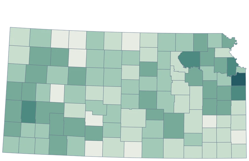
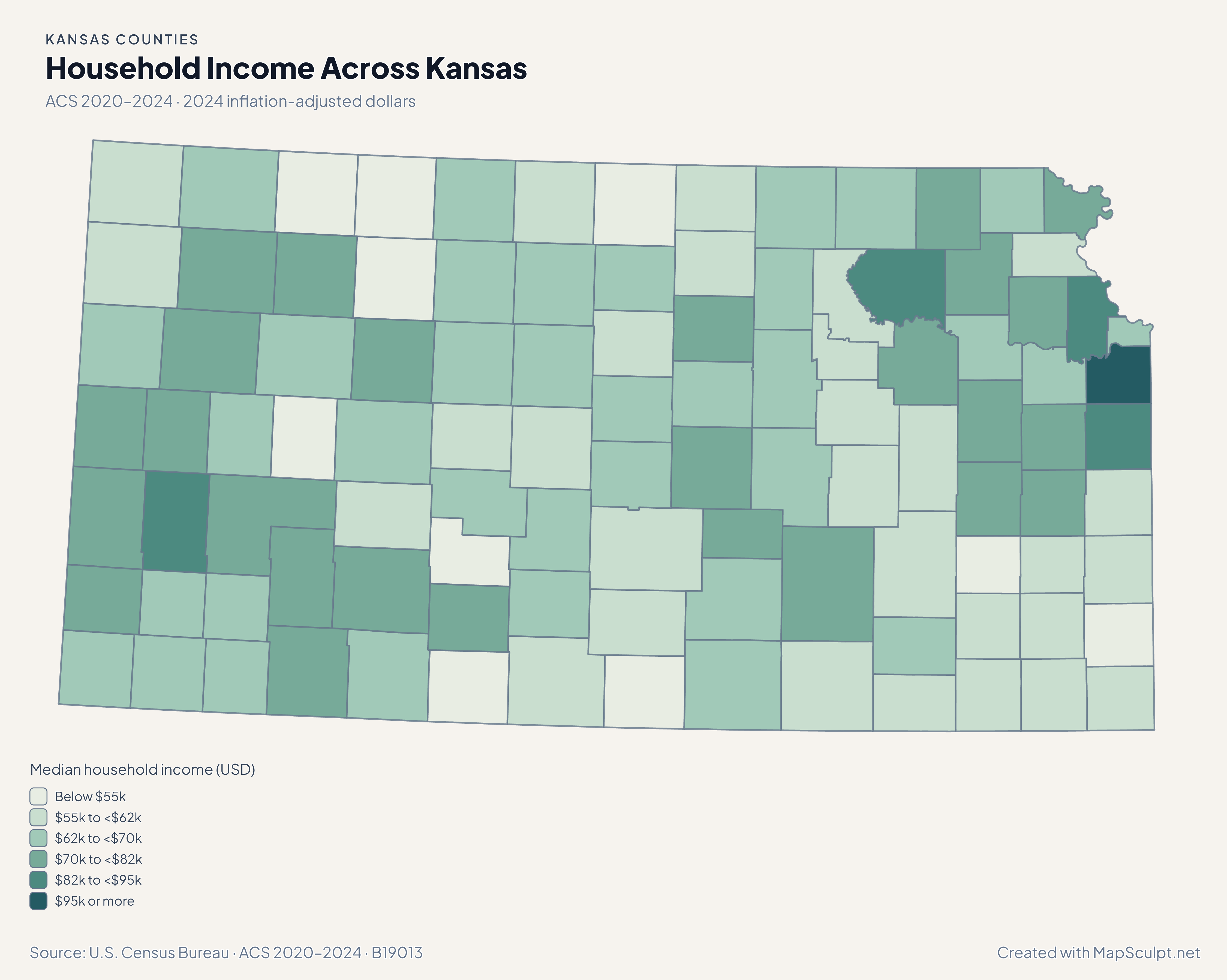
Household Income Across Kansas

ACS 2020–2024 · 2024 inflation-adjusted dollars

Kansas median household income map placing Johnson above Wyandotte and Sedgwick in the color scale.

Median household income (USD)

  • Below $55k
  • $55k to <$62k
  • $62k to <$70k
  • $70k to <$82k
  • $82k to <$95k
  • $95k or more
U.S. Census Bureau · ACS 2020–2024 · B19013Download complete PNG ACS 2020–2024 estimates in 2024 dollars, subject to sampling uncertainty.

KNOW YOUR GEOGRAPHY

Kansas counties across the plains and river borders

The editor retains all 105 Census county shapes. Its generally rectilinear interior boundaries and the irregular northeastern state edge follow the same generalized Census source.

The Kansas side of the Kansas City area includes Johnson and Wyandotte counties. Use county estimates for these shapes. The editor does not divide the metro area into city boundaries or extend into Missouri.

Browse all county GEOIDs ↗

2025 Census boundaries

OFFICIAL DATA

Household income across Kansas and within its metro areas

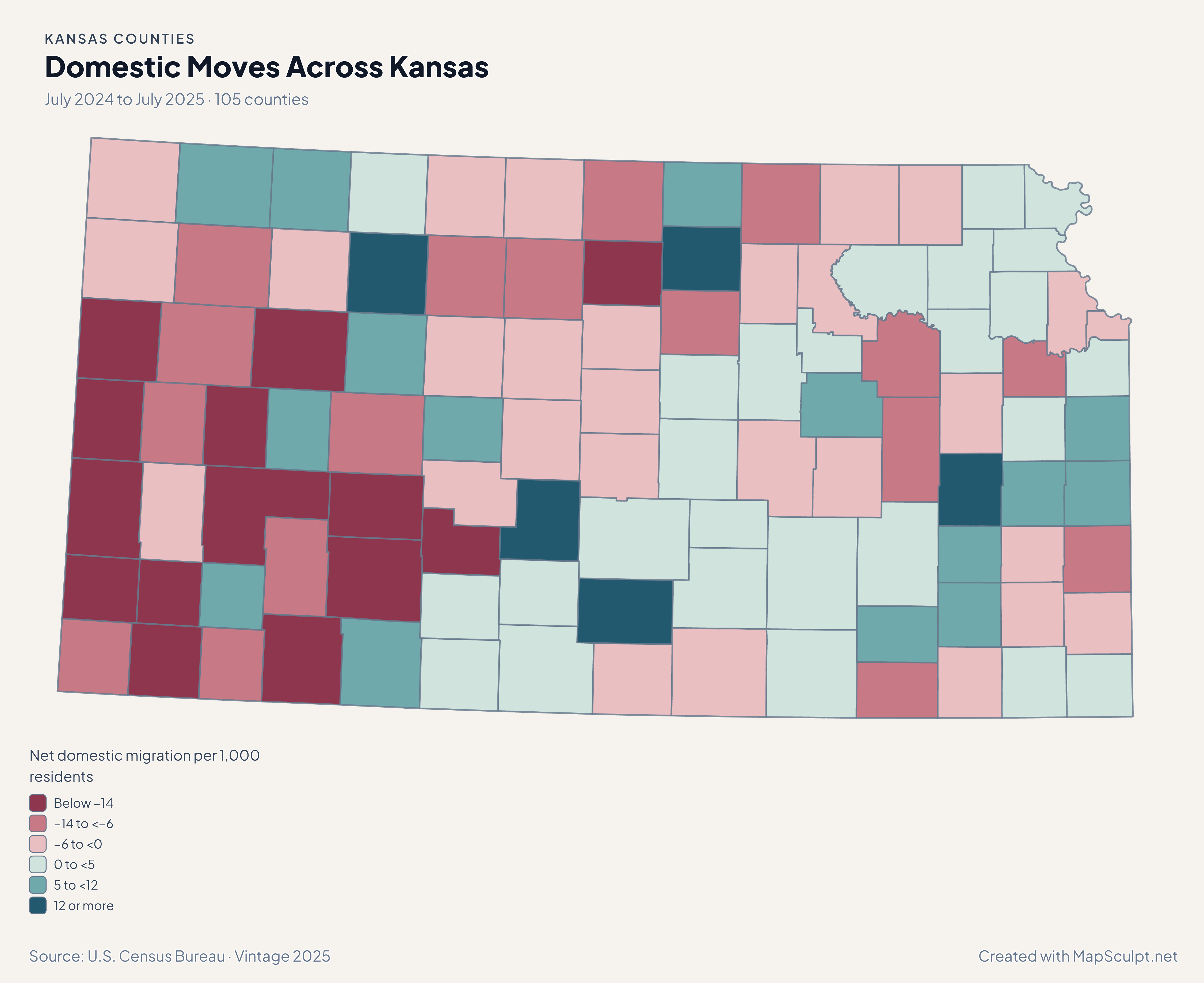
Read income as an ACS household estimate, then compare population and domestic moves in a separate July-to-July period.

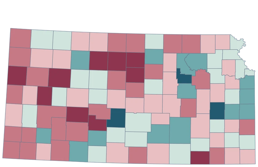
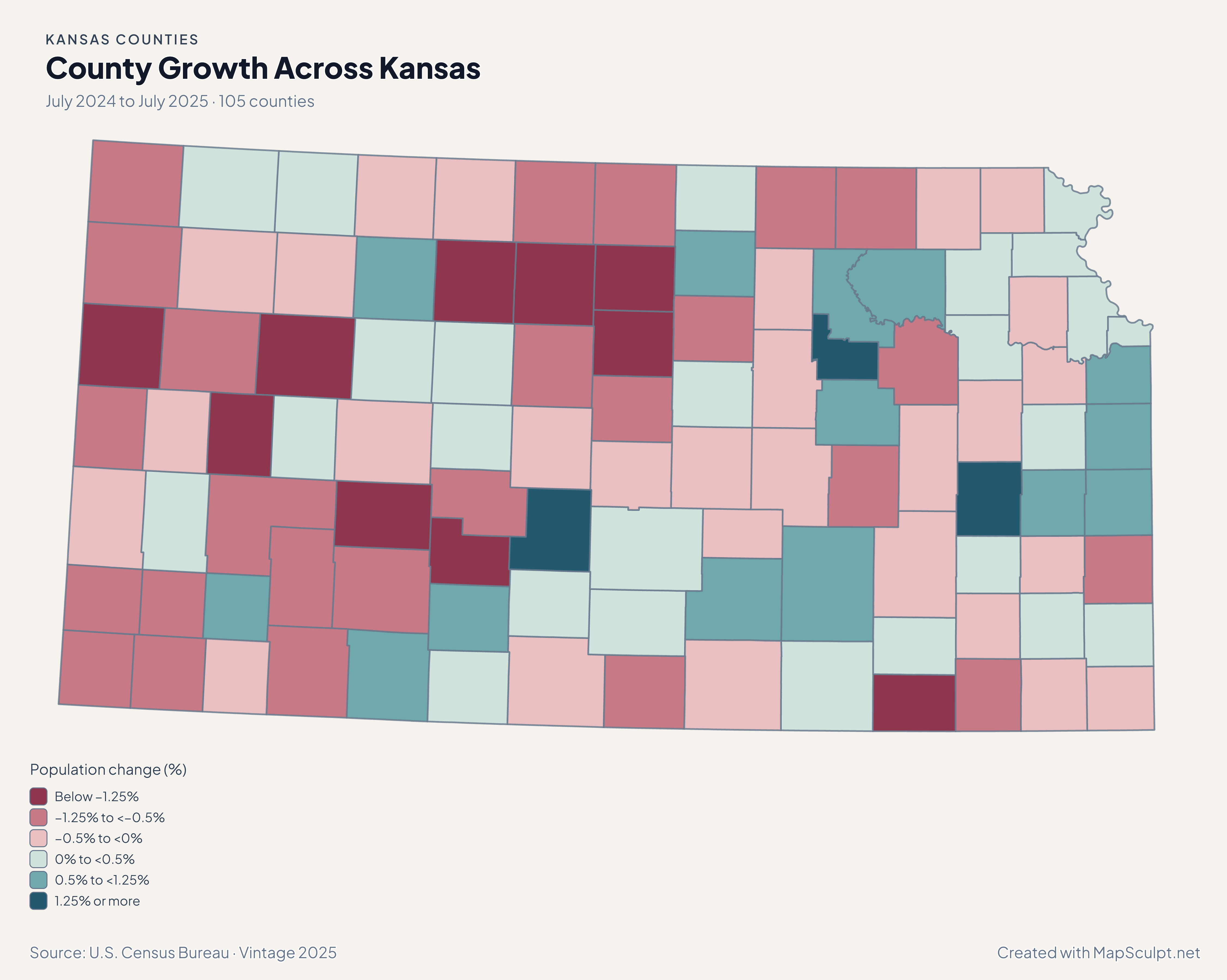
Kansas county population-change map showing gains near Kansas City and Wichita alongside losses in other areas.

July 2024 to July 2025 · 105 counties

Johnson, Sedgwick and Wyandotte all gained population

Johnson grew 0.96%, Sedgwick 0.76%, and Wyandotte 0.43%. Across Kansas, 40 counties grew, 63 declined, and two had the same estimated population in both Julys.

Population change (%)

  • Below −1.25%
  • −1.25% to <−0.5%
  • −0.5% to <0%
  • 0% to <0.5%
  • 0.5% to <1.25%
  • 1.25% or more

U.S. Census Bureau · Vintage 2025

Download complete PNG

Johnson County’s estimated median household income was $109,208, compared with $63,631 in Wyandotte and $69,365 in Sedgwick. All values are in 2024 dollars and are subject to ACS sampling uncertainty. See the Census estimates ↗

MAKE IT YOURS

From county data to a finished map.

  1. Open the Kansas editor

    Start with the full county-level geography.

  2. Match your rows by GEOID

    Use the five-character GEOIDs to distinguish Johnson and Wyandotte when comparing the Kansas City area.

  3. Choose colors a reader can interpret

    Label each class and include a date and units for numerical data.

  4. Export the annotated map

    Preview the title, legend and source, then download the PNG.

TRY CSV IMPORT

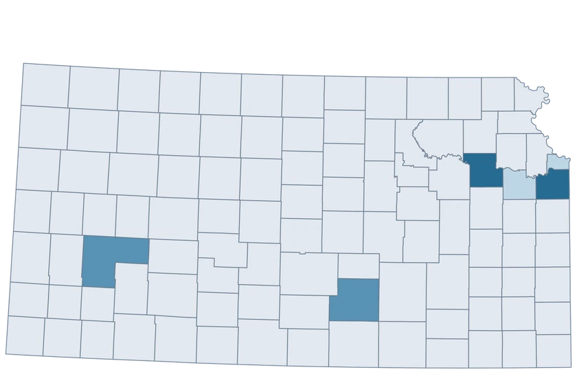
Try joining six official GEOIDs.

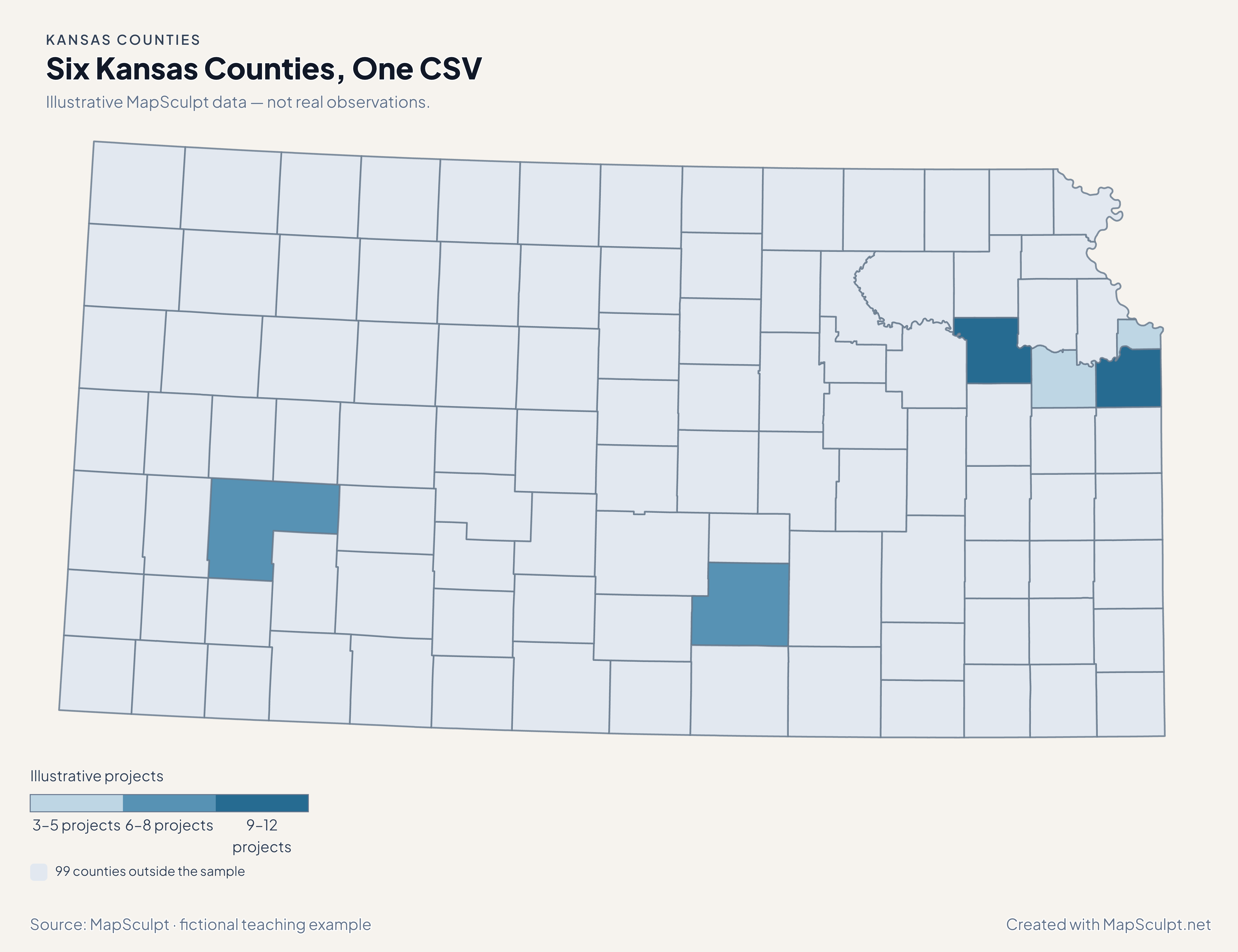
The fictional project values exercise three numeric bands. The remaining 99 counties keep the neutral fill.

Illustrative MapSculpt data — not real observations.
CountyGEOIDProjects
Johnson County2009112
Wyandotte County202095
Sedgwick County201738
Shawnee County201779
Douglas County200453
Finney County200556

Use the five-character GEOIDs to distinguish Johnson and Wyandotte when comparing the Kansas City area. Set custom boundaries of 3, 6, 9 and 12.

Download illustrative CSV ↓

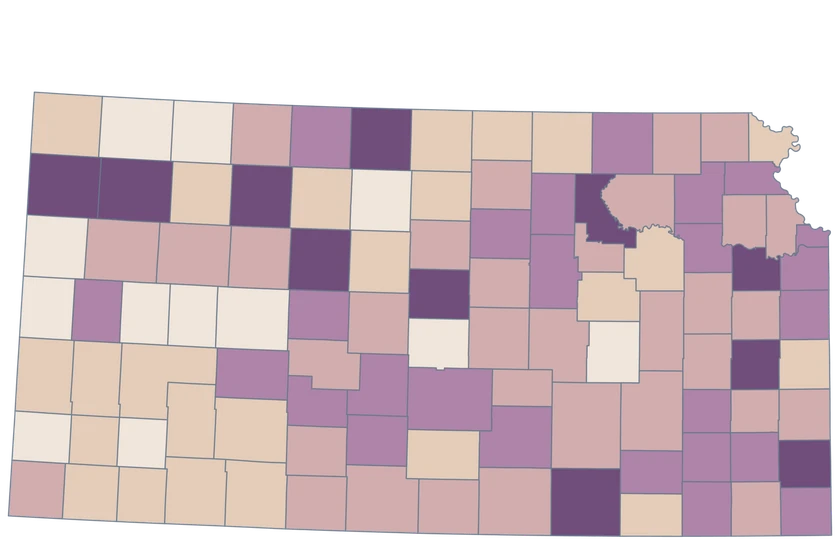
Six Kansas Counties, One CSV

Illustrative MapSculpt data — not real observations.

Illustrative Kansas map highlighting six GEOIDs and leaving 99 areas neutral.

Illustrative projects

  • 3–5 projects
  • 6–8 projects
  • 9–12 projects
  • 99 counties outside the sample
Download complete PNG

CSV → Match 6 counties → Style → Export PNG Create a Kansas map

COUNTY REFERENCE

Find all 105 Kansas counties and GEOIDs.

Official county names and five-digit Census GEOIDs. Search by name or code.

  1. Allen CountyGEOID 20001
  2. Anderson CountyGEOID 20003
  3. Atchison CountyGEOID 20005
  4. Barber CountyGEOID 20007
  5. Barton CountyGEOID 20009
  6. Bourbon CountyGEOID 20011
  7. Brown CountyGEOID 20013
  8. Butler CountyGEOID 20015
  9. Chase CountyGEOID 20017
  10. Chautauqua CountyGEOID 20019
  11. Cherokee CountyGEOID 20021
  12. Cheyenne CountyGEOID 20023
  13. Clark CountyGEOID 20025
  14. Clay CountyGEOID 20027
  15. Cloud CountyGEOID 20029
  16. Coffey CountyGEOID 20031
  17. Comanche CountyGEOID 20033
  18. Cowley CountyGEOID 20035
  19. Crawford CountyGEOID 20037
  20. Decatur CountyGEOID 20039
  21. Dickinson CountyGEOID 20041
  22. Doniphan CountyGEOID 20043
  23. Douglas CountyGEOID 20045
  24. Edwards CountyGEOID 20047
  25. Elk CountyGEOID 20049
  26. Ellis CountyGEOID 20051
  27. Ellsworth CountyGEOID 20053
  28. Finney CountyGEOID 20055
  29. Ford CountyGEOID 20057
  30. Franklin CountyGEOID 20059
  31. Geary CountyGEOID 20061
  32. Gove CountyGEOID 20063
  33. Graham CountyGEOID 20065
  34. Grant CountyGEOID 20067
  35. Gray CountyGEOID 20069
  36. Greeley CountyGEOID 20071
  37. Greenwood CountyGEOID 20073
  38. Hamilton CountyGEOID 20075
  39. Harper CountyGEOID 20077
  40. Harvey CountyGEOID 20079
  41. Haskell CountyGEOID 20081
  42. Hodgeman CountyGEOID 20083
  43. Jackson CountyGEOID 20085
  44. Jefferson CountyGEOID 20087
  45. Jewell CountyGEOID 20089
  46. Johnson CountyGEOID 20091
  47. Kearny CountyGEOID 20093
  48. Kingman CountyGEOID 20095
  49. Kiowa CountyGEOID 20097
  50. Labette CountyGEOID 20099
  51. Lane CountyGEOID 20101
  52. Leavenworth CountyGEOID 20103
  53. Lincoln CountyGEOID 20105
  54. Linn CountyGEOID 20107
  55. Logan CountyGEOID 20109
  56. Lyon CountyGEOID 20111
  57. Marion CountyGEOID 20115
  58. Marshall CountyGEOID 20117
  59. McPherson CountyGEOID 20113
  60. Meade CountyGEOID 20119
  61. Miami CountyGEOID 20121
  62. Mitchell CountyGEOID 20123
  63. Montgomery CountyGEOID 20125
  64. Morris CountyGEOID 20127
  65. Morton CountyGEOID 20129
  66. Nemaha CountyGEOID 20131
  67. Neosho CountyGEOID 20133
  68. Ness CountyGEOID 20135
  69. Norton CountyGEOID 20137
  70. Osage CountyGEOID 20139
  71. Osborne CountyGEOID 20141
  72. Ottawa CountyGEOID 20143
  73. Pawnee CountyGEOID 20145
  74. Phillips CountyGEOID 20147
  75. Pottawatomie CountyGEOID 20149
  76. Pratt CountyGEOID 20151
  77. Rawlins CountyGEOID 20153
  78. Reno CountyGEOID 20155
  79. Republic CountyGEOID 20157
  80. Rice CountyGEOID 20159
  81. Riley CountyGEOID 20161
  82. Rooks CountyGEOID 20163
  83. Rush CountyGEOID 20165
  84. Russell CountyGEOID 20167
  85. Saline CountyGEOID 20169
  86. Scott CountyGEOID 20171
  87. Sedgwick CountyGEOID 20173
  88. Seward CountyGEOID 20175
  89. Shawnee CountyGEOID 20177
  90. Sheridan CountyGEOID 20179
  91. Sherman CountyGEOID 20181
  92. Smith CountyGEOID 20183
  93. Stafford CountyGEOID 20185
  94. Stanton CountyGEOID 20187
  95. Stevens CountyGEOID 20189
  96. Sumner CountyGEOID 20191
  97. Thomas CountyGEOID 20193
  98. Trego CountyGEOID 20195
  99. Wabaunsee CountyGEOID 20197
  100. Wallace CountyGEOID 20199
  101. Washington CountyGEOID 20201
  102. Wichita CountyGEOID 20203
  103. Wilson CountyGEOID 20205
  104. Woodson CountyGEOID 20207
  105. Wyandotte CountyGEOID 20209
U.S. Census Bureau · 2025 Cartographic Boundary Files

COMMON QUESTIONS

Kansas county map questions.

How do I map the Kansas side of Kansas City?

Use 20091 for Johnson County and 20209 for Wyandotte County. For Missouri counties in the same metro area, use the U.S. Counties editor.

Which Kansas county should I use for the Wichita area?

Sedgwick County is 20173. Wichita is a municipality within that county, and its city statistics describe a different area.

Does the income layer tell me what individual workers earn?

It uses median household income from ACS B19013 in 2024 dollars. Household income combines sources for people in a household and differs from individual earnings.

Why does a county with no population change use the first nonnegative band?

The population legend starts its neutral-to-positive side at zero. A value exactly on a threshold enters the class beginning at that threshold.

Can I show western Kansas counties at a readable size?

Use a landscape export and keep a short legend. The smallest county shapes retain their Census identities, so you can also add labels to key counties.

What GEOID should I use for Lawrence-area county estimates?

Use 20045 for Douglas County. County and city estimates may differ, so check the geography field before you import.

YOUR NEXT MAP STARTS HERE

Build your own Kansas county map.

Compare counties on the same scale, highlight a region, or export a GEOID-linked map for a report.

Create a Kansas map