Skip to content
MapSculpt

GEOGRAPHIC MAP MAKER / VIRGINIA

Virginia
Counties Map Maker

Follow domestic moves across Northern Virginia, the Richmond area and Hampton Roads. Virginia’s county map includes independent cities, each with its own boundary and five-digit Census GEOID.

Free online editor · No sign-up required

133county equivalents
individually editable

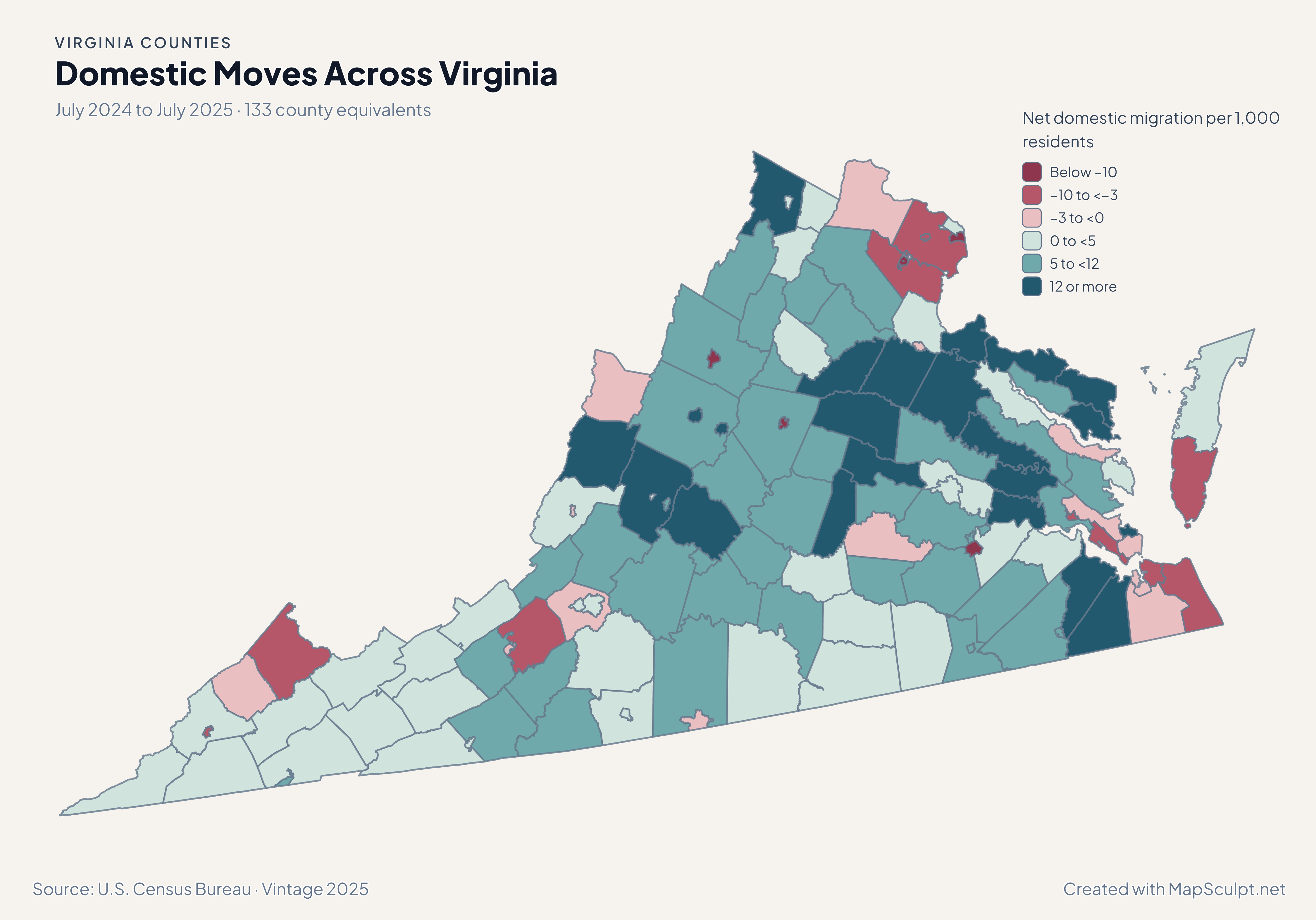
Domestic Moves Across Virginia

July 2024 to July 2025 · 133 county equivalents

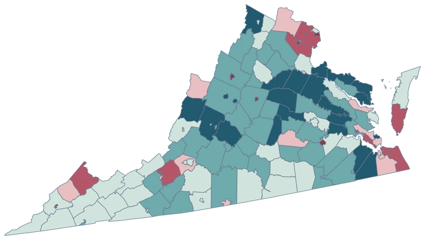
Virginia net domestic migration map with high gains near Richmond and loss shades in parts of Northern Virginia.

Net domestic migration per 1,000 residents

  • Below −10
  • −10 to <−3
  • −3 to <0
  • 0 to <5
  • 5 to <12
  • 12 or more
U.S. Census Bureau · Vintage 2025Download complete PNG Net domestic migration measures moves within the United States per 1,000 residents.

KNOW YOUR GEOGRAPHY

Counties and independent cities share the map.

The Census treats Virginia’s 95 counties and 38 independent cities as 133 county-level units. Fairfax County and Fairfax city are separate features, as are Richmond County and Richmond city.

Some independent cities are small or surrounded by county territory. Use a zoomed view for visual selection or a five-digit GEOID in your CSV to match the city precisely. Each multipart feature retains one Census identity.

Browse all county GEOIDs ↗

2025 Census boundaries

OFFICIAL DATA

Comparing counties and independent cities.

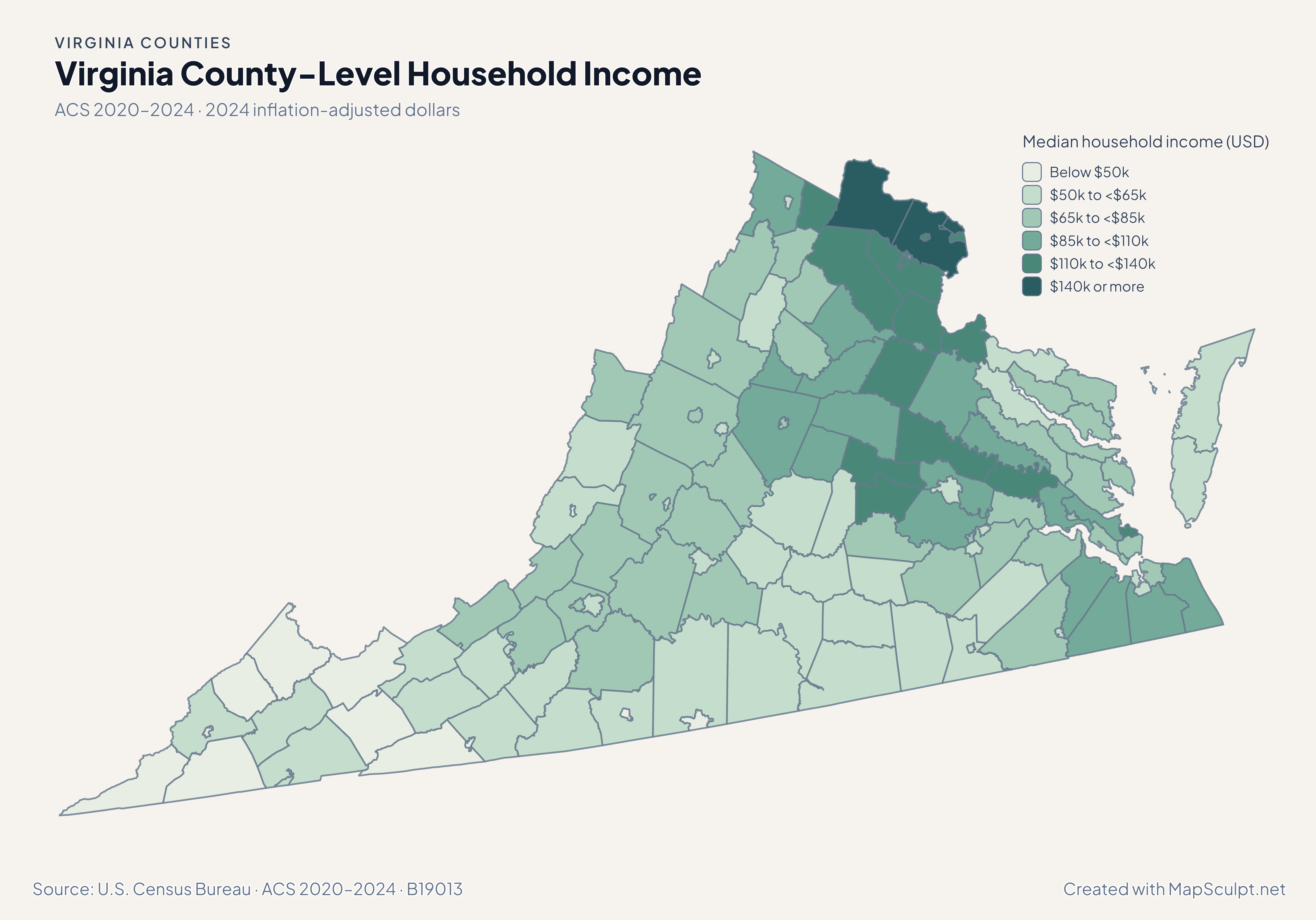
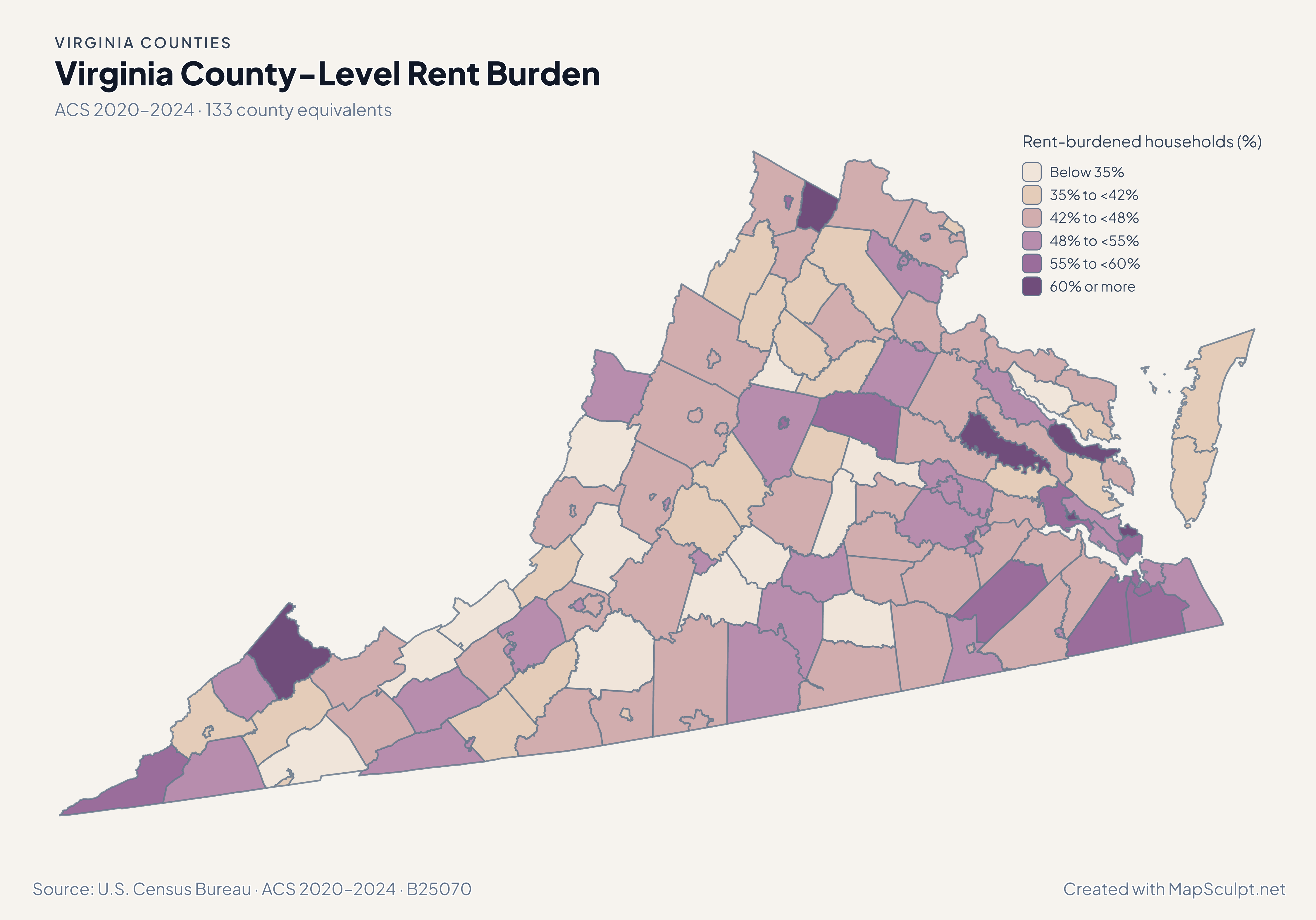
Compare July 2024–July 2025 population estimates with five-year ACS survey estimates for 2020–2024. Each map identifies its own period and units.

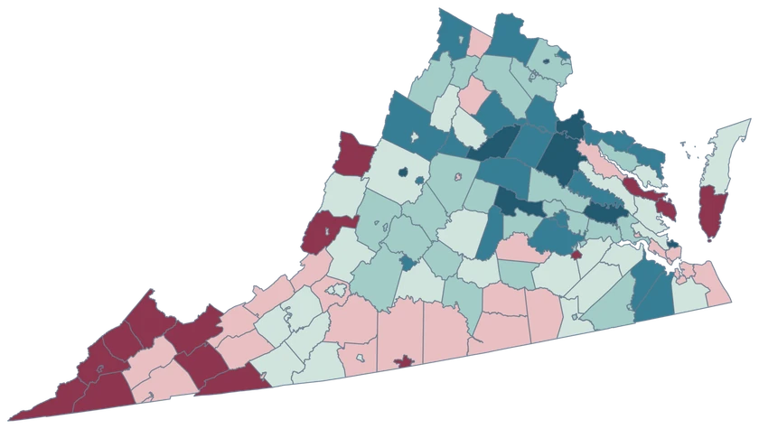
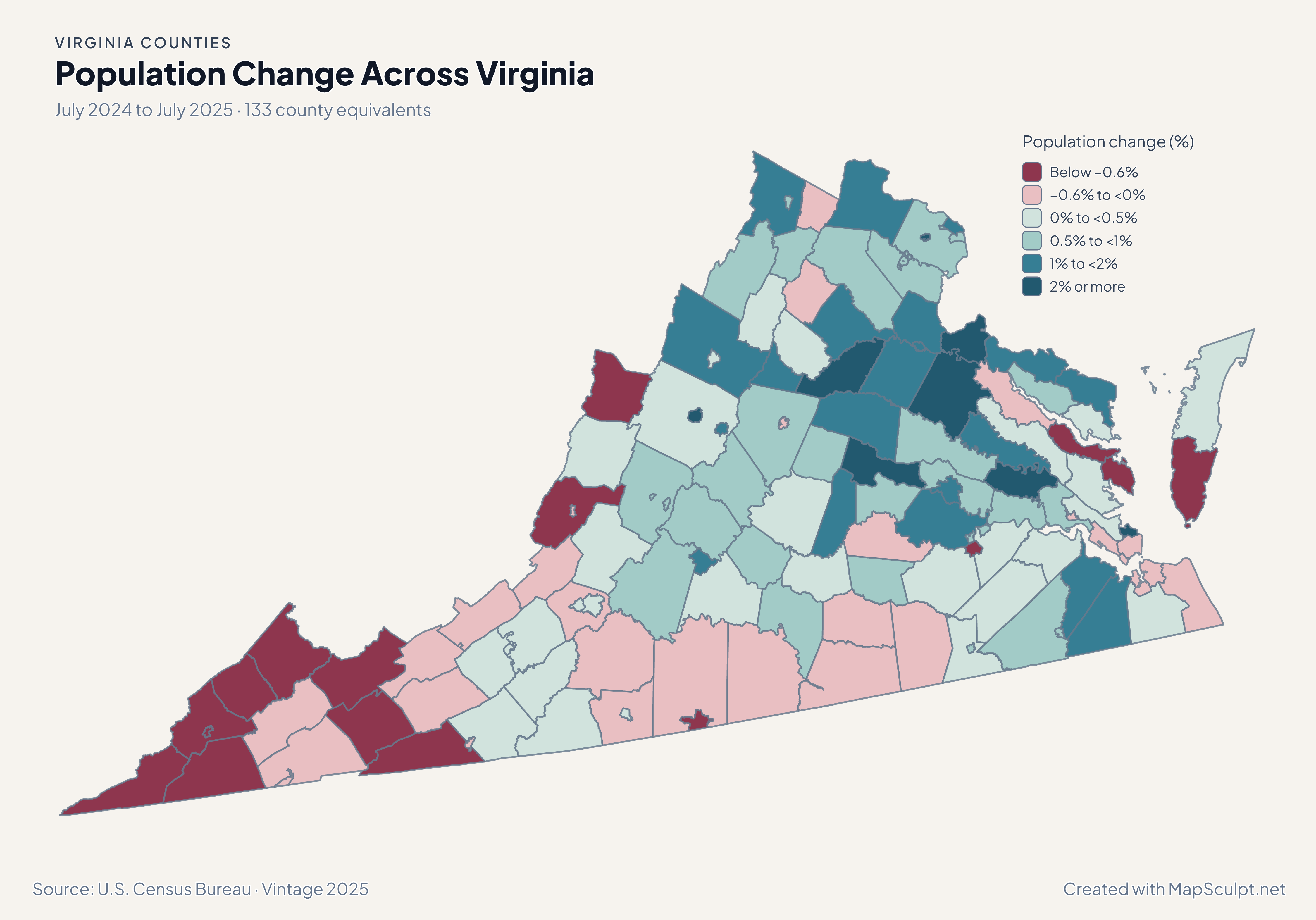
Virginia population change map showing counties and independently selectable cities, including growth in Poquoson.

July 2024 to July 2025 · 133 county equivalents

Independent cities and surrounding counties can move differently.

Poquoson city had the largest percentage gain at 3.34%, while nearby Williamsburg city declined 0.52%. Richmond city grew 1.04% and Richmond County grew 0.80%. The last two are separate places.

Population change (%)

  • Below −0.6%
  • −0.6% to <0%
  • 0% to <0.5%
  • 0.5% to <1%
  • 1% to <2%
  • 2% or more

U.S. Census Bureau · Vintage 2025

Download complete PNG

Goochland led at 36.38 net domestic movers per 1,000, while Alexandria city recorded −13.67. Fairfax County recorded −8.43 even as its population grew 0.70%. See the Census estimates ↗

MAKE IT YOURS

From county data to a finished map.

  1. Open the Virginia editor

    Start with all 133 selectable county equivalents.

  2. Match your county records

    Use a five-digit GEOID such as 51059 for Fairfax County. Review the match list before applying the data.

  3. Choose classes and colors

    Use bands that make the units and direction of change easy to read.

  4. Export with context

    Keep the source, period and legend visible in your full-resolution PNG.

TRY CSV IMPORT

Try six Virginia records.

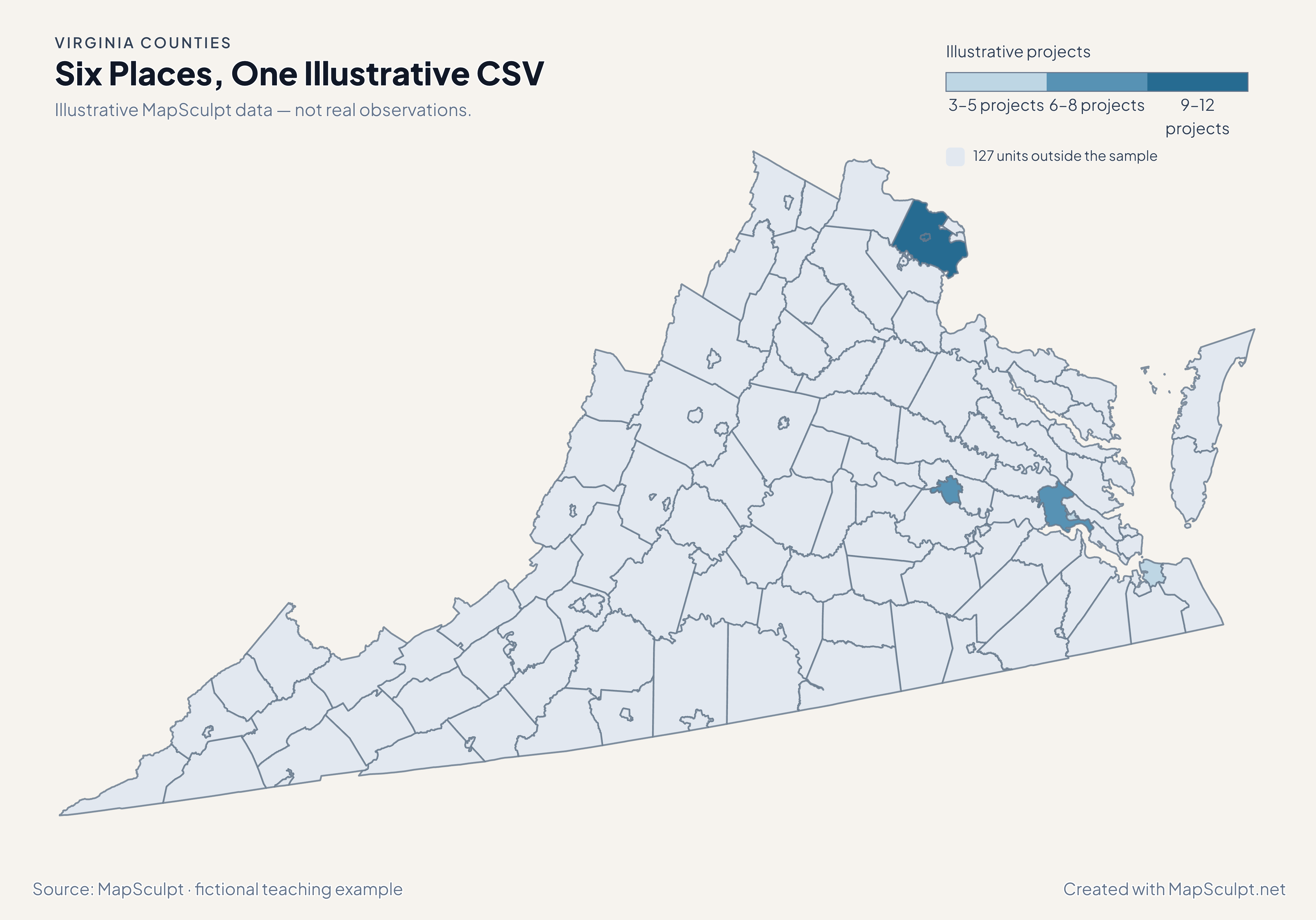
Import the fictional file, select IllustrativeProjects and use custom boundaries of 3, 6, 9 and 12. The remaining 127 units stay neutral.

Illustrative MapSculpt data — not real observations.
CountyGEOIDProjects
Fairfax County5105912
Fairfax city516009
Richmond city517607
Norfolk city517103
James City County510958
Williamsburg city518305

Keep IDs as text. The sample uses 51059 for Fairfax County and 51600 for Fairfax city.

Download illustrative CSV ↓

Six Places, One Illustrative CSV

Illustrative MapSculpt data — not real observations.

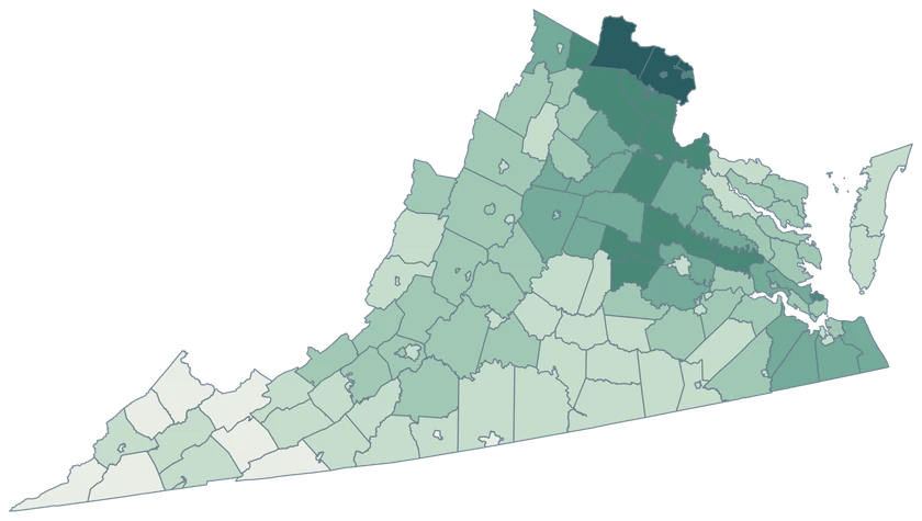
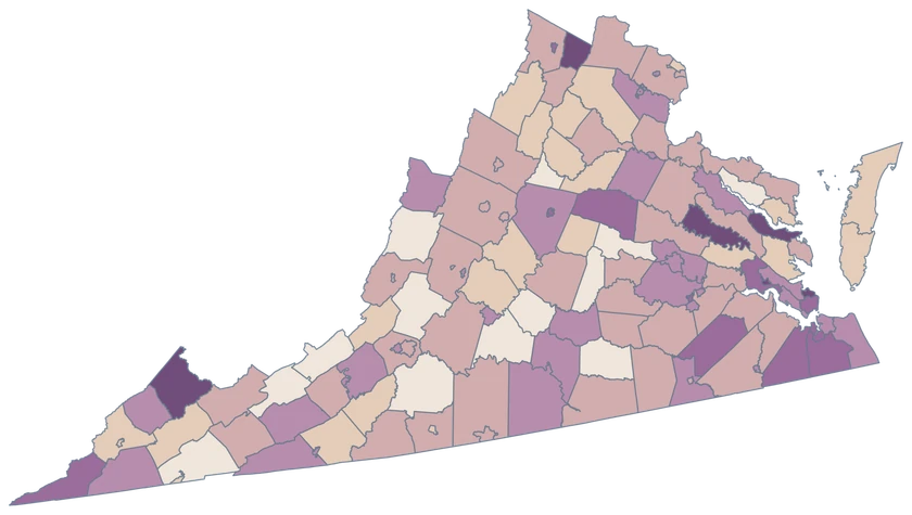
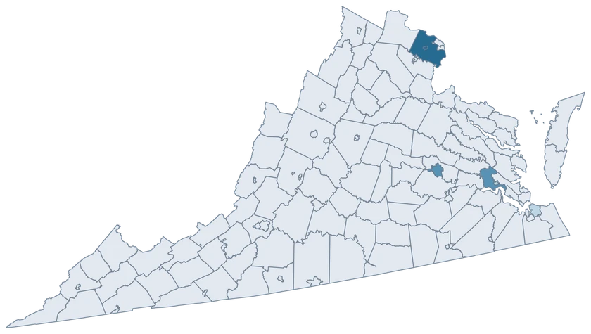
Virginia fictional project map with six sampled county-level units and 127 neutral units.

Illustrative projects

  • 3–5 projects
  • 6–8 projects
  • 9–12 projects
  • 127 units outside the sample
Download complete PNG

CSV → Match 6 county equivalents → Style → Export PNG Create a Virginia map

COUNTY REFERENCE

All 133 Virginia county equivalents and GEOIDs.

Official county and independent city names and five-digit Census GEOIDs. Search by name or code.

  1. Accomack CountyGEOID 51001
  2. Albemarle CountyGEOID 51003
  3. Alexandria cityGEOID 51510
  4. Alleghany CountyGEOID 51005
  5. Amelia CountyGEOID 51007
  6. Amherst CountyGEOID 51009
  7. Appomattox CountyGEOID 51011
  8. Arlington CountyGEOID 51013
  9. Augusta CountyGEOID 51015
  10. Bath CountyGEOID 51017
  11. Bedford CountyGEOID 51019
  12. Bland CountyGEOID 51021
  13. Botetourt CountyGEOID 51023
  14. Bristol cityGEOID 51520
  15. Brunswick CountyGEOID 51025
  16. Buchanan CountyGEOID 51027
  17. Buckingham CountyGEOID 51029
  18. Buena Vista cityGEOID 51530
  19. Campbell CountyGEOID 51031
  20. Caroline CountyGEOID 51033
  21. Carroll CountyGEOID 51035
  22. Charles City CountyGEOID 51036
  23. Charlotte CountyGEOID 51037
  24. Charlottesville cityGEOID 51540
  25. Chesapeake cityGEOID 51550
  26. Chesterfield CountyGEOID 51041
  27. Clarke CountyGEOID 51043
  28. Colonial Heights cityGEOID 51570
  29. Covington cityGEOID 51580
  30. Craig CountyGEOID 51045
  31. Culpeper CountyGEOID 51047
  32. Cumberland CountyGEOID 51049
  33. Danville cityGEOID 51590
  34. Dickenson CountyGEOID 51051
  35. Dinwiddie CountyGEOID 51053
  36. Emporia cityGEOID 51595
  37. Essex CountyGEOID 51057
  38. Fairfax cityGEOID 51600
  39. Fairfax CountyGEOID 51059
  40. Falls Church cityGEOID 51610
  41. Fauquier CountyGEOID 51061
  42. Floyd CountyGEOID 51063
  43. Fluvanna CountyGEOID 51065
  44. Franklin cityGEOID 51620
  45. Franklin CountyGEOID 51067
  46. Frederick CountyGEOID 51069
  47. Fredericksburg cityGEOID 51630
  48. Galax cityGEOID 51640
  49. Giles CountyGEOID 51071
  50. Gloucester CountyGEOID 51073
  51. Goochland CountyGEOID 51075
  52. Grayson CountyGEOID 51077
  53. Greene CountyGEOID 51079
  54. Greensville CountyGEOID 51081
  55. Halifax CountyGEOID 51083
  56. Hampton cityGEOID 51650
  57. Hanover CountyGEOID 51085
  58. Harrisonburg cityGEOID 51660
  59. Henrico CountyGEOID 51087
  60. Henry CountyGEOID 51089
  61. Highland CountyGEOID 51091
  62. Hopewell cityGEOID 51670
  63. Isle of Wight CountyGEOID 51093
  64. James City CountyGEOID 51095
  65. King and Queen CountyGEOID 51097
  66. King George CountyGEOID 51099
  67. King William CountyGEOID 51101
  68. Lancaster CountyGEOID 51103
  69. Lee CountyGEOID 51105
  70. Lexington cityGEOID 51678
  71. Loudoun CountyGEOID 51107
  72. Louisa CountyGEOID 51109
  73. Lunenburg CountyGEOID 51111
  74. Lynchburg cityGEOID 51680
  75. Madison CountyGEOID 51113
  76. Manassas cityGEOID 51683
  77. Manassas Park cityGEOID 51685
  78. Martinsville cityGEOID 51690
  79. Mathews CountyGEOID 51115
  80. Mecklenburg CountyGEOID 51117
  81. Middlesex CountyGEOID 51119
  82. Montgomery CountyGEOID 51121
  83. Nelson CountyGEOID 51125
  84. New Kent CountyGEOID 51127
  85. Newport News cityGEOID 51700
  86. Norfolk cityGEOID 51710
  87. Northampton CountyGEOID 51131
  88. Northumberland CountyGEOID 51133
  89. Norton cityGEOID 51720
  90. Nottoway CountyGEOID 51135
  91. Orange CountyGEOID 51137
  92. Page CountyGEOID 51139
  93. Patrick CountyGEOID 51141
  94. Petersburg cityGEOID 51730
  95. Pittsylvania CountyGEOID 51143
  96. Poquoson cityGEOID 51735
  97. Portsmouth cityGEOID 51740
  98. Powhatan CountyGEOID 51145
  99. Prince Edward CountyGEOID 51147
  100. Prince George CountyGEOID 51149
  101. Prince William CountyGEOID 51153
  102. Pulaski CountyGEOID 51155
  103. Radford cityGEOID 51750
  104. Rappahannock CountyGEOID 51157
  105. Richmond cityGEOID 51760
  106. Richmond CountyGEOID 51159
  107. Roanoke cityGEOID 51770
  108. Roanoke CountyGEOID 51161
  109. Rockbridge CountyGEOID 51163
  110. Rockingham CountyGEOID 51165
  111. Russell CountyGEOID 51167
  112. Salem cityGEOID 51775
  113. Scott CountyGEOID 51169
  114. Shenandoah CountyGEOID 51171
  115. Smyth CountyGEOID 51173
  116. Southampton CountyGEOID 51175
  117. Spotsylvania CountyGEOID 51177
  118. Stafford CountyGEOID 51179
  119. Staunton cityGEOID 51790
  120. Suffolk cityGEOID 51800
  121. Surry CountyGEOID 51181
  122. Sussex CountyGEOID 51183
  123. Tazewell CountyGEOID 51185
  124. Virginia Beach cityGEOID 51810
  125. Warren CountyGEOID 51187
  126. Washington CountyGEOID 51191
  127. Waynesboro cityGEOID 51820
  128. Westmoreland CountyGEOID 51193
  129. Williamsburg cityGEOID 51830
  130. Winchester cityGEOID 51840
  131. Wise CountyGEOID 51195
  132. Wythe CountyGEOID 51197
  133. York CountyGEOID 51199

U.S. Census Bureau · 2025 Cartographic Boundary Files

COMMON QUESTIONS

Virginia county map questions.

Why are there 133 entries in Virginia’s directory?

The Census inventory includes 95 counties and 38 independent cities. Each independent city is a separate county equivalent with its own GEOID.

How do I distinguish Fairfax County and Fairfax city?

Use 51059 for Fairfax County and 51600 for Fairfax city. Keep the identities separate even when reports shorten both names to Fairfax.

Is Richmond city part of Richmond County?

They are separate jurisdictions. Use 51760 for Richmond city and 51159 for Richmond County.

How can I select a tiny independent city?

Zoom in to its outline or match the five-digit GEOID in a CSV. The editor keeps the city as its own selectable feature.

Can I map Norfolk and nearby counties together?

Yes. Norfolk city, GEOID 51710, and every county equivalent around Hampton Roads have their own records. Group them only if your project calls for a regional view.

Can the same Virginia CSV contain city and county rows?

Yes. Use distinct county-equivalent GEOIDs for the city and county observations. The illustrative file demonstrates this with Fairfax County and Fairfax city.

YOUR NEXT MAP STARTS HERE

Put your Virginia data on the map.

Choose a comparison for Virginia, join your observations by Census GEOID and export a map with the period and source included.

Create a Virginia map