Skip to content
MapSculpt

GEOGRAPHIC MAP MAKER / NEW YORK

New York
Counties Map Maker

Color all 62 New York State counties. Import your data, style your legend, and export a high-resolution custom map.

Free online editor · No sign-up required

62counties
individually editable

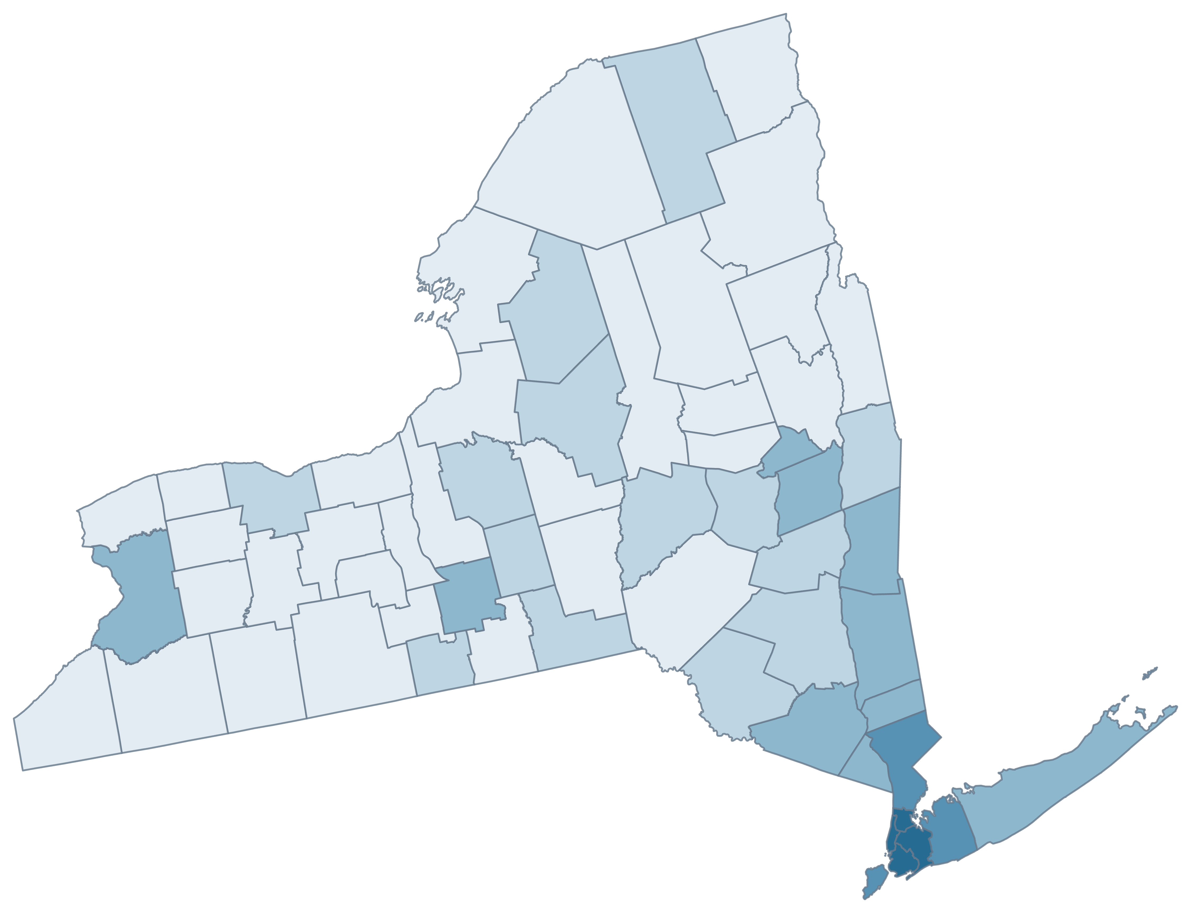
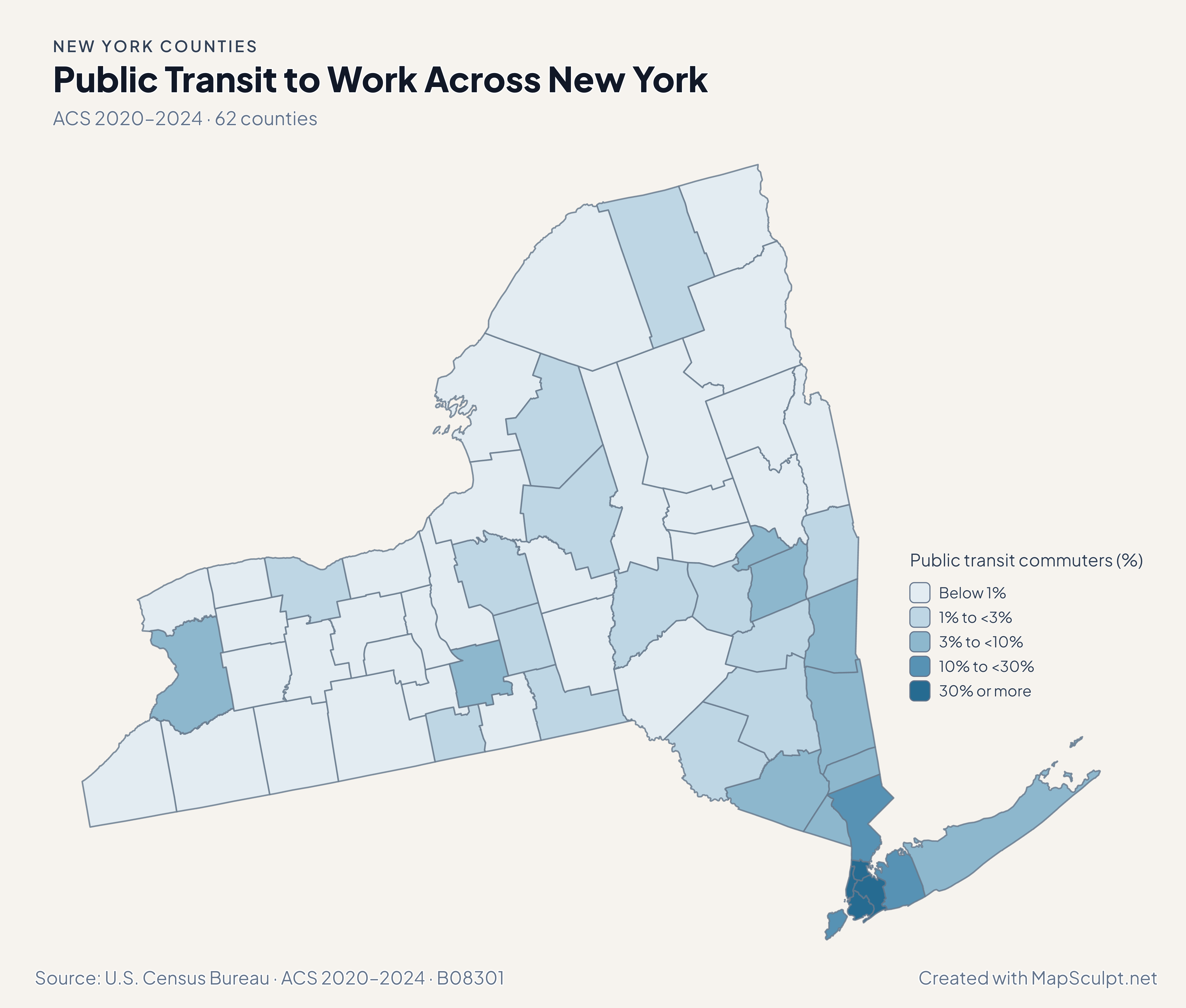
Public Transit to Work Across New York

ACS 2020–2024 · 62 counties

New York county map showing the share of commuters who use public transit. The highest estimated share is in New York County.

Public transit commuters (%)

  • Below 1%
  • 1% to <3%
  • 3% to <10%
  • 10% to <30%
  • 30% or more
U.S. Census Bureau · ACS 2020–2024 · B08301View full-size map Share of workers age 16 and older who commuted. Workers who worked from home are excluded.

01 / KNOW YOUR GEOGRAPHY

62 counties. One New York State.

Across western New York, the Hudson Valley, New York City and Long Island, all 62 counties are individually editable. The five NYC boroughs correspond to five of those counties.

City limits, ZIP codes and congressional districts use different boundaries.

Browse all 62 county FIPS codes

02 / OFFICIAL DATA

One state. Many stories.

Explore different sides of New York through official county-level data mapped with MapSculpt.

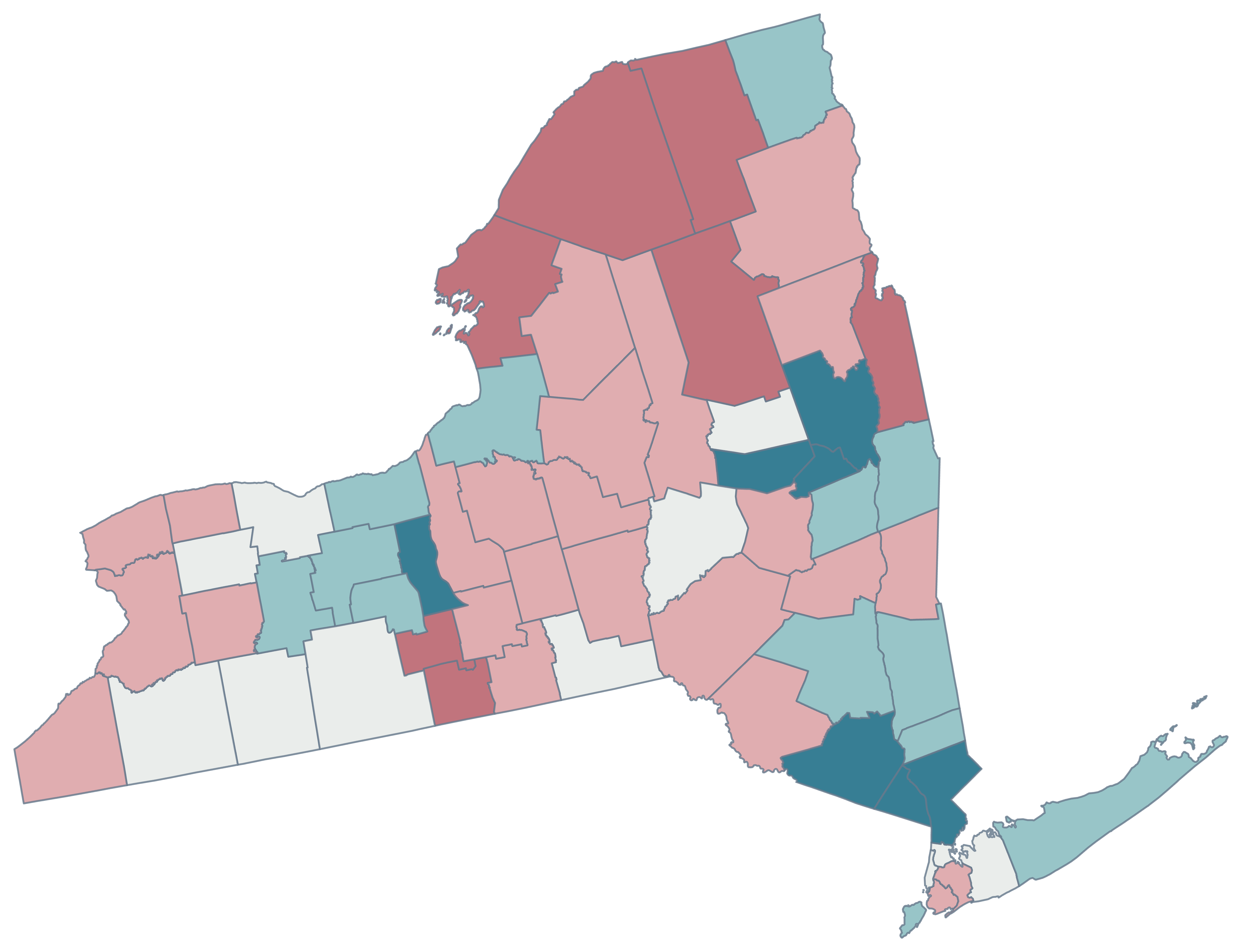
New York county map showing July 2024 to July 2025 population declines in rose and gains in teal.

01 / CENSUS · POPULATION CHANGE 2024–2025

Where New York gained and lost residents.

Compare estimated population changes across all 62 counties from July 1, 2024, to July 1, 2025.

counties gained residents
24
counties lost residents
38

Population change reflects births, deaths and net migration.

Population change (%)

  • Below −0.5%
  • −0.5% to <−0.1%
  • −0.1% to <0.1%
  • 0.1% to <0.5%
  • 0.5% or more

U.S. Census Bureau · Vintage 2025 Population Estimates

Create a New York county map

MAKE IT YOURS

From county data to a finished map.

  1. Choose New York counties

    Open the New York editor, choose a palette, and start with the full statewide map.

  2. Import your CSV

    Match five-digit GEOIDs, county names or supported NYC borough aliases, then review your matches.

  3. Add context

    Add a title, source and readable legend with the Text tool, then customize colors and borders.

  4. Export your PNG

    Choose a map style and background, then download an image for your project.

03 / NYC BOROUGH COUNTY CSV

From borough names to a county map.

The five NYC boroughs correspond to five official counties. Match their GEOIDs or borough aliases, review the values, and export a map.

Census 2025 · Five-county sample
County / boroughGEOIDChange (%)
Bronx36005+0.02%
Brooklyn36047−0.18%
Manhattan36061−0.04%
Queens36081−0.37%
Staten Island36085+0.34%

U.S. Census Bureau · Vintage 2025 Population Estimates

Keep county GEOIDs as text. Use Brooklyn or Kings County for Brooklyn, and Manhattan or New York County for Manhattan.

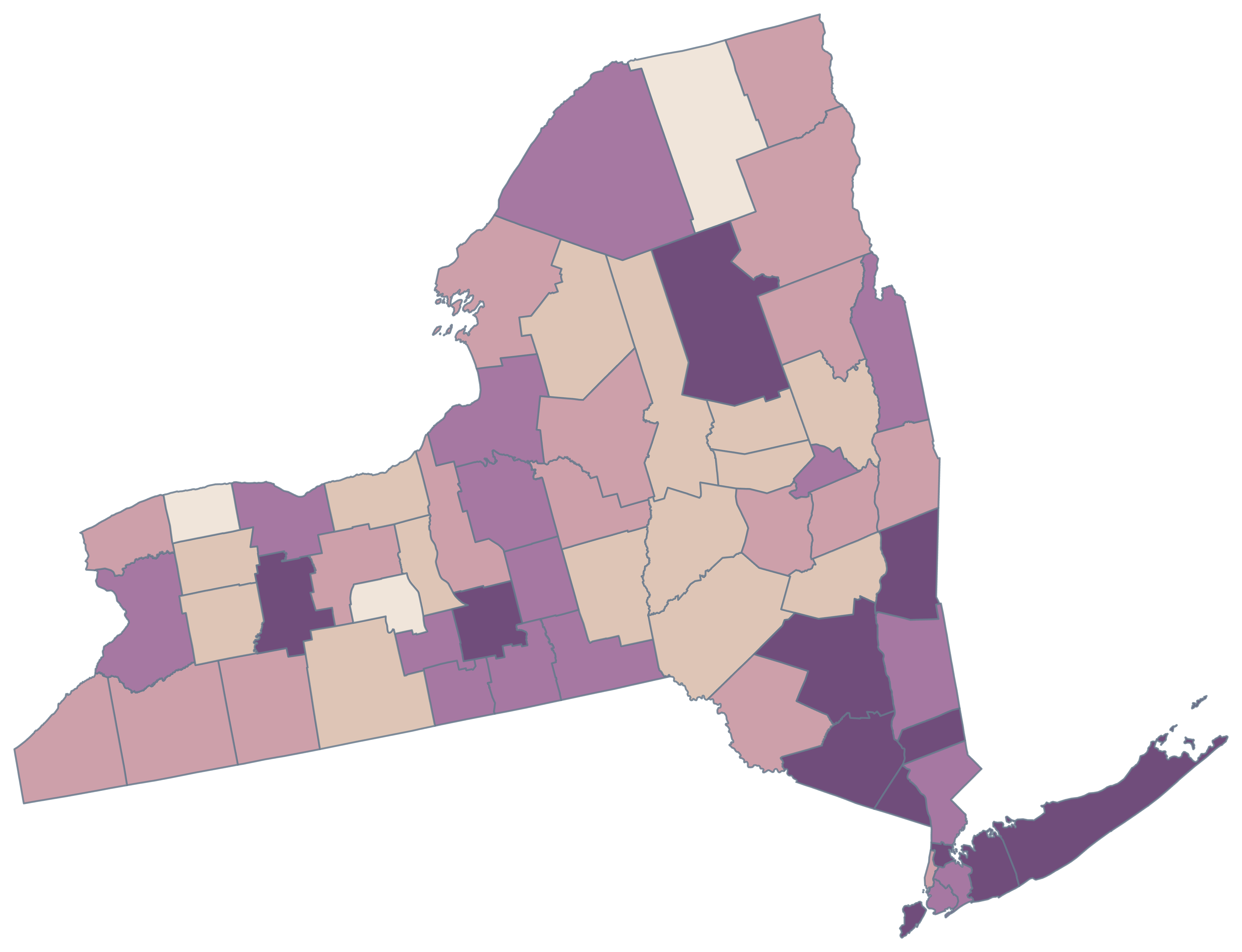
Five NYC borough-counties

Population change · July 2024 to July 2025

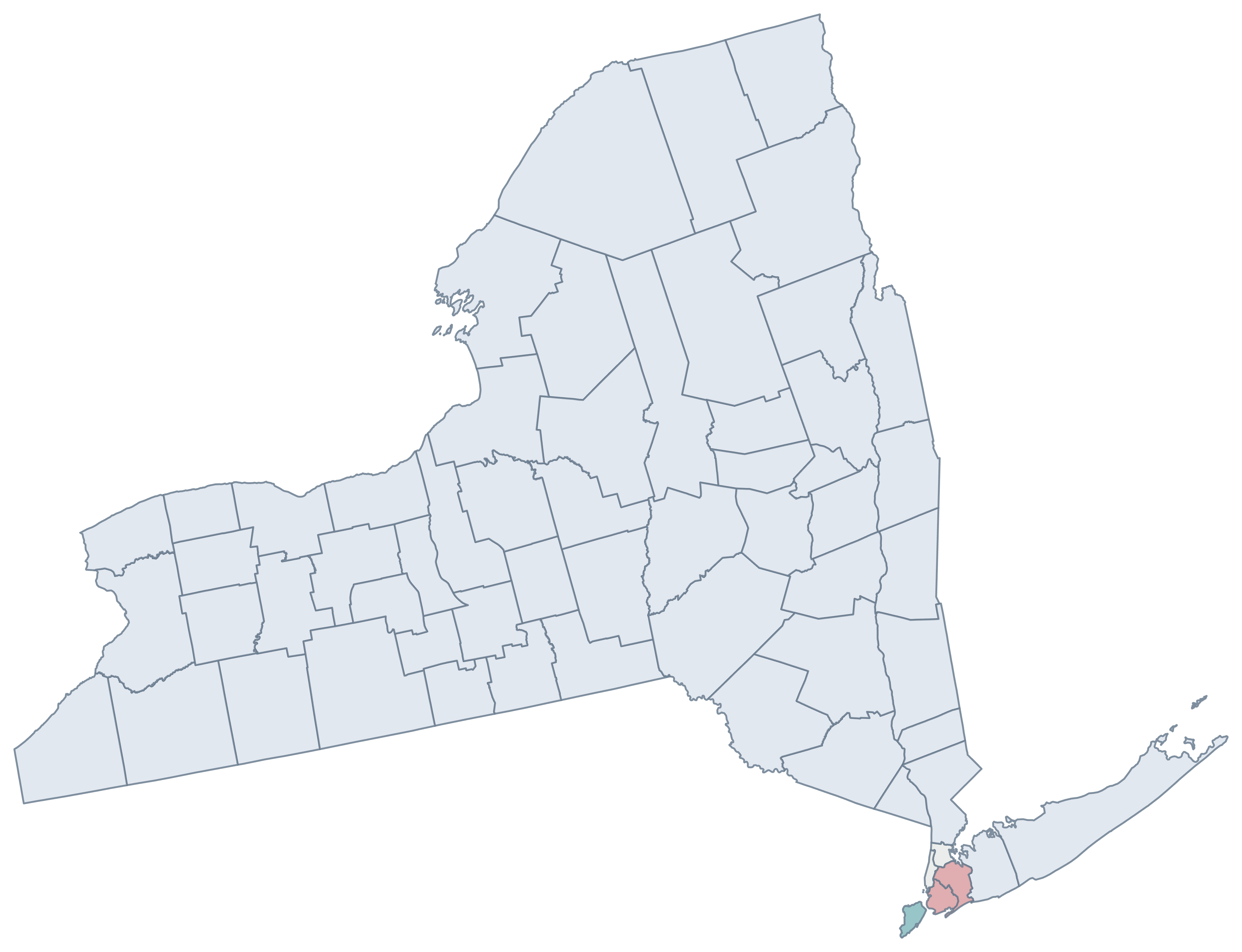
New York map colored by population change for the five New York City borough-counties. The remaining 57 counties are neutral.
  • Bronx · +0.02%
  • Brooklyn · −0.18%
  • Manhattan · −0.04%
  • Queens · −0.37%
  • Staten Island · +0.34%
  • 57 counties outside the sample

CSV → Match five counties → Color → Export PNG Create a New York map

NYC / COUNTY IDENTITY

Five boroughs. Five counties.

Each New York City borough corresponds to a county within New York State’s 62. MapSculpt recognizes all five borough names in the New York editor.

To map Manhattan, use New York County, Manhattan or 36061. “New York City” requires manual review.

BoroughOfficial countyGEOID
The BronxBronx County36005
BrooklynKings County36047
ManhattanNew York County36061
QueensQueens County36081
Staten IslandRichmond County36085

NYC311 · Official borough and county equivalents

04 / NEW YORK COUNTY REFERENCE

New York’s 62 counties.

All 62 official county names and five-digit Census GEOIDs. The five NYC boroughs are included in the county list.

  1. Albany CountyFIPS 36001
  2. Allegany CountyFIPS 36003
  3. Bronx CountyFIPS 36005
  4. Broome CountyFIPS 36007
  5. Cattaraugus CountyFIPS 36009
  6. Cayuga CountyFIPS 36011
  7. Chautauqua CountyFIPS 36013
  8. Chemung CountyFIPS 36015
  9. Chenango CountyFIPS 36017
  10. Clinton CountyFIPS 36019
  11. Columbia CountyFIPS 36021
  12. Cortland CountyFIPS 36023
  13. Delaware CountyFIPS 36025
  14. Dutchess CountyFIPS 36027
  15. Erie CountyFIPS 36029
  16. Essex CountyFIPS 36031
  17. Franklin CountyFIPS 36033
  18. Fulton CountyFIPS 36035
  19. Genesee CountyFIPS 36037
  20. Greene CountyFIPS 36039
  21. Hamilton CountyFIPS 36041
  22. Herkimer CountyFIPS 36043
  23. Jefferson CountyFIPS 36045
  24. Kings CountyFIPS 36047
  25. Lewis CountyFIPS 36049
  26. Livingston CountyFIPS 36051
  27. Madison CountyFIPS 36053
  28. Monroe CountyFIPS 36055
  29. Montgomery CountyFIPS 36057
  30. Nassau CountyFIPS 36059
  31. New York CountyFIPS 36061
  32. Niagara CountyFIPS 36063
  33. Oneida CountyFIPS 36065
  34. Onondaga CountyFIPS 36067
  35. Ontario CountyFIPS 36069
  36. Orange CountyFIPS 36071
  37. Orleans CountyFIPS 36073
  38. Oswego CountyFIPS 36075
  39. Otsego CountyFIPS 36077
  40. Putnam CountyFIPS 36079
  41. Queens CountyFIPS 36081
  42. Rensselaer CountyFIPS 36083
  43. Richmond CountyFIPS 36085
  44. Rockland CountyFIPS 36087
  45. Saratoga CountyFIPS 36091
  46. Schenectady CountyFIPS 36093
  47. Schoharie CountyFIPS 36095
  48. Schuyler CountyFIPS 36097
  49. Seneca CountyFIPS 36099
  50. St. Lawrence CountyFIPS 36089
  51. Steuben CountyFIPS 36101
  52. Suffolk CountyFIPS 36103
  53. Sullivan CountyFIPS 36105
  54. Tioga CountyFIPS 36107
  55. Tompkins CountyFIPS 36109
  56. Ulster CountyFIPS 36111
  57. Warren CountyFIPS 36113
  58. Washington CountyFIPS 36115
  59. Wayne CountyFIPS 36117
  60. Westchester CountyFIPS 36119
  61. Wyoming CountyFIPS 36121
  62. Yates CountyFIPS 36123

U.S. Census Bureau · 2025 Cartographic Boundary Files

COMMON QUESTIONS

New York county map questions.

How many counties does New York have?

New York State has 62 counties. Five correspond to New York City’s boroughs, and each county is separately selectable in MapSculpt.

Can I color individual New York counties?

Yes. Open the New York Counties editor, choose an individual county, apply a color, and customize borders, titles and legends before exporting.

Can I create a blank New York county map?

Yes. Keep the county fills neutral, customize the borders or title if you like, and export the map as a PNG.

Can I import county or borough data from a CSV?

Yes. Use official five-digit GEOIDs, county names or the supported borough aliases. Values such as “New York” and “New York City” require manual review.

How are the NYC boroughs represented?

The Bronx is Bronx County (36005), Brooklyn is Kings County (36047), Manhattan is New York County (36061), Queens is Queens County (36081), and Staten Island is Richmond County (36085).

Is Brooklyn the same as Kings County?

For county-level maps and Census records, Brooklyn corresponds to Kings County (36047). Use Kings County or the Brooklyn alias to match data in the New York editor.

Can I map Long Island and its counties?

Yes. Nassau and Suffolk are covered, as are Kings and Queens on western Long Island. Zoom in to select the smaller county shapes.

Can I export a high-resolution PNG?

Yes. MapSculpt exports your county colors and the titles, legends and source annotations you choose to include.

Does this map include New York City and upstate?

Yes. It covers the entire state, including western and northern New York, the Hudson Valley, New York City and Long Island.

Does the map include ZIP codes or city boundaries?

The map shows New York State counties. ZIP-code areas and municipal boundaries use different geographic units.

Is the New York county map maker free?

You can color counties and export a PNG for free without signing up. The editor shows the other options available for your map.

YOUR NEXT MAP STARTS HERE

Make New York’s geography your own.

Start with 62 counties, including five NYC borough-counties. Create something worth sharing.

Create a New York map