MapSculpt

BRAZIL / 26 STATES + FEDERAL DISTRICTBRAZIL / 26 STATES + DF

Brazil States Map MakerBrazil States Map Maker

Color Brazil's 26 states and the Federal District. Customize the colors, add a title and legend, and download your map as a PNG.Color Brazil's states, add a legend, and download your map.

Create a Brazil Map

Free online map maker · No design experience required

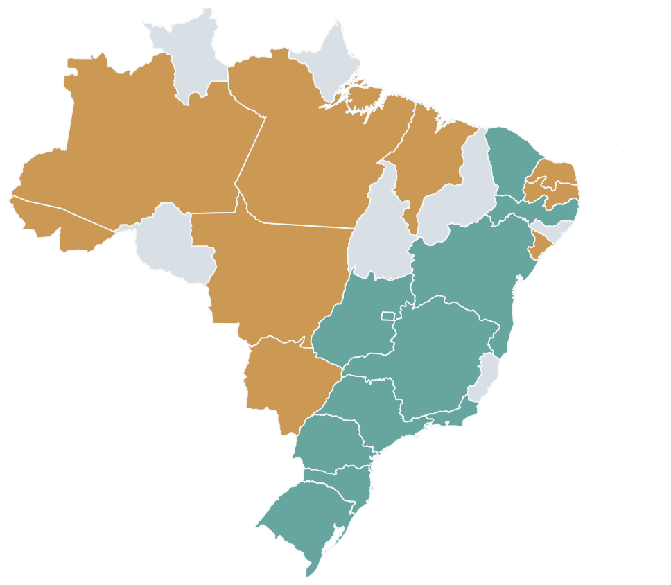
MAP EXAMPLE / 5 REGIONSCUSTOM BRAZIL MAP

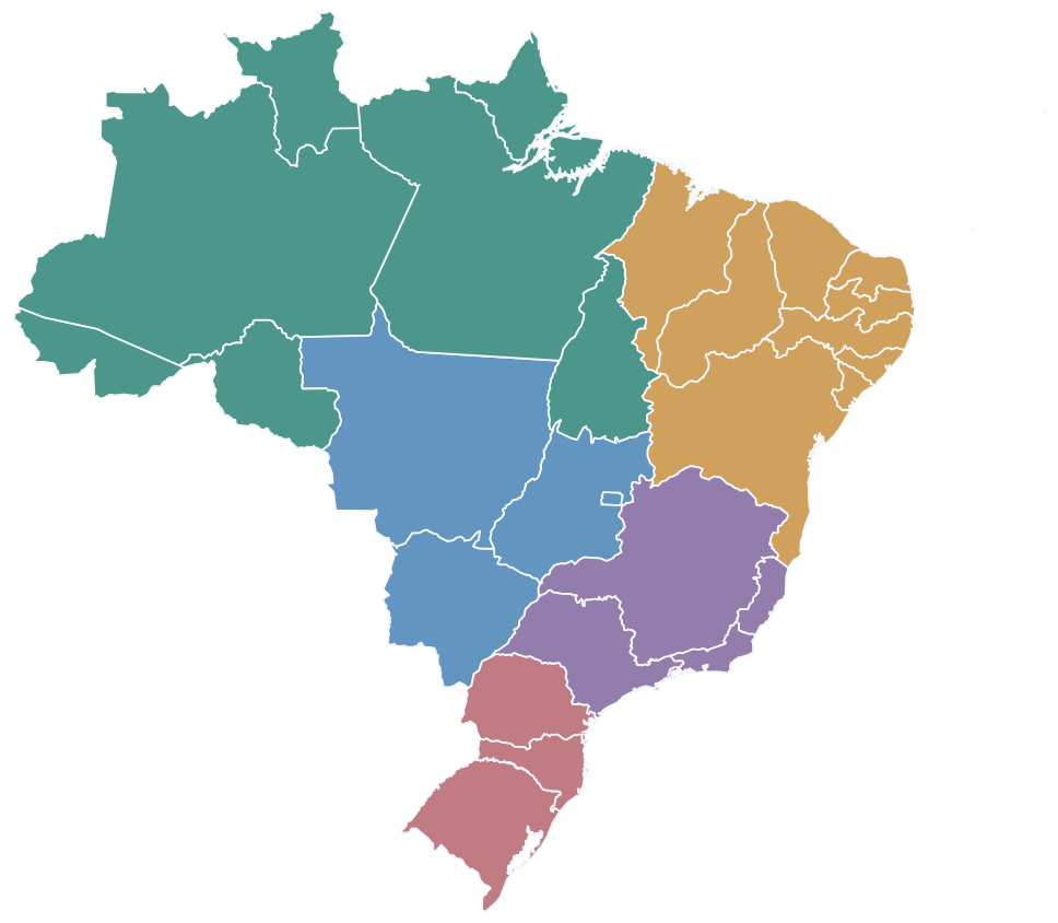
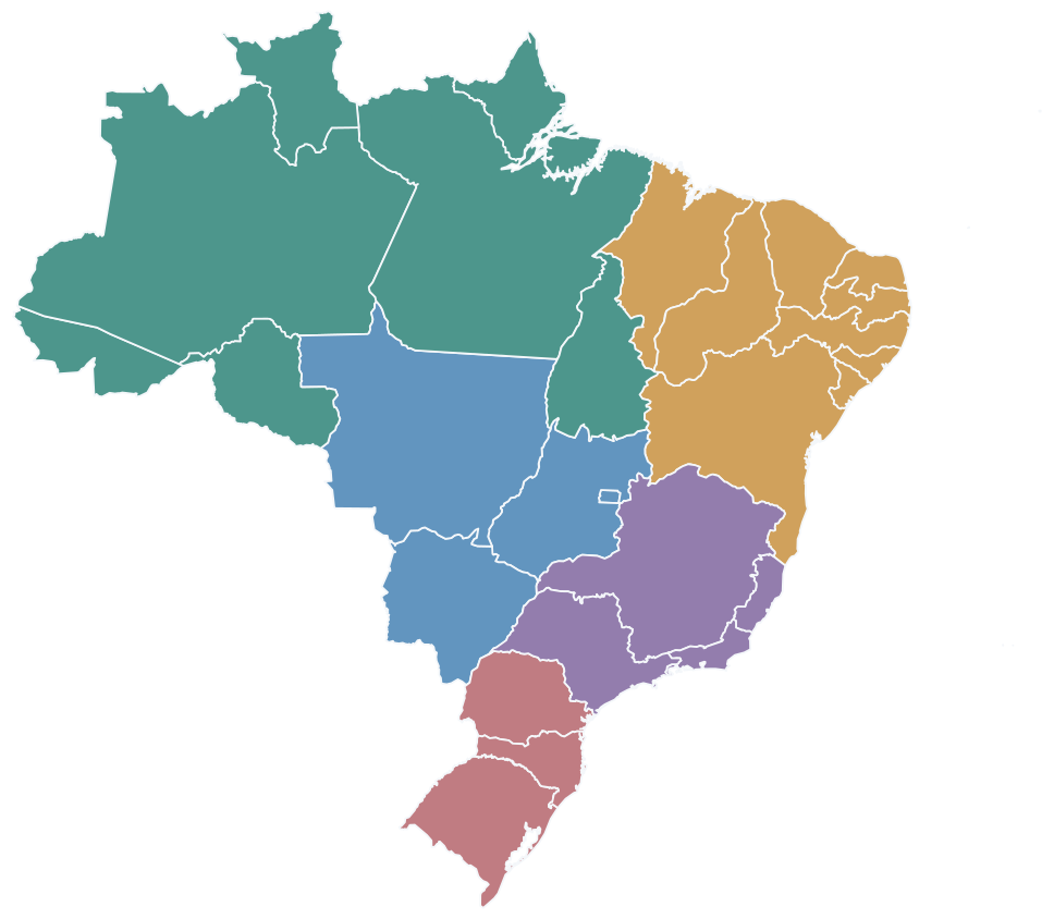
Map of Brazil with all 26 states and the Federal District colored by the five IBGE geographic regions.
  • North
  • Northeast
  • Central-West
  • Southeast
  • South
Source: IBGE · Geographic Regions of BrazilSource: IBGE · Brazil's Five Regions

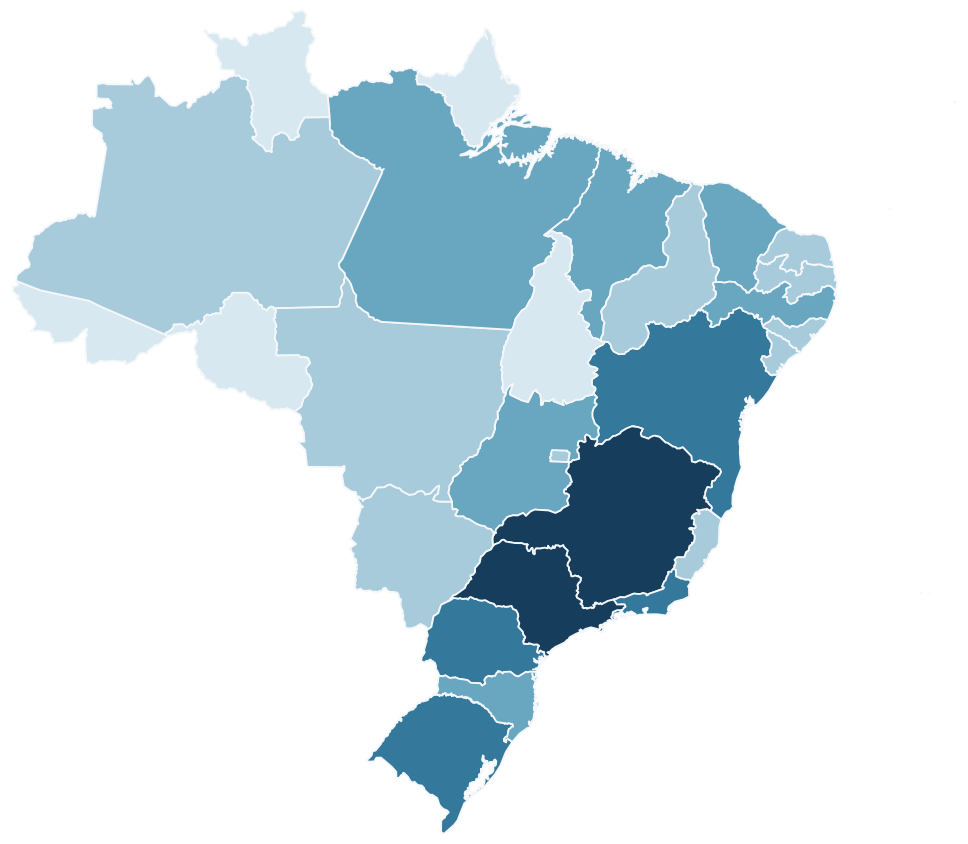
IBGE DATA / POPULATION 2026

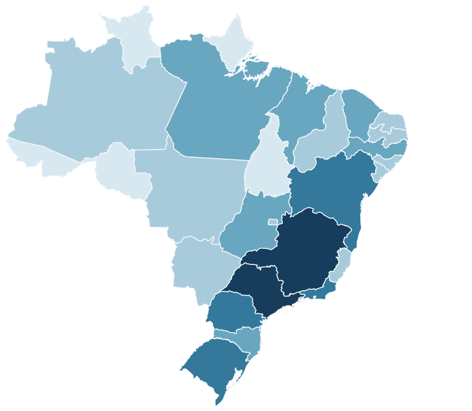
Brazil's 2026 state population estimates classified into five population ranges.
  • Under 2 million
  • 2–5 million
  • 5–10 million
  • 10–20 million
  • 20 million or more
Five population ranges · Millions of residentsRanges: <2m · 2–5m · 5–10m · 10–20m · ≥20m

IBGE DATA / POPULATION 2026IBGE DATA

Compare the Population of Brazil's StatesPopulation by State in 2026

Explore population differences across Brazil's 26 states and Federal District with a map organized into color-coded ranges.Compare Brazil's 27 federal units by estimated population.

IBGE population estimates show how Brazil's population is distributed across the country. Group states into ranges and highlight regional differences in a clear visualization.Estimates for July 1, 2026 for all 26 states and the Federal District.

214.2 million214.2 million

Estimate for July 1, 2026 · Source: IBGESource: IBGE · 2026 Population Estimates

Create a Population MapCreate a Population Map

GET STARTEDHOW IT WORKS

How to Color Brazil's States on a MapHow to Color Brazil's States

Choose your colors, color each state, create categories, and add a legend. Then download your customized Brazil map as a PNG.

  1. 01

    Open the Brazil MapOpen

    Open the editor with all 26 states and the Federal District ready to customize.Choose a map with 27 editable areas.

  2. 02

    Color the StatesColor

    Click individual areas to choose colors and organize categories.Click states and create categories.

  3. 03

    Add ContextExplain

    Include a title, legend, and data source.Add a title, legend, and source.

  4. 04

    Download Your MapDownload

    Export your finished map as a PNG for presentations, reports, or personal projects.Export the finished map as a PNG.

CUSTOMIZE YOUR MAPFEATURES

Your Brazil Map, Your Way.Customize Every Detail.

Color Every StateColor Each State

Choose different colors for Brazil's 26 states and Federal District.Choose your preferred colors.

Categories and LegendsCategories and Legends

Organize areas by color and explain what each category represents.Explain what the colors mean.

Titles and SourcesTitle and Source

Add information that helps readers understand your map.Add context to your map.

Map StylesMap Styles

Choose a minimalist or editorial presentation for your project.Choose an editorial presentation.

Data VisualizationCompare Data

Compare indicators and highlight differences between states and regions.Organize indicators by state.

High-Resolution PNGPNG Export

Download an image ready for presentations, reports, and publications.Download and share your map.

GEOGRAPHIC COVERAGEABOUT THE MAP

26 States. One Federal District.26 States. One Federal District.

The map includes all 27 federal units of Brazil, with 26 states and the Federal District available for individual customization.All 27 federal units can be colored individually.

WHAT'S INCLUDED

27 Editable Areas

Brazil is divided into five geographic regions: North, Northeast, Central-West, Southeast, and South.The Federal District is not a state. Municipalities are not individually selectable.

The Federal District is a federal unit, but it is not a state.

BRAZIL'S FIVE REGIONSBRAZIL'S FIVE REGIONS

Explore the States in Each Region of BrazilStates in Each Region of Brazil

Discover Brazil's geographic regions and the states that make up each of the country's five official macroregions.Explore the five regions and their 27 federal units.

North

7 states

  • Acre
  • Amapá
  • Amazonas
  • Pará
  • Rondônia
  • Roraima
  • Tocantins

Northeast

9 states

  • Alagoas
  • Bahia
  • Ceará
  • Maranhão
  • Paraíba
  • Pernambuco
  • Piauí
  • Rio Grande do Norte
  • Sergipe

Central-West

3 states + Federal District

  • Federal District
  • Goiás
  • Mato Grosso
  • Mato Grosso do Sul

Southeast

4 states

  • Espírito Santo
  • Minas Gerais
  • Rio de Janeiro
  • São Paulo

South

3 states

  • Paraná
  • Rio Grande do Sul
  • Santa Catarina

FREQUENTLY ASKED QUESTIONSFREQUENTLY ASKED QUESTIONS

Questions About Brazil MapsQuestions About Brazil Maps

How can I color Brazil's states on a map?Can I color individual states?

Open MapSculpt's editable Brazil map, choose your colors, and click the states you want to color. You can also organize areas into categories and add a legend.Yes. Choose a color for each state.

How many states does Brazil have?How many states are there?

Brazil has 26 states and one Federal District, making 27 federal units. All are included in MapSculpt's Brazil map.26 states and the Federal District.

Can I create a customized map of Brazil?Can I customize the map?

Yes. You can choose colors for individual states, create categories, add a title and legend, and customize the result for your project.Yes. Change colors, titles, and categories.

How can I make a map of Brazil's regions?Can I color by region?

You can use different colors to represent Brazil's five regions: North, Northeast, Central-West, Southeast, and South.Yes. Use the five IBGE regions.

Can I visualize statistics by state?Can I visualize data?

Yes. Assign colors to states based on your data and create a legend to explain the categories.Yes. Classify states and add a legend.

Can I download my Brazil map as a PNG?Can I download the map as a PNG?

Yes. Once you've customized your map, you can download it as a PNG for presentations, reports, or other projects.Yes. Export your map as a ready-to-use image.

Can I create maps for r/MapPorn, r/dataisbeautiful, r/europe and other Reddit communities?Can I create maps for r/MapPorn, r/dataisbeautiful, r/europe and other Reddit communities?

Yes. MapSculpt lets you create custom maps for data visualizations, geographic comparisons and original map posts. You can color countries or regions using, for example, Eurostat data or other official sources, add a clear title, legend and source, and download your map as a high-resolution PNG. For communities such as r/MapPorn, r/dataisbeautiful, r/europe and other subreddits, use accurate data, explain your methodology where needed, and check each community’s posting rules before submitting.Yes. MapSculpt lets you create custom maps for data visualizations, geographic comparisons and original map posts. You can color countries or regions using, for example, Eurostat data or other official sources, add a clear title, legend and source, and download your map as a high-resolution PNG. For communities such as r/MapPorn, r/dataisbeautiful, r/europe and other subreddits, use accurate data, explain your methodology where needed, and check each community’s posting rules before submitting.

READY TO GET STARTED?YOUR MAP STARTS HERE

Create Your Own Brazil Map.Create a Brazil Map.

Color all 26 states and the Federal District, customize the legend, and download your map as a PNG.Color, customize, and download your map as a PNG.

Create a Brazil Map