Skip to content
MapSculpt

GEOGRAPHIC MAP MAKER / NEBRASKA

Nebraska
Counties Map Maker

Compare household income estimates across Nebraska, from the Omaha area to the Panhandle. Use the population and migration maps to consider how county size changes a comparison.

Free online editor · No sign-up required

93counties
individually editable

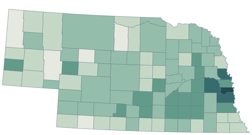
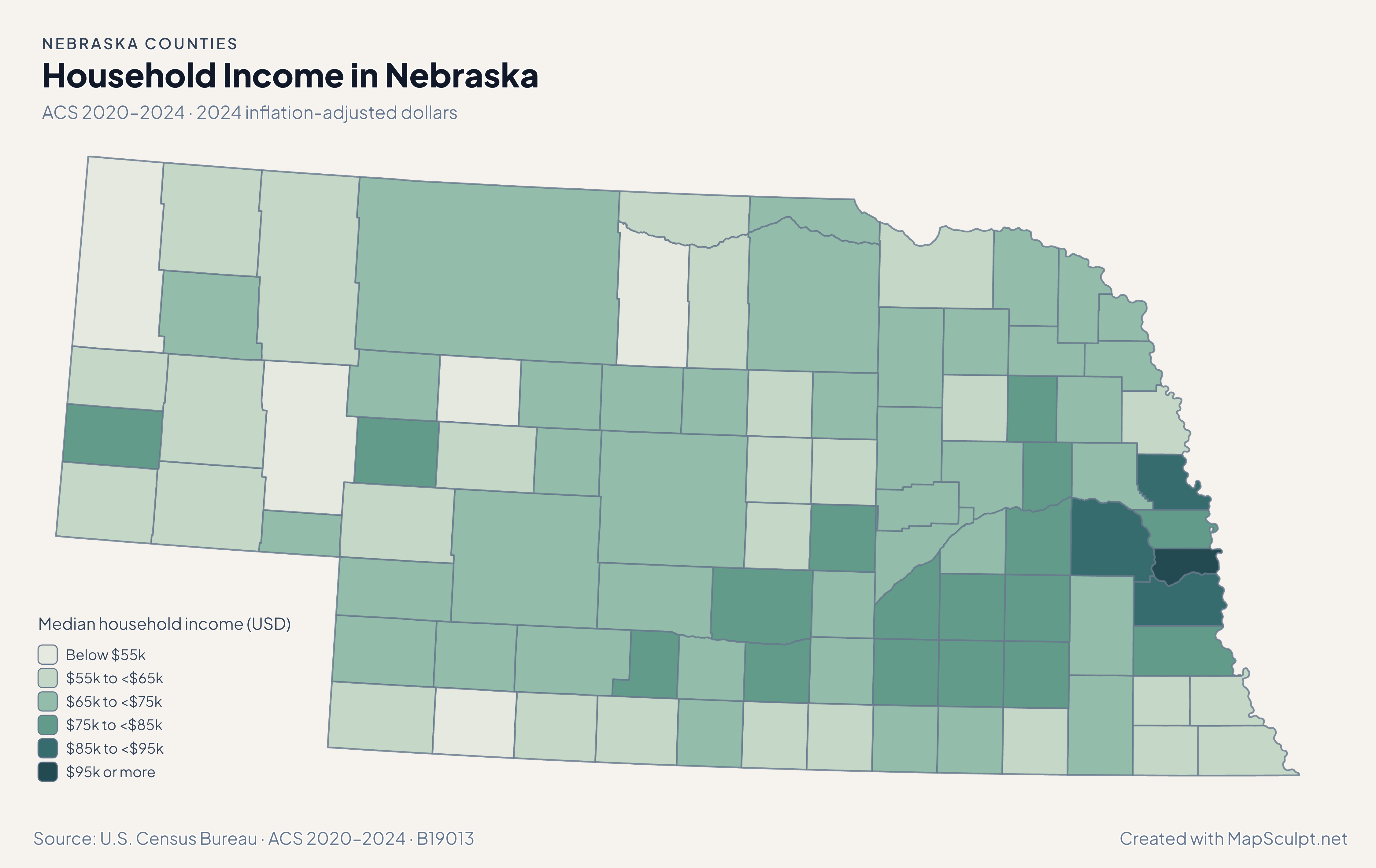
Household Income in Nebraska

ACS 2020–2024 · 2024 inflation-adjusted dollars

Nebraska county choropleth of household income, including Sarpy, Douglas, Lancaster.

Median household income (USD)

  • Below $55k
  • $55k to <$65k
  • $65k to <$75k
  • $75k to <$85k
  • $85k to <$95k
  • $95k or more
U.S. Census Bureau · ACS 2020–2024 · B19013Download complete PNG Household medians are reported in 2024 inflation-adjusted dollars.

KNOW YOUR GEOGRAPHY

County geography from the Missouri River to the Panhandle

Nebraska has 93 selectable counties across the Missouri River corridor, the central Platte country, the Sandhills and the western Panhandle.

Omaha and Lincoln are cities. For county estimates use Douglas and Lancaster where appropriate, and retain the full state-prefixed GEOID in joins.

Browse all county GEOIDs ↗

2025 Census boundaries

OFFICIAL DATA

Omaha, Lincoln and the counties farther west

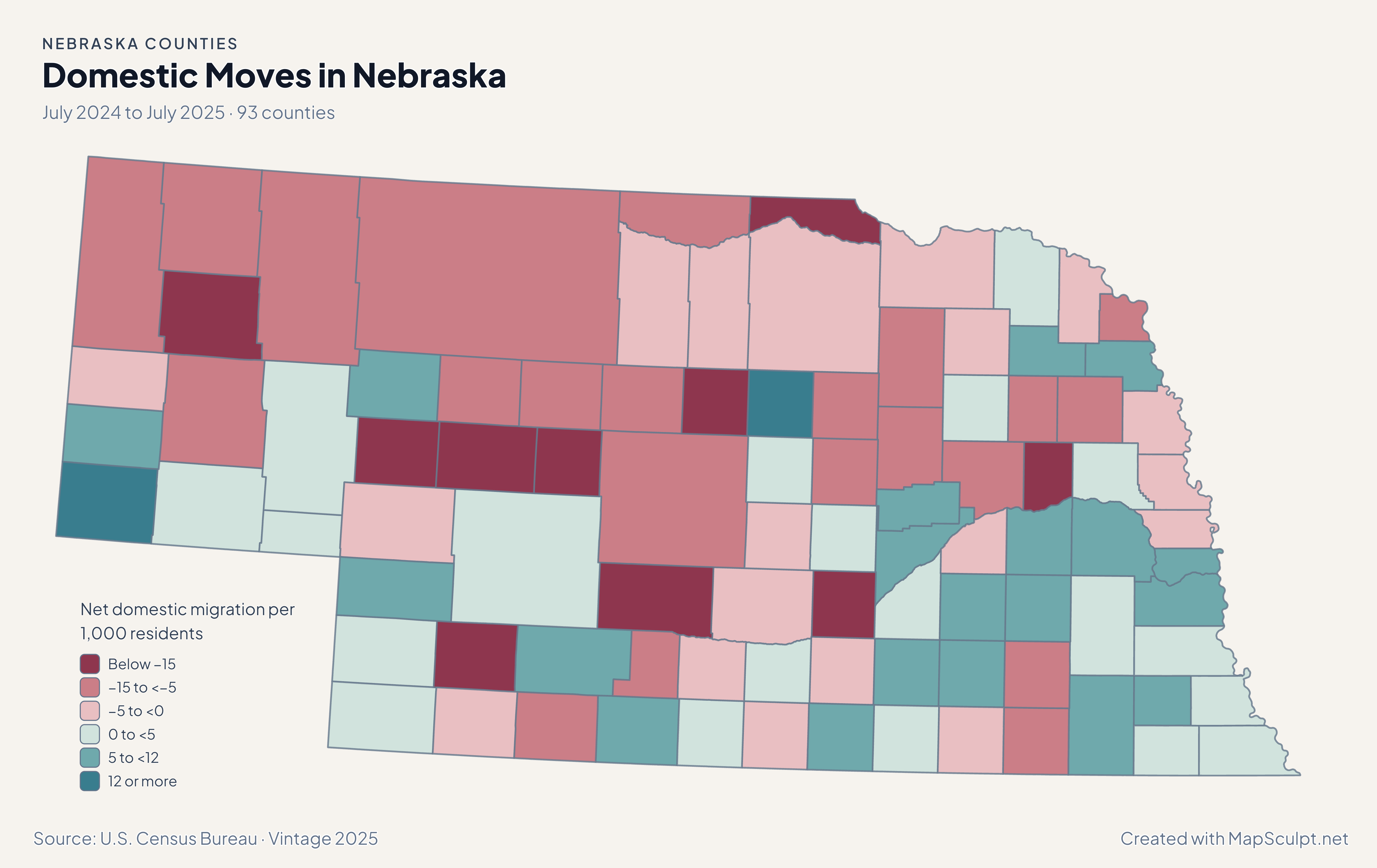
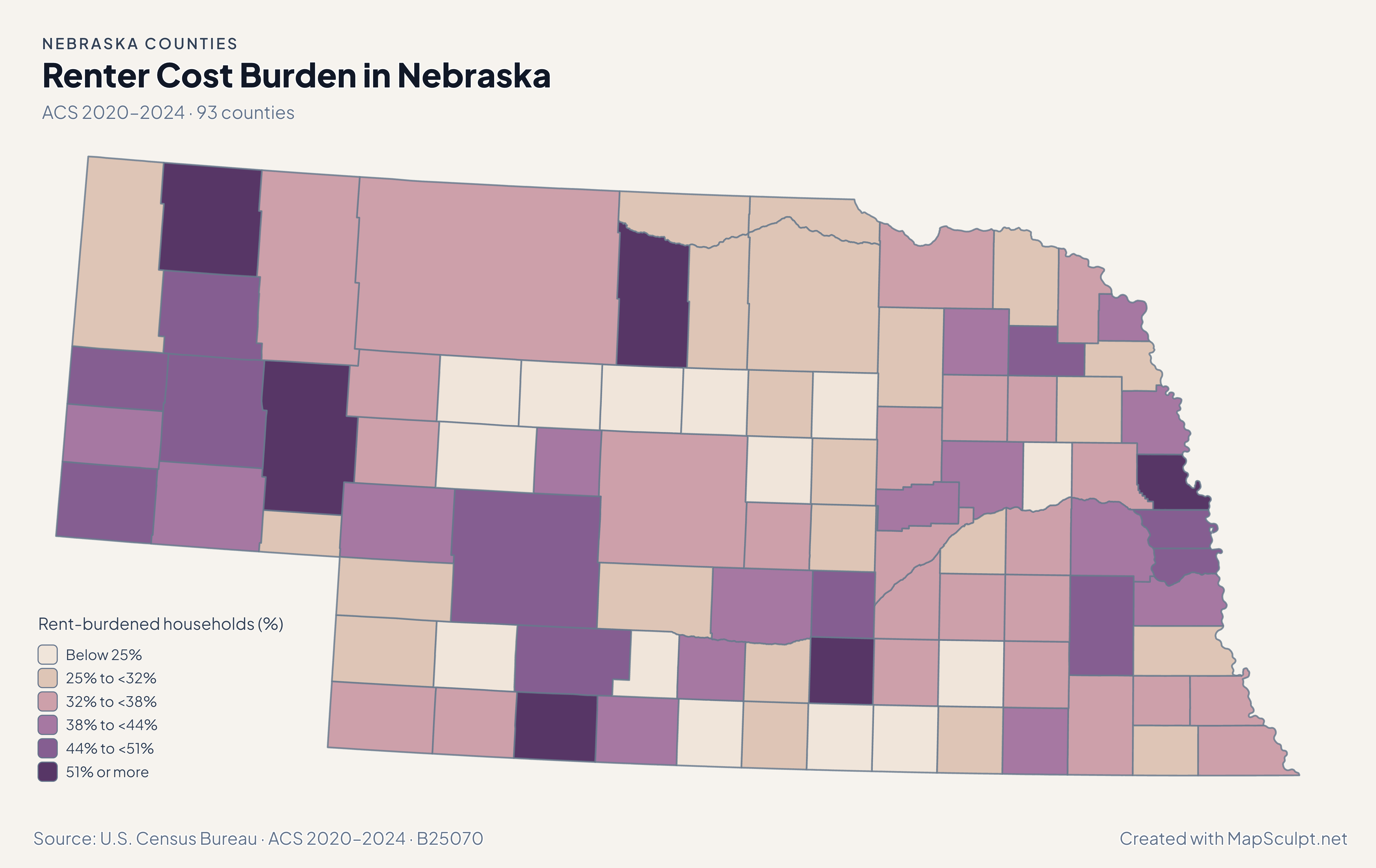
Population and net domestic moves compare July 2024 and July 2025. Household income and renter costs use the 2020–2024 American Community Survey.

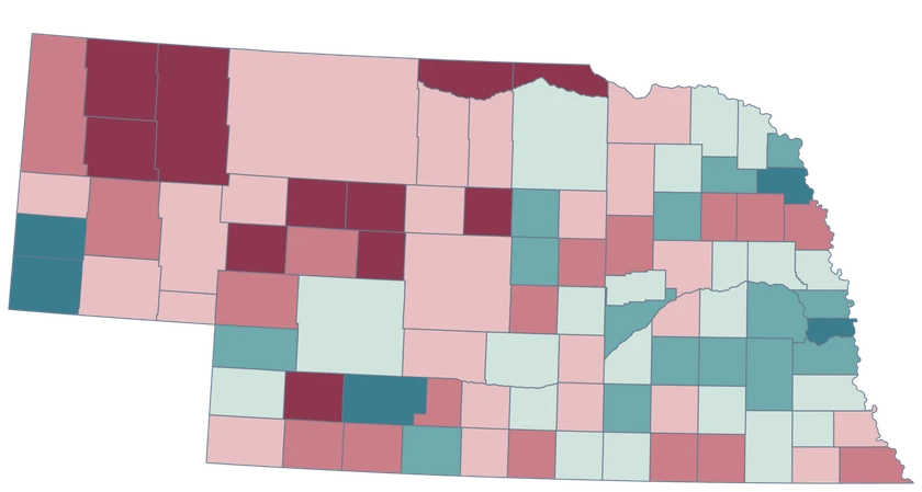
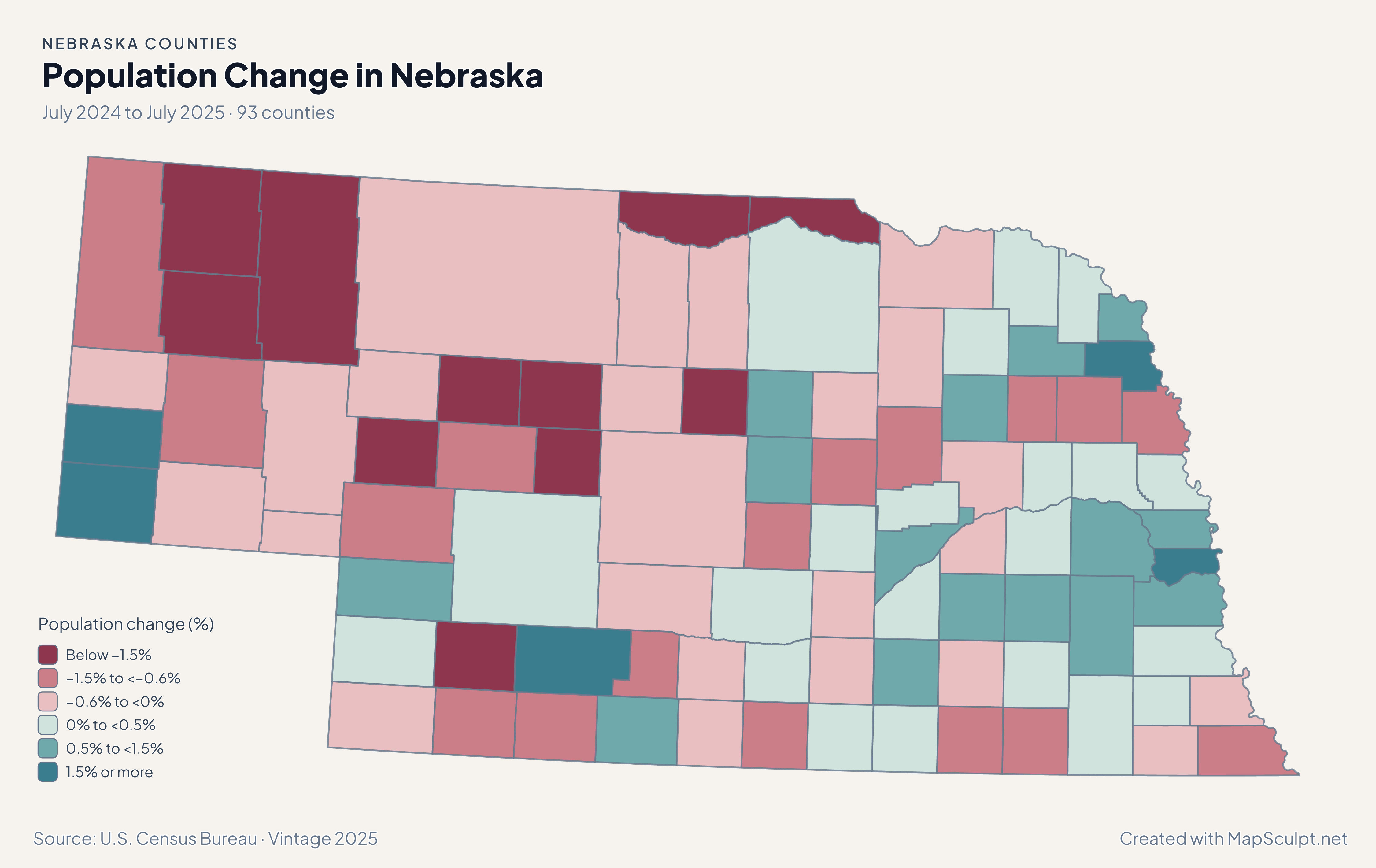
Nebraska county choropleth of population change, including Sarpy, Douglas, Arthur.

July 2024 to July 2025 · 93 counties

A large rate and a large change are different comparisons.

Sarpy grew 1.85%, while Douglas grew 0.93%. Arthur declined 5.04%. In small counties a pronounced rate can represent a relatively small headcount. Refer to the Census totals when comparing absolute changes.

Population change (%)

  • Below −1.5%
  • −1.5% to <−0.6%
  • −0.6% to <0%
  • 0% to <0.5%
  • 0.5% to <1.5%
  • 1.5% or more

U.S. Census Bureau · Vintage 2025

Download complete PNG

Estimated median household income was $103,321 in Sarpy, $80,391 in Douglas, and $74,793 in Lancaster. These are county-wide ACS estimates in 2024 dollars. See the Census estimates ↗

MAKE IT YOURS

From county data to a finished map.

  1. Open the Nebraska editor

    Start with all 93 county features.

  2. Match county records

    Use the five-digit GEOID, such as 31055. Review matches before applying a color scale.

  3. Classify by measurement

    Choose intervals and colors that make the units and direction of change easy to read.

  4. Export the finished map

    Include the source, period and legend in a downloadable PNG.

TRY CSV IMPORT

Try six Nebraska records.

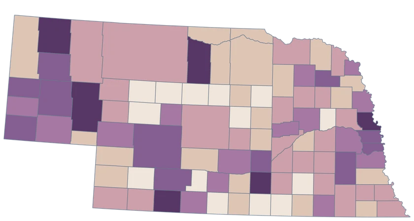
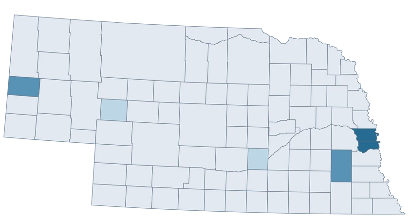
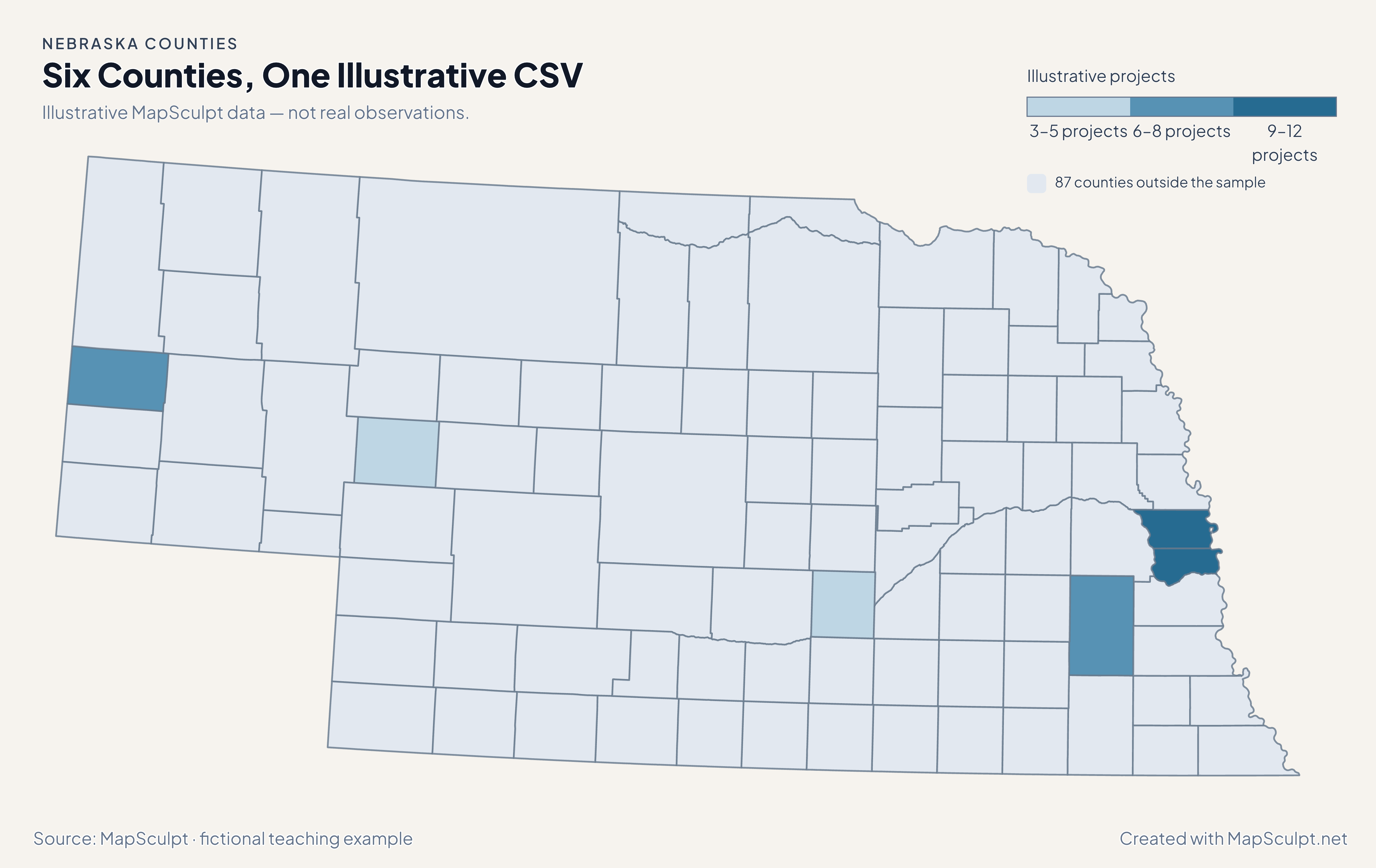
Import the fictional project counts and use breaks of 3, 6, 9 and 12. The remaining 87 counties stay neutral.

Illustrative MapSculpt data — not real observations.
CountyGEOIDProjects
Douglas County3105512
Sarpy County311539
Lancaster County311097
Hall County310793
Scotts Bluff County311578
Arthur County310055

Keep five-digit GEOIDs as text. The sample uses 31055 for Douglas County.

Download illustrative CSV ↓

Six Counties, One Illustrative CSV

Illustrative MapSculpt data — not real observations.

Nebraska example map with six fictional project counts and 87 neutral counties.

Illustrative projects

  • 3–5 projects
  • 6–8 projects
  • 9–12 projects
  • 87 counties outside the sample
Download complete PNG

CSV → Match 6 counties → Style → Export PNG Create a Nebraska map

COUNTY REFERENCE

All 93 Nebraska counties and GEOIDs.

Official county names and five-digit Census GEOIDs. Search by name or code.

  1. Adams CountyGEOID 31001
  2. Antelope CountyGEOID 31003
  3. Arthur CountyGEOID 31005
  4. Banner CountyGEOID 31007
  5. Blaine CountyGEOID 31009
  6. Boone CountyGEOID 31011
  7. Box Butte CountyGEOID 31013
  8. Boyd CountyGEOID 31015
  9. Brown CountyGEOID 31017
  10. Buffalo CountyGEOID 31019
  11. Burt CountyGEOID 31021
  12. Butler CountyGEOID 31023
  13. Cass CountyGEOID 31025
  14. Cedar CountyGEOID 31027
  15. Chase CountyGEOID 31029
  16. Cherry CountyGEOID 31031
  17. Cheyenne CountyGEOID 31033
  18. Clay CountyGEOID 31035
  19. Colfax CountyGEOID 31037
  20. Cuming CountyGEOID 31039
  21. Custer CountyGEOID 31041
  22. Dakota CountyGEOID 31043
  23. Dawes CountyGEOID 31045
  24. Dawson CountyGEOID 31047
  25. Deuel CountyGEOID 31049
  26. Dixon CountyGEOID 31051
  27. Dodge CountyGEOID 31053
  28. Douglas CountyGEOID 31055
  29. Dundy CountyGEOID 31057
  30. Fillmore CountyGEOID 31059
  31. Franklin CountyGEOID 31061
  32. Frontier CountyGEOID 31063
  33. Furnas CountyGEOID 31065
  34. Gage CountyGEOID 31067
  35. Garden CountyGEOID 31069
  36. Garfield CountyGEOID 31071
  37. Gosper CountyGEOID 31073
  38. Grant CountyGEOID 31075
  39. Greeley CountyGEOID 31077
  40. Hall CountyGEOID 31079
  41. Hamilton CountyGEOID 31081
  42. Harlan CountyGEOID 31083
  43. Hayes CountyGEOID 31085
  44. Hitchcock CountyGEOID 31087
  45. Holt CountyGEOID 31089
  46. Hooker CountyGEOID 31091
  47. Howard CountyGEOID 31093
  48. Jefferson CountyGEOID 31095
  49. Johnson CountyGEOID 31097
  50. Kearney CountyGEOID 31099
  51. Keith CountyGEOID 31101
  52. Keya Paha CountyGEOID 31103
  53. Kimball CountyGEOID 31105
  54. Knox CountyGEOID 31107
  55. Lancaster CountyGEOID 31109
  56. Lincoln CountyGEOID 31111
  57. Logan CountyGEOID 31113
  58. Loup CountyGEOID 31115
  59. Madison CountyGEOID 31119
  60. McPherson CountyGEOID 31117
  61. Merrick CountyGEOID 31121
  62. Morrill CountyGEOID 31123
  63. Nance CountyGEOID 31125
  64. Nemaha CountyGEOID 31127
  65. Nuckolls CountyGEOID 31129
  66. Otoe CountyGEOID 31131
  67. Pawnee CountyGEOID 31133
  68. Perkins CountyGEOID 31135
  69. Phelps CountyGEOID 31137
  70. Pierce CountyGEOID 31139
  71. Platte CountyGEOID 31141
  72. Polk CountyGEOID 31143
  73. Red Willow CountyGEOID 31145
  74. Richardson CountyGEOID 31147
  75. Rock CountyGEOID 31149
  76. Saline CountyGEOID 31151
  77. Sarpy CountyGEOID 31153
  78. Saunders CountyGEOID 31155
  79. Scotts Bluff CountyGEOID 31157
  80. Seward CountyGEOID 31159
  81. Sheridan CountyGEOID 31161
  82. Sherman CountyGEOID 31163
  83. Sioux CountyGEOID 31165
  84. Stanton CountyGEOID 31167
  85. Thayer CountyGEOID 31169
  86. Thomas CountyGEOID 31171
  87. Thurston CountyGEOID 31173
  88. Valley CountyGEOID 31175
  89. Washington CountyGEOID 31177
  90. Wayne CountyGEOID 31179
  91. Webster CountyGEOID 31181
  92. Wheeler CountyGEOID 31183
  93. York CountyGEOID 31185

U.S. Census Bureau · 2025 Cartographic Boundary Files

COMMON QUESTIONS

Nebraska county map questions.

Which GEOID identifies Douglas County, Nebraska?

Use 31055. Other states have a Douglas County too, so retain the 31 state prefix.

Do Omaha and Lincoln have their own county polygons?

The map shows county units. Use Douglas County and Lancaster County only when your records describe those counties.

Can I compare counties along the Platte River?

Choose the counties covered by your dataset. The river corridor is not a separate selectable unit in this layer.

Why can a small county have an intense change color?

The change is a percentage of its starting population. Compare the county counts when the number of residents matters.

Can I distinguish the Sandhills from the Panhandle?

You can style the relevant counties independently or group them with your own colors and legend. They are not pre-defined Census county groups.

Do rent burden and income describe the same households?

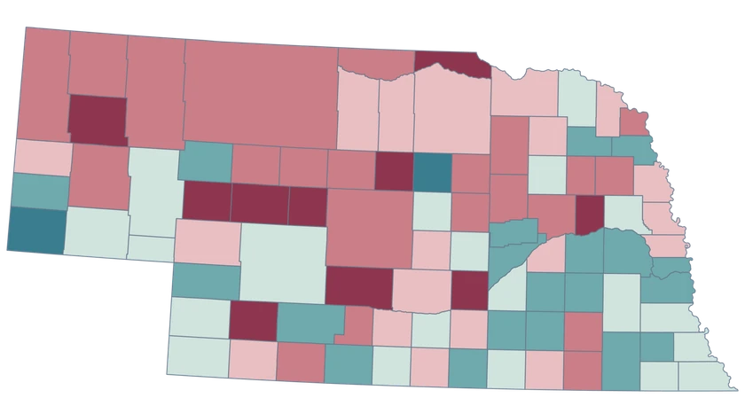
The income estimate covers households broadly. Rent burden here covers renter households with computable gross rent-to-income ratios.

YOUR NEXT MAP STARTS HERE

Build your Nebraska county map.

Join your own Nebraska county records by GEOID, review the matches and export with an accurate legend.

Create a Nebraska map