Skip to content
MapSculpt

GEOGRAPHIC MAP MAKER / MISSOURI

Missouri
Counties Map Maker

Compare domestic moves across the St. Louis region, western Missouri and the Ozarks. St. Louis city has its own Census shape and GEOID beside the county of the same name.

Free online editor · No sign-up required

115county-level units
individually editable

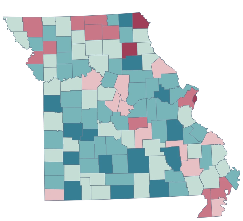
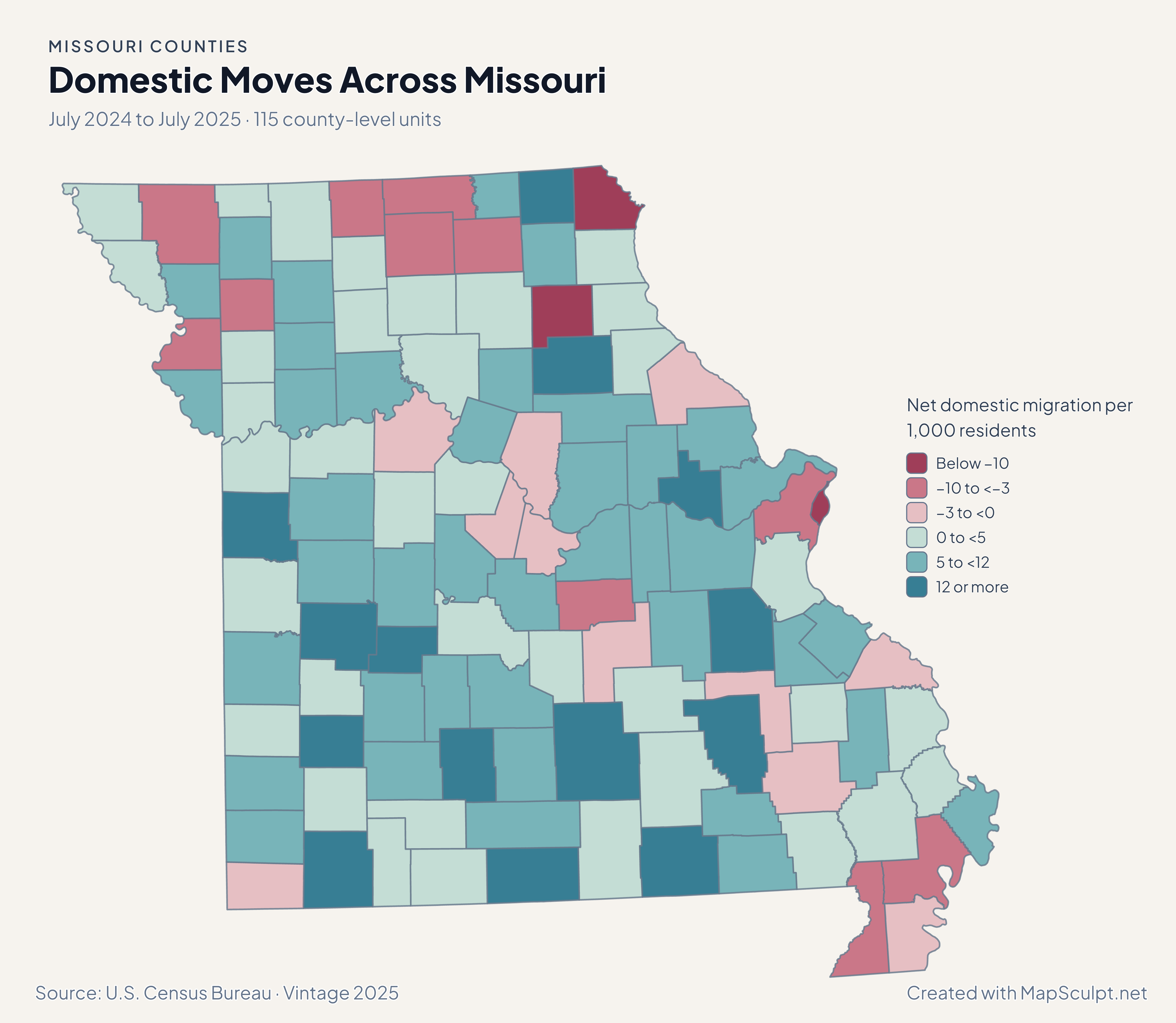
Domestic Moves Across Missouri

July 2024 to July 2025 · 115 county-level units

Missouri net domestic migration map with separate fills around St. Louis and high rates in parts of southwest Missouri.

Net domestic migration per 1,000 residents

  • Below −10
  • −10 to <−3
  • −3 to <0
  • 0 to <5
  • 5 to <12
  • 12 or more
U.S. Census Bureau · Vintage 2025Download complete PNG Net domestic moves within the United States, per 1,000 residents.

KNOW YOUR GEOGRAPHY

114 counties and the independent city of St. Louis

The county map includes 114 counties plus St. Louis city, a separate Census county equivalent. The city is GEOID 29510 and St. Louis County is 29189. Each retains its own shape, fill and matching identity.

The map spans the Missouri and Mississippi river corridors, the Ozarks and the Bootheel. Use generalized county boundaries to compare the same measure across these areas.

Browse all county GEOIDs ↗

2025 Census boundaries

OFFICIAL DATA

Separate city and county identities reveal different rates.

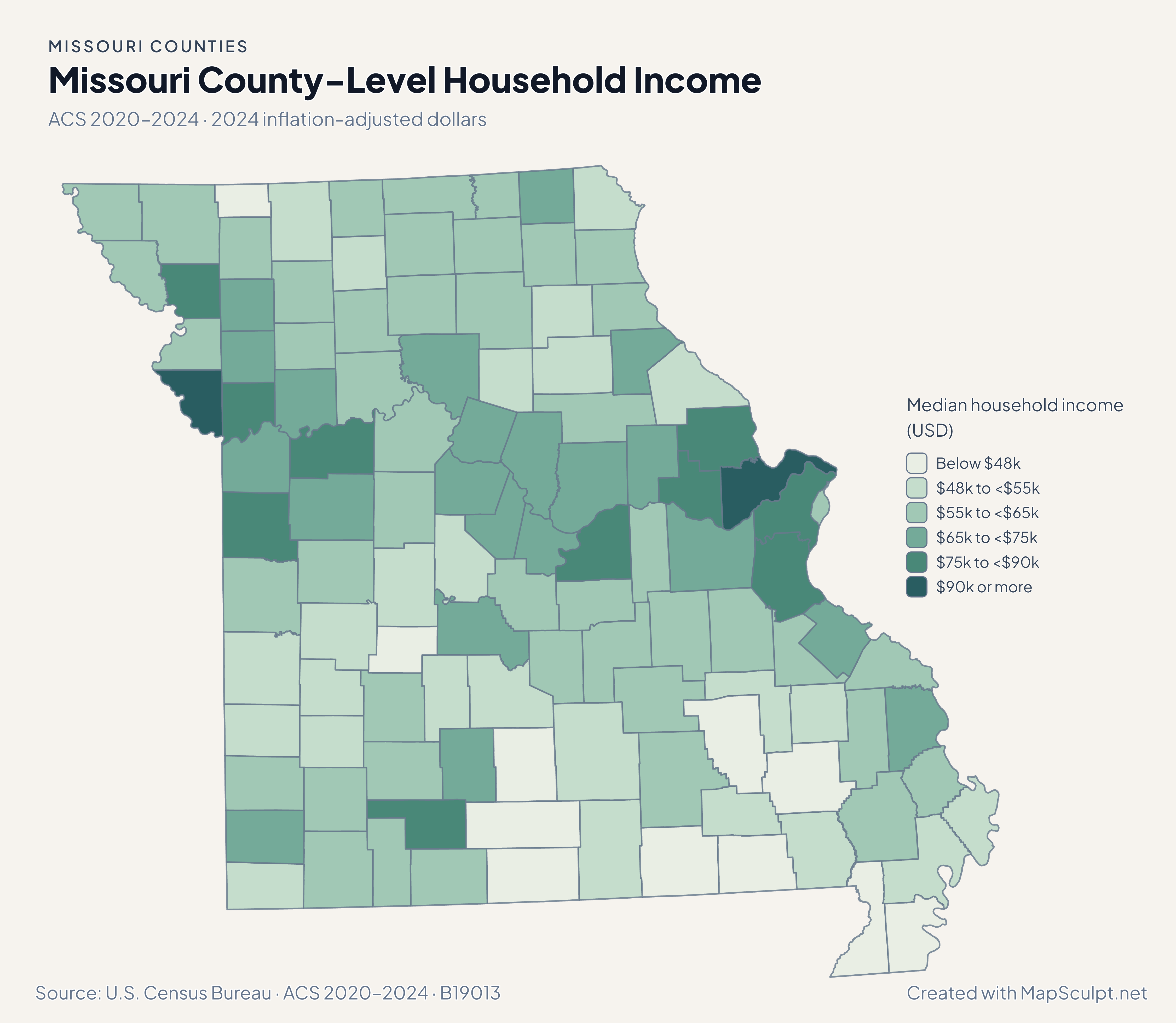
Keep St. Louis city and county separate when comparing growth, domestic moves and household estimates.

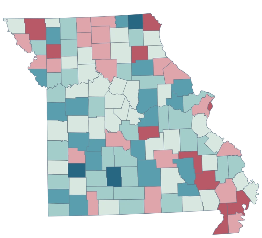
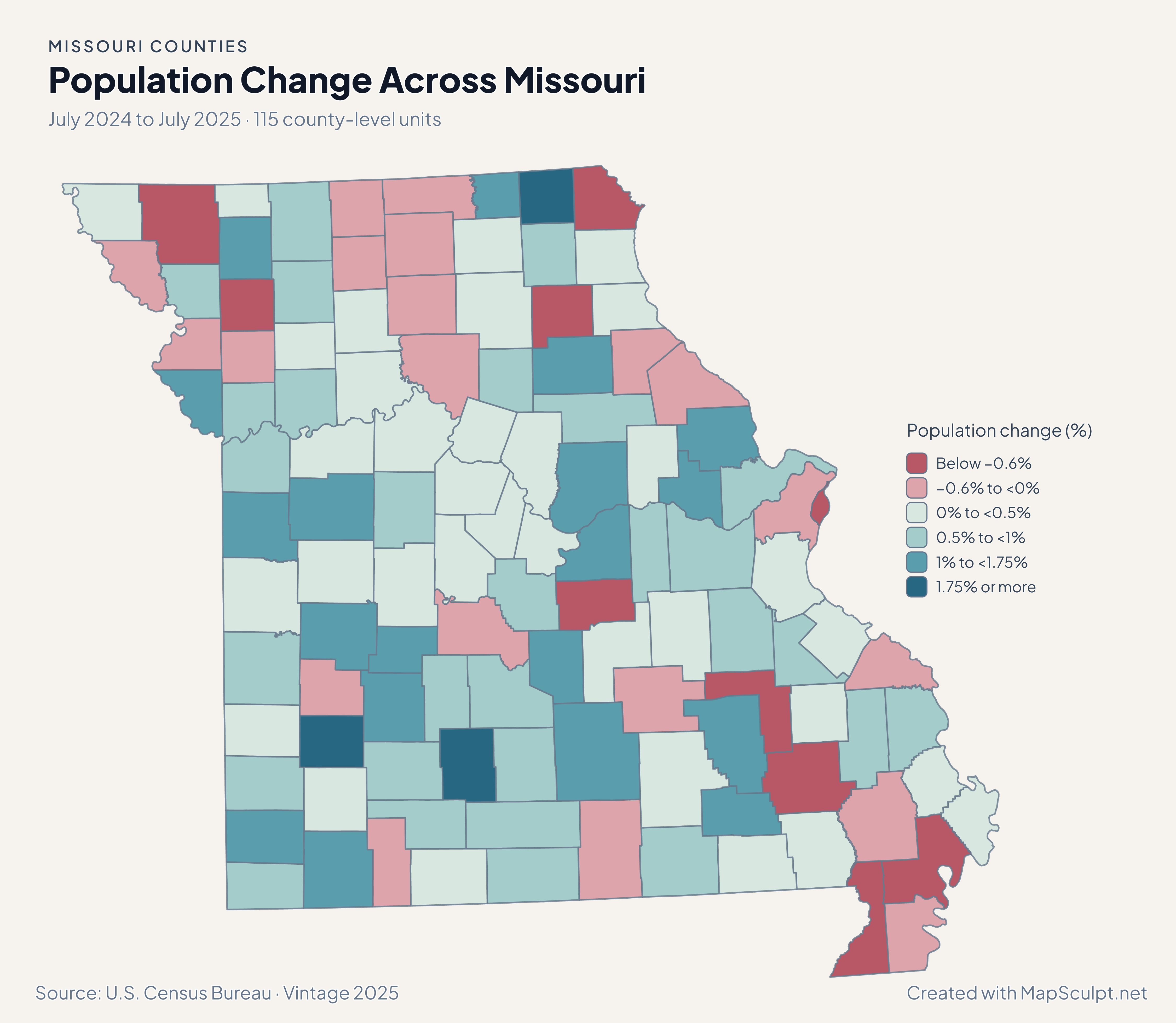
Missouri population change map with separate loss shades in St. Louis city and county and a gain in St. Charles.

July 2024 to July 2025 · 115 county-level units

The city, county and their neighbors changed at different rates

St. Louis city declined 0.82%, St. Louis County declined 0.08%, and St. Charles County grew 0.93%.

Population change (%)

  • Below −0.6%
  • −0.6% to <0%
  • 0% to <0.5%
  • 0.5% to <1%
  • 1% to <1.75%
  • 1.75% or more

U.S. Census Bureau · Vintage 2025

Download complete PNG

St. Louis city recorded −13.42 net domestic movers per 1,000, compared with −3.40 in St. Louis County. In the west, Platte recorded 6.05; in southwest Missouri, Dade led at 30.69. See the Census estimates ↗

MAKE IT YOURS

From county data to a finished map.

  1. Open the Missouri editor

    Start with all 115 county-level units.

  2. Match your data by GEOID

    Keep GEOIDs as text. The example uses St. Louis city, 29510, and five other official county-level records.

  3. Explain what the colors measure

    Set class breaks, add the reference period, and include a legend and source.

  4. Download the complete map

    Check small features and labels, then export the finished high-resolution PNG.

TRY CSV IMPORT

Practice joining six official GEOIDs.

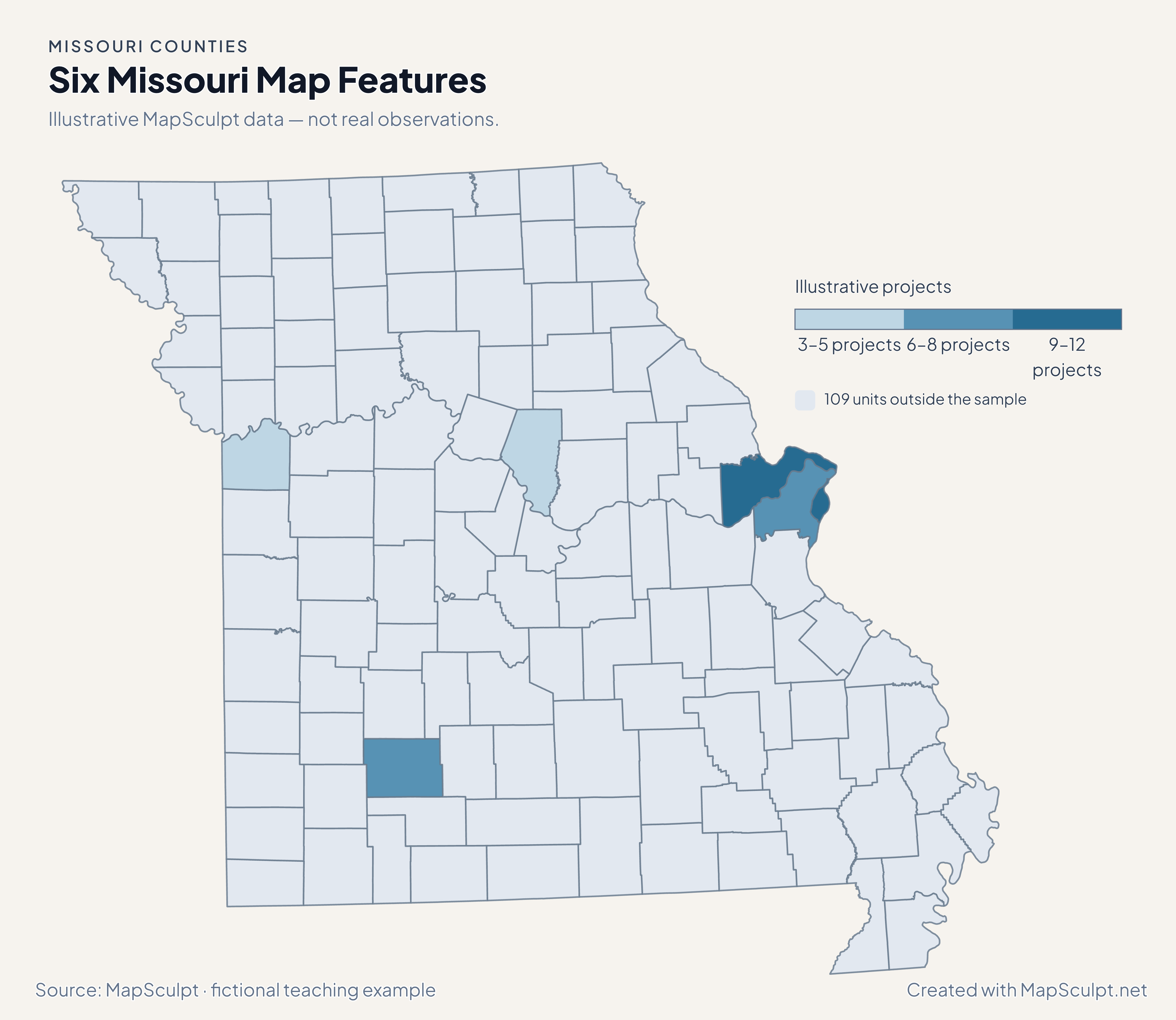
Import the fictional project counts and choose numeric boundaries of 3, 6, 9 and 12. The other 109 county-level units use a neutral fill.

Illustrative MapSculpt data — not real observations.
CountyGEOIDProjects
St. Louis city2951012
St. Louis County291896
St. Charles County291839
Jackson County290953
Greene County290777
Boone County290195

Keep GEOIDs as text. The example uses St. Louis city, 29510, and five other official county-level records.

Download illustrative CSV ↓

Six Missouri Map Features

Illustrative MapSculpt data — not real observations.

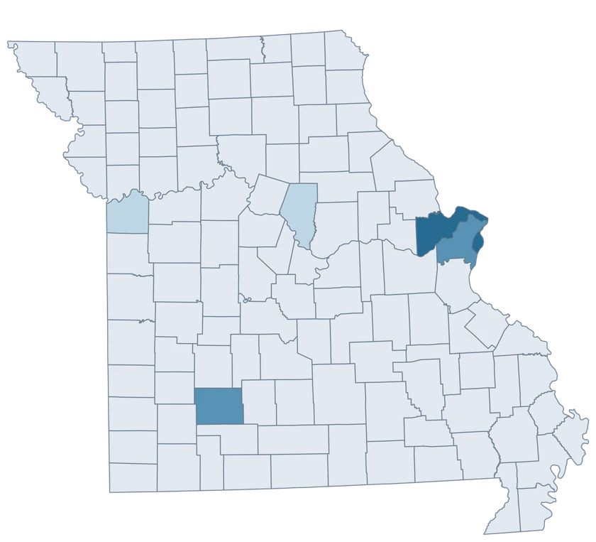
Illustrative Missouri project map identifying six features and leaving 109 neutral.

Illustrative projects

  • 3–5 projects
  • 6–8 projects
  • 9–12 projects
  • 109 units outside the sample
Download complete PNG

CSV → Match 6 county-level units → Style → Export PNG Create a Missouri map

GEOGRAPHY NOTES

St. Louis city keeps a separate Census identity

The Census Bureau includes independent St. Louis city at county level. Keep the city and county on separate rows in a source table, especially when a dataset abbreviates both labels. The directory and illustrative CSV use the official identifiers.

U.S. Census Bureau · TIGER/Line technical documentation

COUNTY REFERENCE

Find all 115 Missouri county-level units and GEOIDs.

Official county and independent city names and five-digit Census GEOIDs. Search by name or code.

  1. Adair CountyGEOID 29001
  2. Andrew CountyGEOID 29003
  3. Atchison CountyGEOID 29005
  4. Audrain CountyGEOID 29007
  5. Barry CountyGEOID 29009
  6. Barton CountyGEOID 29011
  7. Bates CountyGEOID 29013
  8. Benton CountyGEOID 29015
  9. Bollinger CountyGEOID 29017
  10. Boone CountyGEOID 29019
  11. Buchanan CountyGEOID 29021
  12. Butler CountyGEOID 29023
  13. Caldwell CountyGEOID 29025
  14. Callaway CountyGEOID 29027
  15. Camden CountyGEOID 29029
  16. Cape Girardeau CountyGEOID 29031
  17. Carroll CountyGEOID 29033
  18. Carter CountyGEOID 29035
  19. Cass CountyGEOID 29037
  20. Cedar CountyGEOID 29039
  21. Chariton CountyGEOID 29041
  22. Christian CountyGEOID 29043
  23. Clark CountyGEOID 29045
  24. Clay CountyGEOID 29047
  25. Clinton CountyGEOID 29049
  26. Cole CountyGEOID 29051
  27. Cooper CountyGEOID 29053
  28. Crawford CountyGEOID 29055
  29. Dade CountyGEOID 29057
  30. Dallas CountyGEOID 29059
  31. Daviess CountyGEOID 29061
  32. DeKalb CountyGEOID 29063
  33. Dent CountyGEOID 29065
  34. Douglas CountyGEOID 29067
  35. Dunklin CountyGEOID 29069
  36. Franklin CountyGEOID 29071
  37. Gasconade CountyGEOID 29073
  38. Gentry CountyGEOID 29075
  39. Greene CountyGEOID 29077
  40. Grundy CountyGEOID 29079
  41. Harrison CountyGEOID 29081
  42. Henry CountyGEOID 29083
  43. Hickory CountyGEOID 29085
  44. Holt CountyGEOID 29087
  45. Howard CountyGEOID 29089
  46. Howell CountyGEOID 29091
  47. Iron CountyGEOID 29093
  48. Jackson CountyGEOID 29095
  49. Jasper CountyGEOID 29097
  50. Jefferson CountyGEOID 29099
  51. Johnson CountyGEOID 29101
  52. Knox CountyGEOID 29103
  53. Laclede CountyGEOID 29105
  54. Lafayette CountyGEOID 29107
  55. Lawrence CountyGEOID 29109
  56. Lewis CountyGEOID 29111
  57. Lincoln CountyGEOID 29113
  58. Linn CountyGEOID 29115
  59. Livingston CountyGEOID 29117
  60. Macon CountyGEOID 29121
  61. Madison CountyGEOID 29123
  62. Maries CountyGEOID 29125
  63. Marion CountyGEOID 29127
  64. McDonald CountyGEOID 29119
  65. Mercer CountyGEOID 29129
  66. Miller CountyGEOID 29131
  67. Mississippi CountyGEOID 29133
  68. Moniteau CountyGEOID 29135
  69. Monroe CountyGEOID 29137
  70. Montgomery CountyGEOID 29139
  71. Morgan CountyGEOID 29141
  72. New Madrid CountyGEOID 29143
  73. Newton CountyGEOID 29145
  74. Nodaway CountyGEOID 29147
  75. Oregon CountyGEOID 29149
  76. Osage CountyGEOID 29151
  77. Ozark CountyGEOID 29153
  78. Pemiscot CountyGEOID 29155
  79. Perry CountyGEOID 29157
  80. Pettis CountyGEOID 29159
  81. Phelps CountyGEOID 29161
  82. Pike CountyGEOID 29163
  83. Platte CountyGEOID 29165
  84. Polk CountyGEOID 29167
  85. Pulaski CountyGEOID 29169
  86. Putnam CountyGEOID 29171
  87. Ralls CountyGEOID 29173
  88. Randolph CountyGEOID 29175
  89. Ray CountyGEOID 29177
  90. Reynolds CountyGEOID 29179
  91. Ripley CountyGEOID 29181
  92. Saline CountyGEOID 29195
  93. Schuyler CountyGEOID 29197
  94. Scotland CountyGEOID 29199
  95. Scott CountyGEOID 29201
  96. Shannon CountyGEOID 29203
  97. Shelby CountyGEOID 29205
  98. St. Charles CountyGEOID 29183
  99. St. Clair CountyGEOID 29185
  100. St. Francois CountyGEOID 29187
  101. St. Louis cityGEOID 29510
  102. St. Louis CountyGEOID 29189
  103. Ste. Genevieve CountyGEOID 29186
  104. Stoddard CountyGEOID 29207
  105. Stone CountyGEOID 29209
  106. Sullivan CountyGEOID 29211
  107. Taney CountyGEOID 29213
  108. Texas CountyGEOID 29215
  109. Vernon CountyGEOID 29217
  110. Warren CountyGEOID 29219
  111. Washington CountyGEOID 29221
  112. Wayne CountyGEOID 29223
  113. Webster CountyGEOID 29225
  114. Worth CountyGEOID 29227
  115. Wright CountyGEOID 29229

U.S. Census Bureau · 2025 Cartographic Boundary Files

COMMON QUESTIONS

Missouri county map questions.

Is St. Louis city inside St. Louis County?

They are separate Census county-level units. Select 29510 for St. Louis city and 29189 for St. Louis County.

Why does the Missouri directory have 115 entries?

It lists all 114 counties plus independent St. Louis city.

Which GEOID should I use for a Kansas City-area figure?

Use the GEOID of the county actually observed, such as 29095 for Jackson County. A city-wide count can cross county boundaries.

Can the same CSV contain St. Louis city and county?

Yes. Use separate rows with their official GEOIDs. The fictional example includes both.

How do I map both sides of the St. Louis metropolitan area?

Use the national county editor to include Missouri and Illinois together, with each county-level GEOID preserved.

Can I label Missouri’s Bootheel as a region?

You can group and label the counties your project includes. The Census editor retains distinct county identities for those features.

YOUR NEXT MAP STARTS HERE

Give each Missouri county-level unit its own value.

Join your data by GEOID or select features by hand, then export a PNG with a useful title and source.

Create a Missouri map