Skip to content
MapSculpt

GEOGRAPHIC MAP MAKER / ARKANSAS

Arkansas
Counties Map Maker

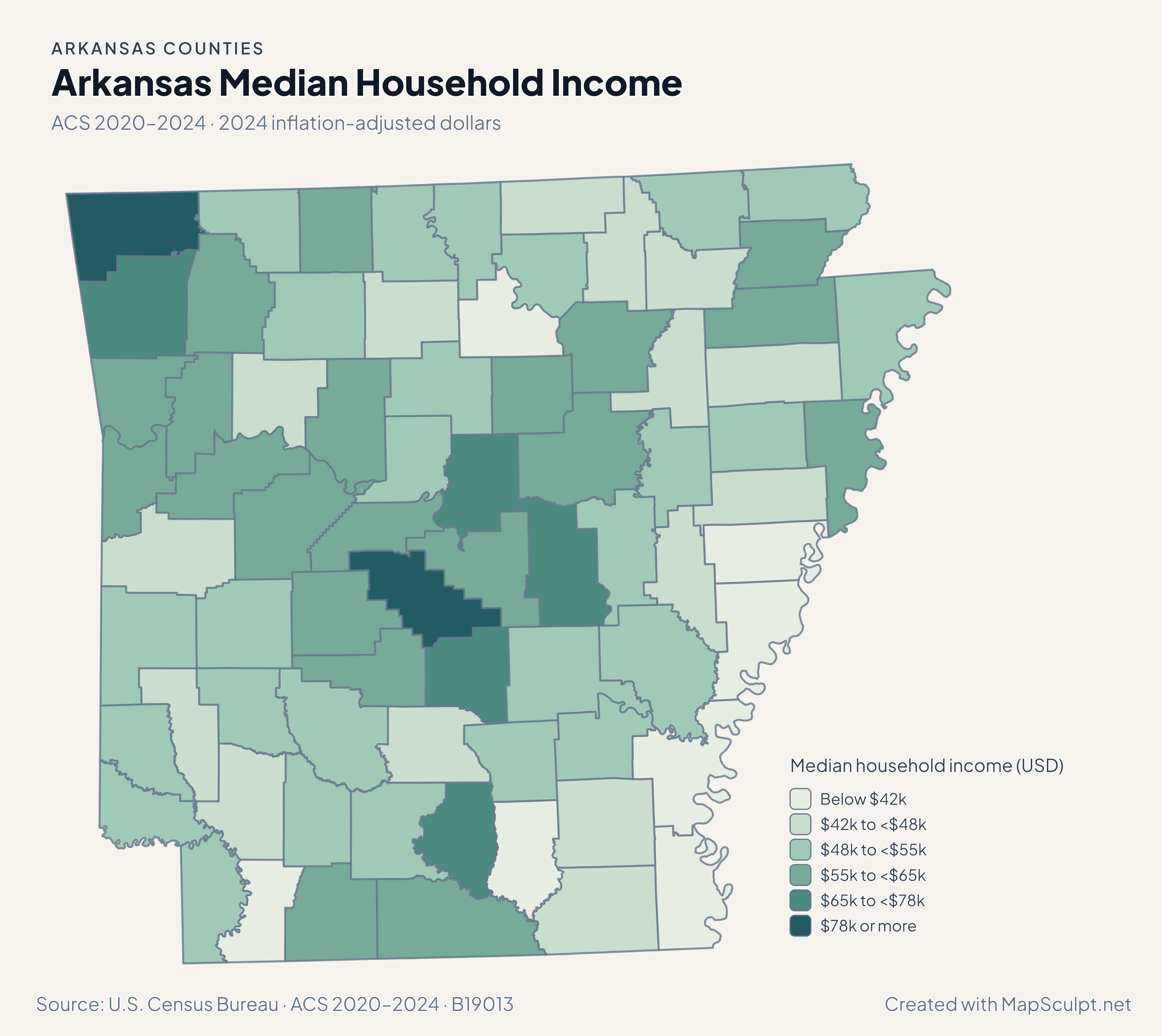
Compare Benton and Washington counties with central Arkansas and the Mississippi Delta. Use all 75 counties to map population change, compare ACS estimates, or join your own spreadsheet.

Free online editor · No sign-up required

75counties
individually editable

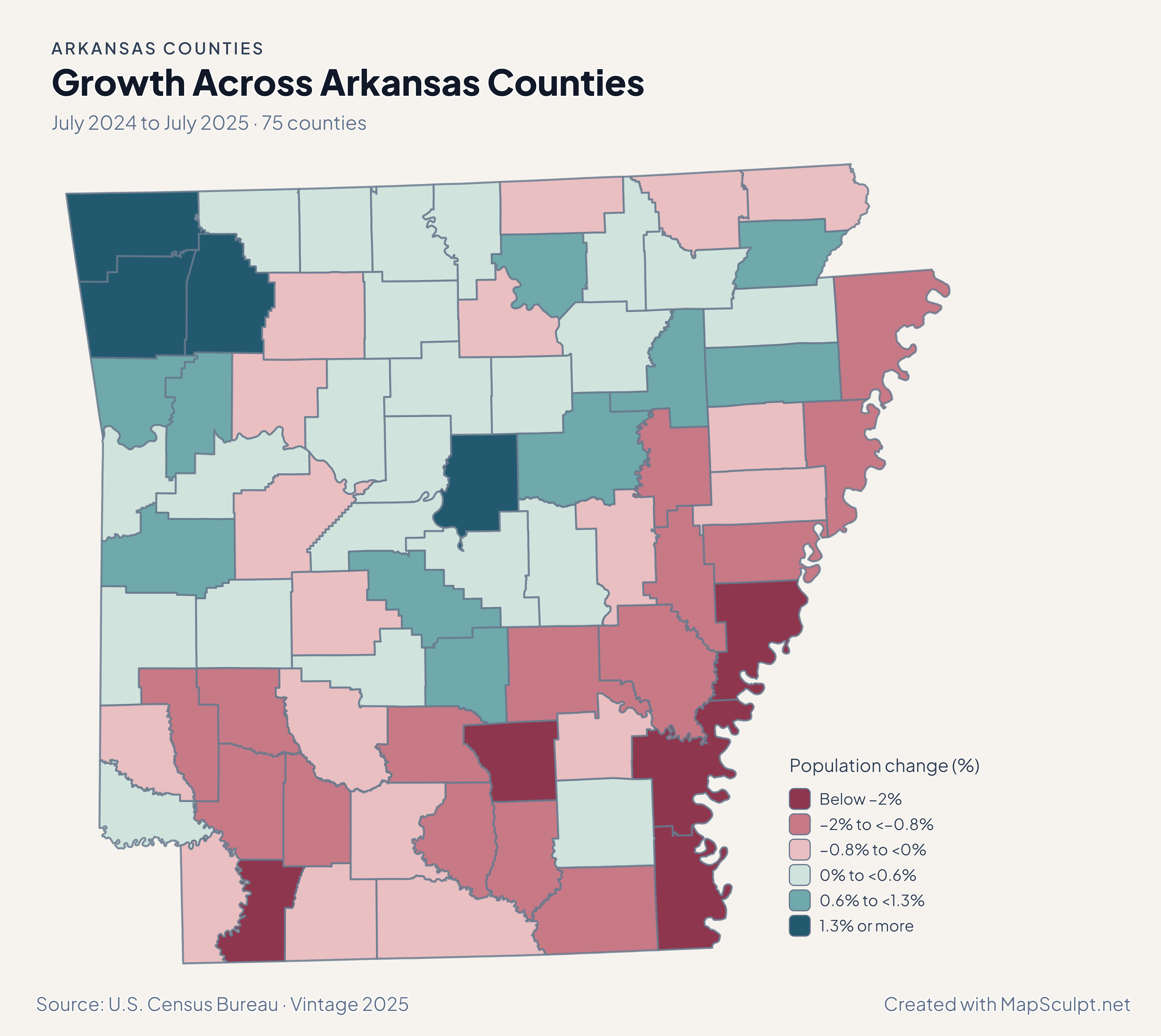
Growth Across Arkansas Counties

July 2024 to July 2025 · 75 counties

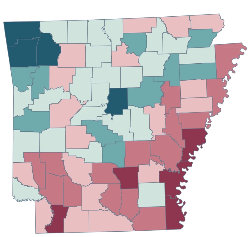
Arkansas population-change map highlighting gains in the northwest and losses in counties along the lower Mississippi.

Population change (%)

  • Below −2%
  • −2% to <−0.8%
  • −0.8% to <0%
  • 0% to <0.6%
  • 0.6% to <1.3%
  • 1.3% or more
U.S. Census Bureau · Vintage 2025Download complete PNG Percentage change from each area’s July 2024 population estimate.

KNOW YOUR GEOGRAPHY

From northwest Arkansas to the Delta

The map preserves Arkansas’s 75 Census counties, including irregular outlines along the Mississippi River. The Ozarks, Delta and Arkansas River Valley help orient the reader. The selectable shapes remain county boundaries.

Benton and Washington are separate northwest Arkansas counties. Little Rock is a municipality within Pulaski County, so the county outline is broader than the city.

Browse all county GEOIDs ↗

2025 Census boundaries

OFFICIAL DATA

Growth in northwest Arkansas and losses along parts of the Delta

The county population estimates show the direction of total change, then domestic migration isolates moves within the United States.

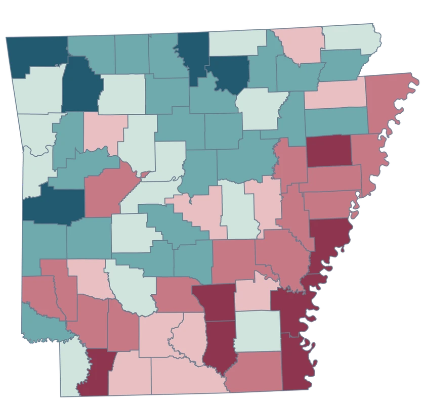
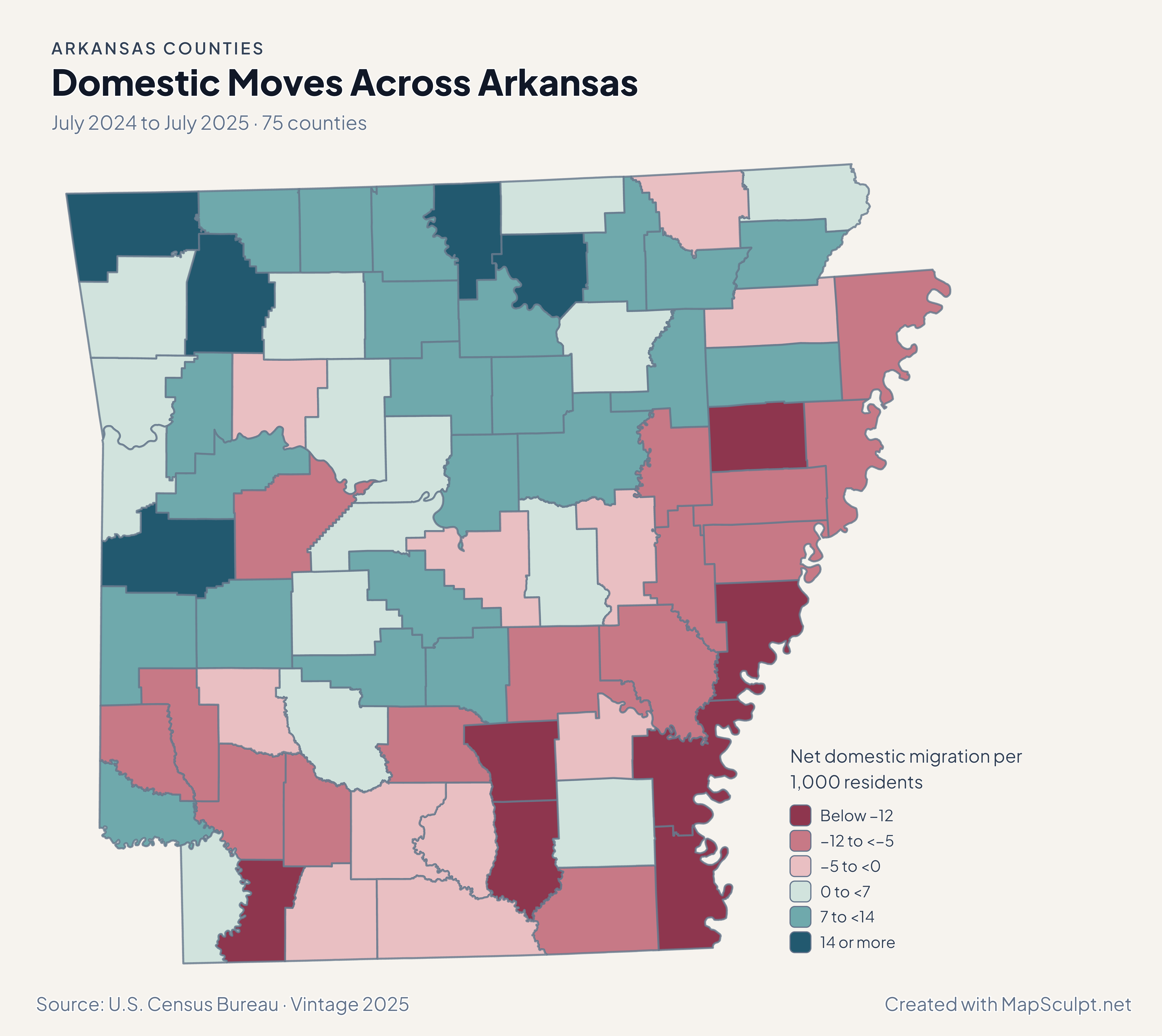
Arkansas net domestic migration map with a higher positive band in Benton and a strong loss band in Phillips.

July 2024 to July 2025 · 75 counties

Different domestic migration rates within northwest Arkansas

Benton recorded +22.41 net domestic movers per 1,000 residents, compared with +4.04 in Washington. In the Delta, Phillips recorded −19.78. These rates do not identify reasons for moving.

Net domestic migration per 1,000 residents

  • Below −12
  • −12 to <−5
  • −5 to <0
  • 0 to <7
  • 7 to <14
  • 14 or more

U.S. Census Bureau · Vintage 2025

Download complete PNG

Benton led Arkansas at 3.28%, Washington grew 1.44%, and Faulkner grew 1.37%. Desha County declined 3.11%. The map compares a single year of Census estimates. See the Census estimates ↗

MAKE IT YOURS

From county data to a finished map.

  1. Open the Arkansas editor

    Start with the full county-level geography.

  2. Match your rows by GEOID

    Keep GEOIDs such as 05007 in a text column so the leading zero stays in the CSV.

  3. Choose colors a reader can interpret

    Label each class and include a date and units for numerical data.

  4. Export the annotated map

    Preview the title, legend and source, then download the PNG.

TRY CSV IMPORT

Try joining six official GEOIDs.

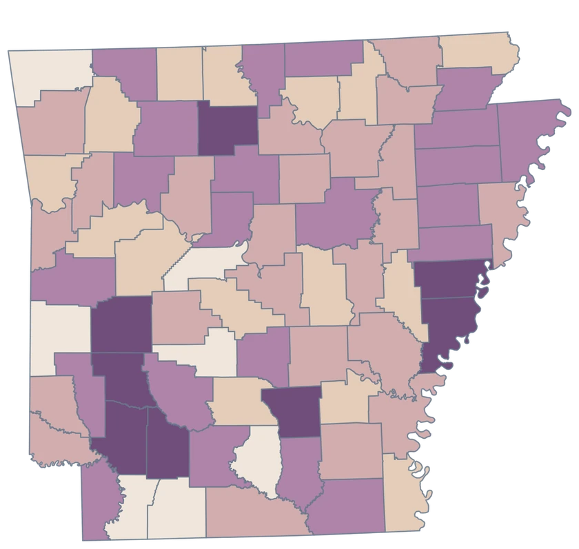
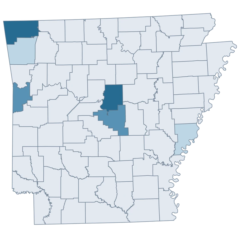
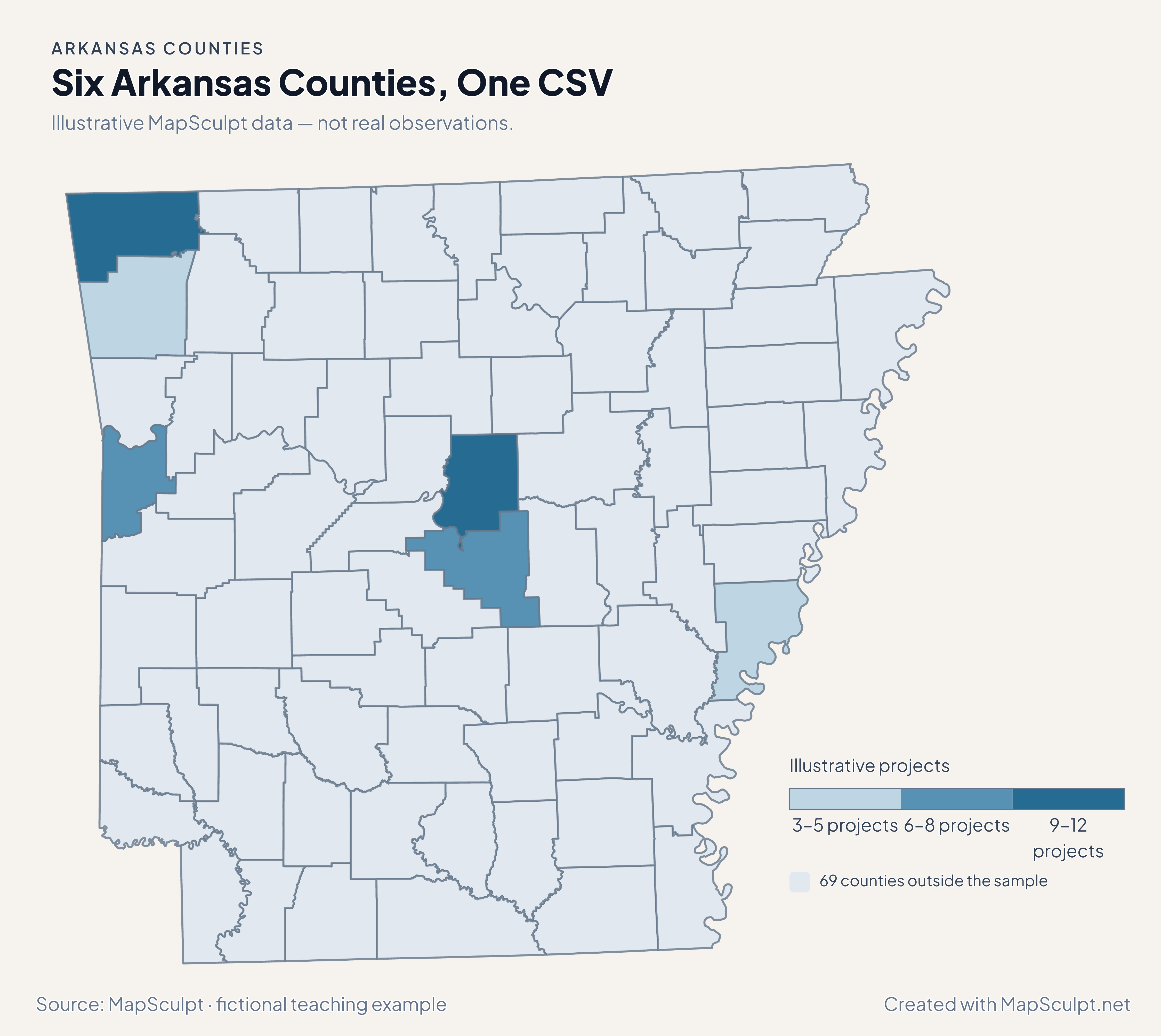
The fictional project values exercise three numeric bands. The remaining 69 counties keep the neutral fill.

Illustrative MapSculpt data — not real observations.
CountyGEOIDProjects
Benton County0500712
Washington County051435
Pulaski County051198
Faulkner County050459
Phillips County051073
Sebastian County051316

Keep GEOIDs such as 05007 in a text column so the leading zero stays in the CSV. Set custom boundaries of 3, 6, 9 and 12.

Download illustrative CSV ↓

Six Arkansas Counties, One CSV

Illustrative MapSculpt data — not real observations.

Illustrative Arkansas map highlighting six GEOIDs and leaving 69 areas neutral.

Illustrative projects

  • 3–5 projects
  • 6–8 projects
  • 9–12 projects
  • 69 counties outside the sample
Download complete PNG

CSV → Match 6 counties → Style → Export PNG Create an Arkansas map

COUNTY REFERENCE

Find all 75 Arkansas counties and GEOIDs.

Official county names and five-digit Census GEOIDs. Search by name or code.

  1. Arkansas CountyGEOID 05001
  2. Ashley CountyGEOID 05003
  3. Baxter CountyGEOID 05005
  4. Benton CountyGEOID 05007
  5. Boone CountyGEOID 05009
  6. Bradley CountyGEOID 05011
  7. Calhoun CountyGEOID 05013
  8. Carroll CountyGEOID 05015
  9. Chicot CountyGEOID 05017
  10. Clark CountyGEOID 05019
  11. Clay CountyGEOID 05021
  12. Cleburne CountyGEOID 05023
  13. Cleveland CountyGEOID 05025
  14. Columbia CountyGEOID 05027
  15. Conway CountyGEOID 05029
  16. Craighead CountyGEOID 05031
  17. Crawford CountyGEOID 05033
  18. Crittenden CountyGEOID 05035
  19. Cross CountyGEOID 05037
  20. Dallas CountyGEOID 05039
  21. Desha CountyGEOID 05041
  22. Drew CountyGEOID 05043
  23. Faulkner CountyGEOID 05045
  24. Franklin CountyGEOID 05047
  25. Fulton CountyGEOID 05049
  26. Garland CountyGEOID 05051
  27. Grant CountyGEOID 05053
  28. Greene CountyGEOID 05055
  29. Hempstead CountyGEOID 05057
  30. Hot Spring CountyGEOID 05059
  31. Howard CountyGEOID 05061
  32. Independence CountyGEOID 05063
  33. Izard CountyGEOID 05065
  34. Jackson CountyGEOID 05067
  35. Jefferson CountyGEOID 05069
  36. Johnson CountyGEOID 05071
  37. Lafayette CountyGEOID 05073
  38. Lawrence CountyGEOID 05075
  39. Lee CountyGEOID 05077
  40. Lincoln CountyGEOID 05079
  41. Little River CountyGEOID 05081
  42. Logan CountyGEOID 05083
  43. Lonoke CountyGEOID 05085
  44. Madison CountyGEOID 05087
  45. Marion CountyGEOID 05089
  46. Miller CountyGEOID 05091
  47. Mississippi CountyGEOID 05093
  48. Monroe CountyGEOID 05095
  49. Montgomery CountyGEOID 05097
  50. Nevada CountyGEOID 05099
  51. Newton CountyGEOID 05101
  52. Ouachita CountyGEOID 05103
  53. Perry CountyGEOID 05105
  54. Phillips CountyGEOID 05107
  55. Pike CountyGEOID 05109
  56. Poinsett CountyGEOID 05111
  57. Polk CountyGEOID 05113
  58. Pope CountyGEOID 05115
  59. Prairie CountyGEOID 05117
  60. Pulaski CountyGEOID 05119
  61. Randolph CountyGEOID 05121
  62. Saline CountyGEOID 05125
  63. Scott CountyGEOID 05127
  64. Searcy CountyGEOID 05129
  65. Sebastian CountyGEOID 05131
  66. Sevier CountyGEOID 05133
  67. Sharp CountyGEOID 05135
  68. St. Francis CountyGEOID 05123
  69. Stone CountyGEOID 05137
  70. Union CountyGEOID 05139
  71. Van Buren CountyGEOID 05141
  72. Washington CountyGEOID 05143
  73. White CountyGEOID 05145
  74. Woodruff CountyGEOID 05147
  75. Yell CountyGEOID 05149

U.S. Census Bureau · 2025 Cartographic Boundary Files

COMMON QUESTIONS

Arkansas county map questions.

What GEOID should I use for a Little Rock-area county comparison?

Use 05119 for Pulaski County. If your source measures Little Rock city alone, keep it separate from Pulaski County estimates.

Why does my spreadsheet show Arkansas codes with only four digits?

Spreadsheet software can drop the leading zero from the state prefix 05. Format the column as text and retain all five digits before exporting CSV.

Can I color Benton and Washington separately?

Yes. Use 05007 and 05143 respectively. They are independent rows, so different values can produce different fills.

Can I compare the Arkansas and Mississippi sides of the Delta?

Use the U.S. Counties map and join both states’ county GEOIDs. Add your own region definition if you want to group the Delta across the state line.

What does the population change in Desha County show?

It compares July 2024 and July 2025 Census estimates. A population loss alone does not establish how much was due to domestic moves.

Is Nevada County in this Arkansas editor?

Yes. Use 05099 for Nevada County, Arkansas. The state of Nevada has a separate county-equivalent editor.

YOUR NEXT MAP STARTS HERE

Make your own Arkansas county comparison.

Join county observations or custom categories, then export a map with a clear legend and source.

Create an Arkansas map