Skip to content
MapSculpt

GEOGRAPHIC MAP MAKER / MICHIGAN

Michigan
Counties Map Maker

See how county populations changed across both peninsulas, from southeast Michigan to the Lake Superior shore. Then compare domestic moves and use the same 83 boundaries for your own data.

Free online editor · No sign-up required

83counties
individually editable

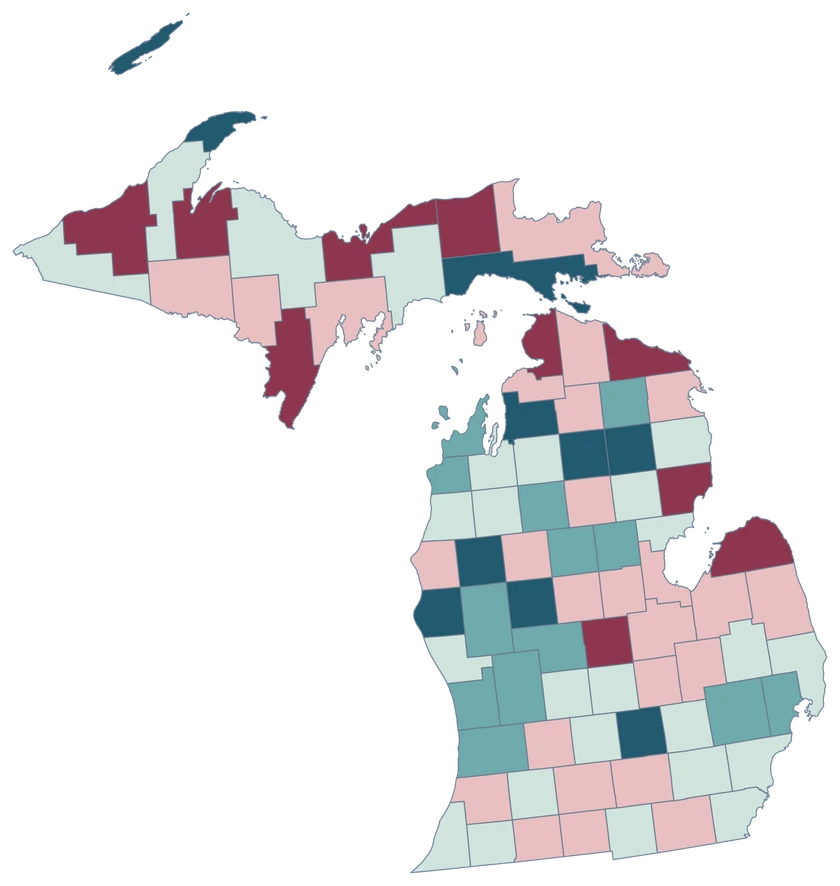
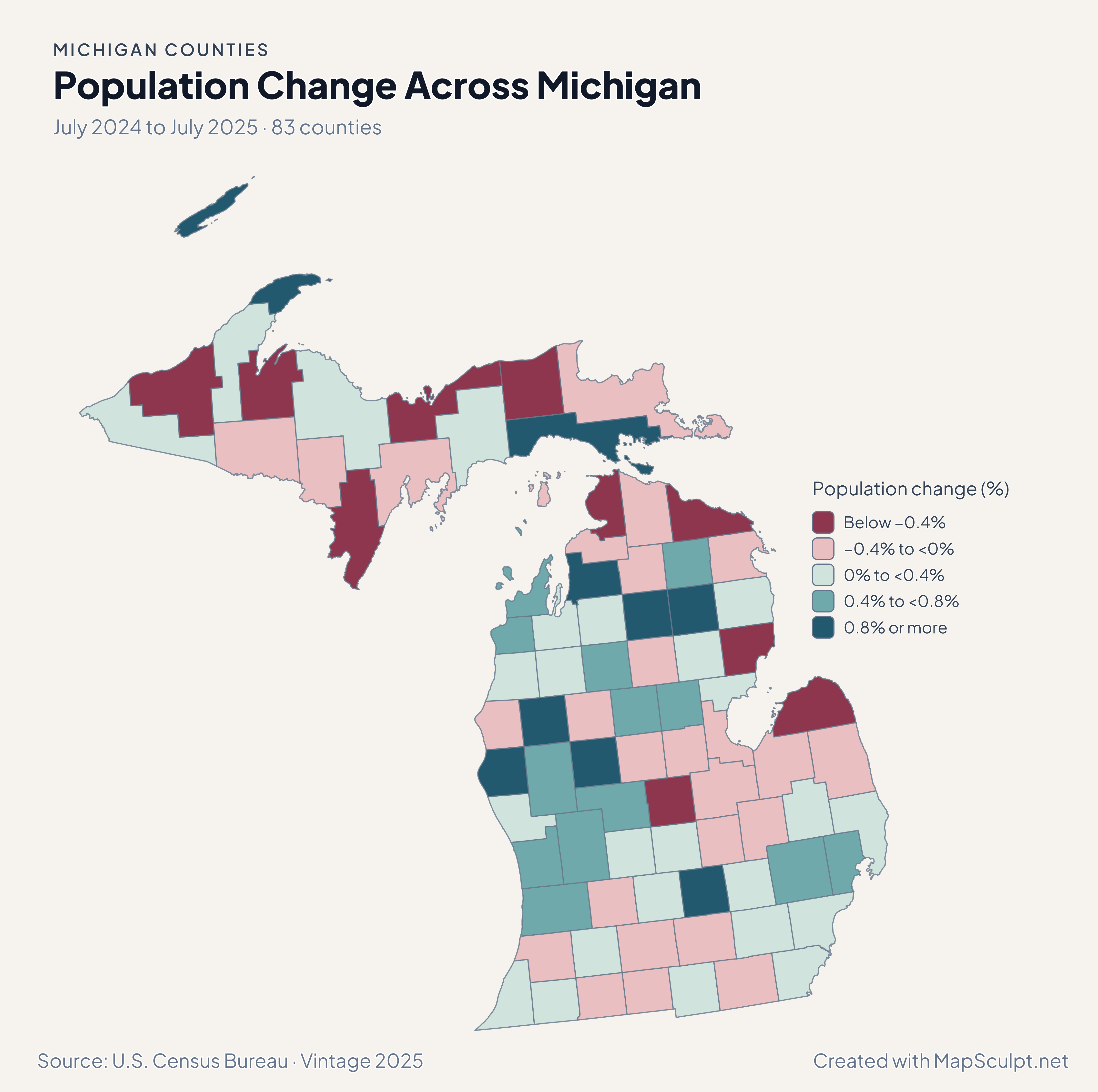
Population Change Across Michigan

July 2024 to July 2025 · 83 counties

Michigan population change across both peninsulas, with rose for declining counties and teal for gains.

Population change (%)

  • Below −0.4%
  • −0.4% to <0%
  • 0% to <0.4%
  • 0.4% to <0.8%
  • 0.8% or more
U.S. Census Bureau · Vintage 2025Download complete PNG Percentage change compares each area with its July 2024 population.

KNOW YOUR GEOGRAPHY

Both peninsulas, one county map.

Michigan’s county map includes the Upper and Lower Peninsulas. The Straits of Mackinac separate the large land areas, while the existing generalized Census geography retains islands as pieces of their respective counties.

The selectable units are counties. Detroit belongs to Wayne County, Grand Rapids belongs to Kent County, and the editor does not split either county into cities, townships or ZIP codes.

Browse all county GEOIDs ↗

2025 Census boundaries

OFFICIAL DATA

How Michigan’s county patterns change by measure.

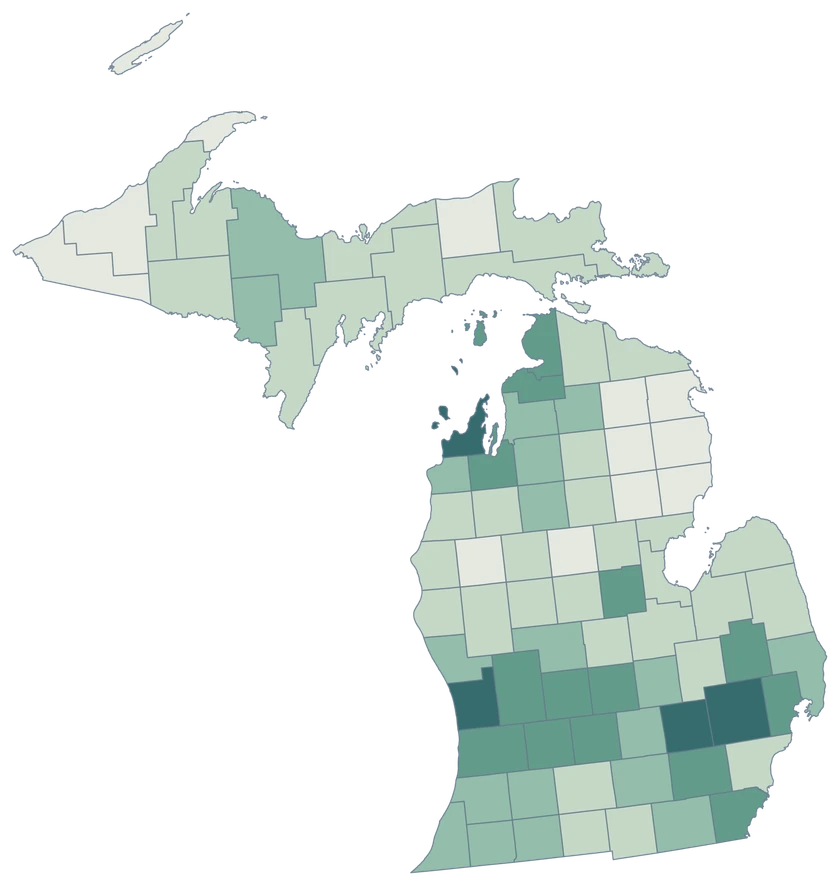
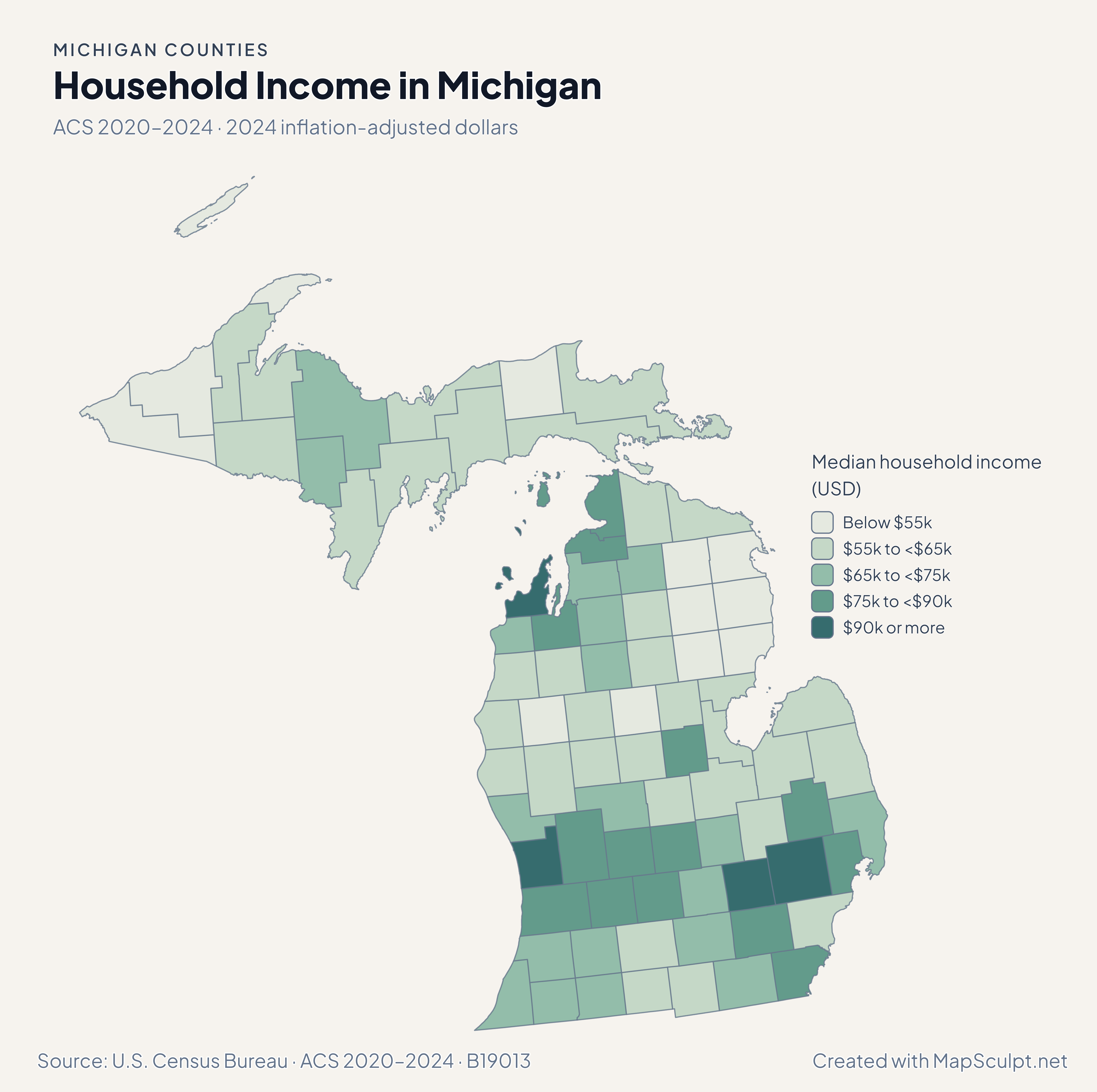
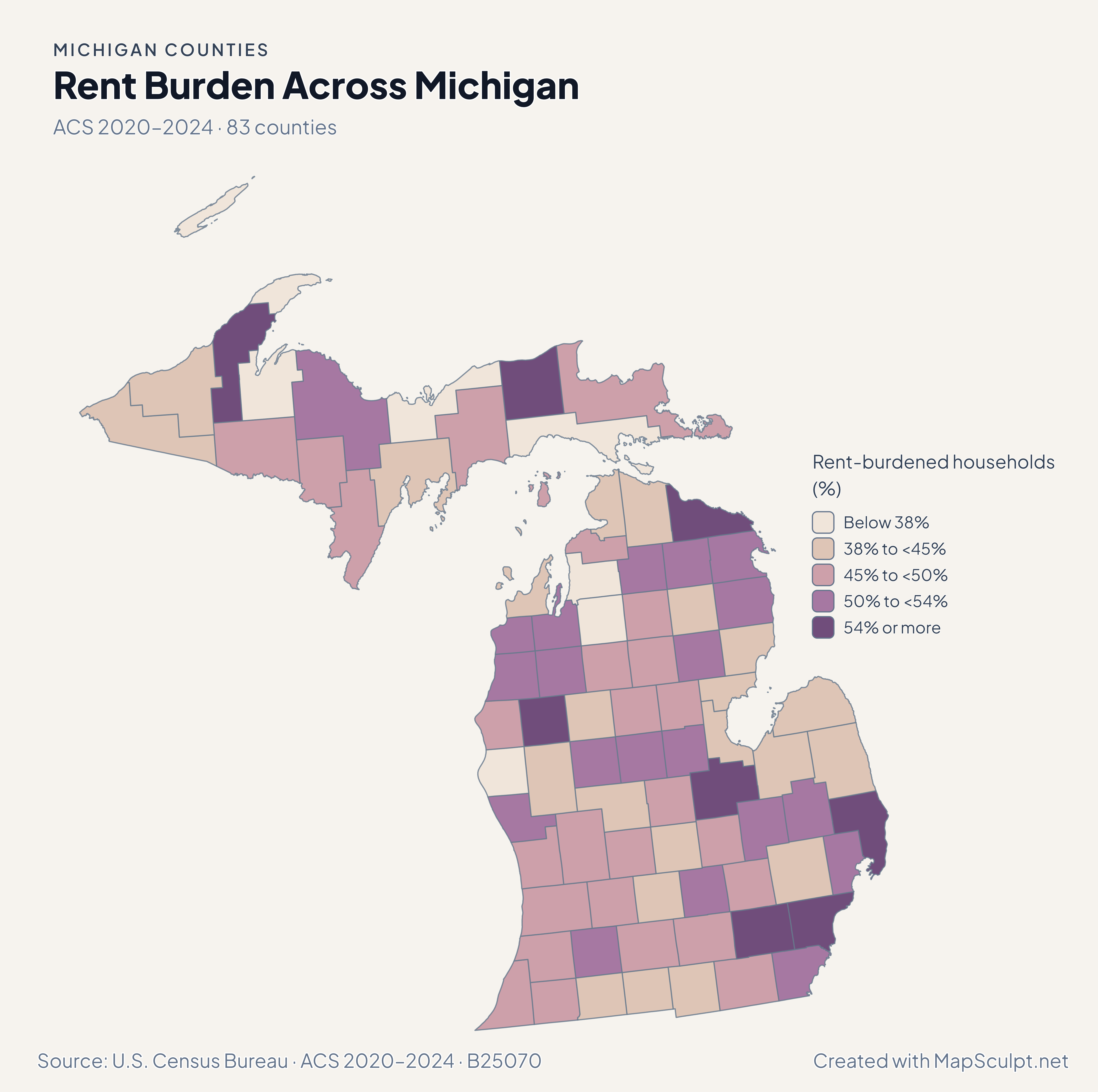
Compare July 2024–July 2025 population estimates with five-year ACS survey estimates for 2020–2024. Each map identifies its own period and units.

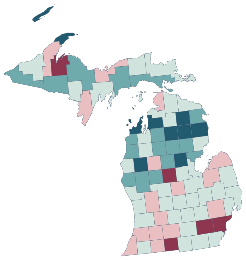
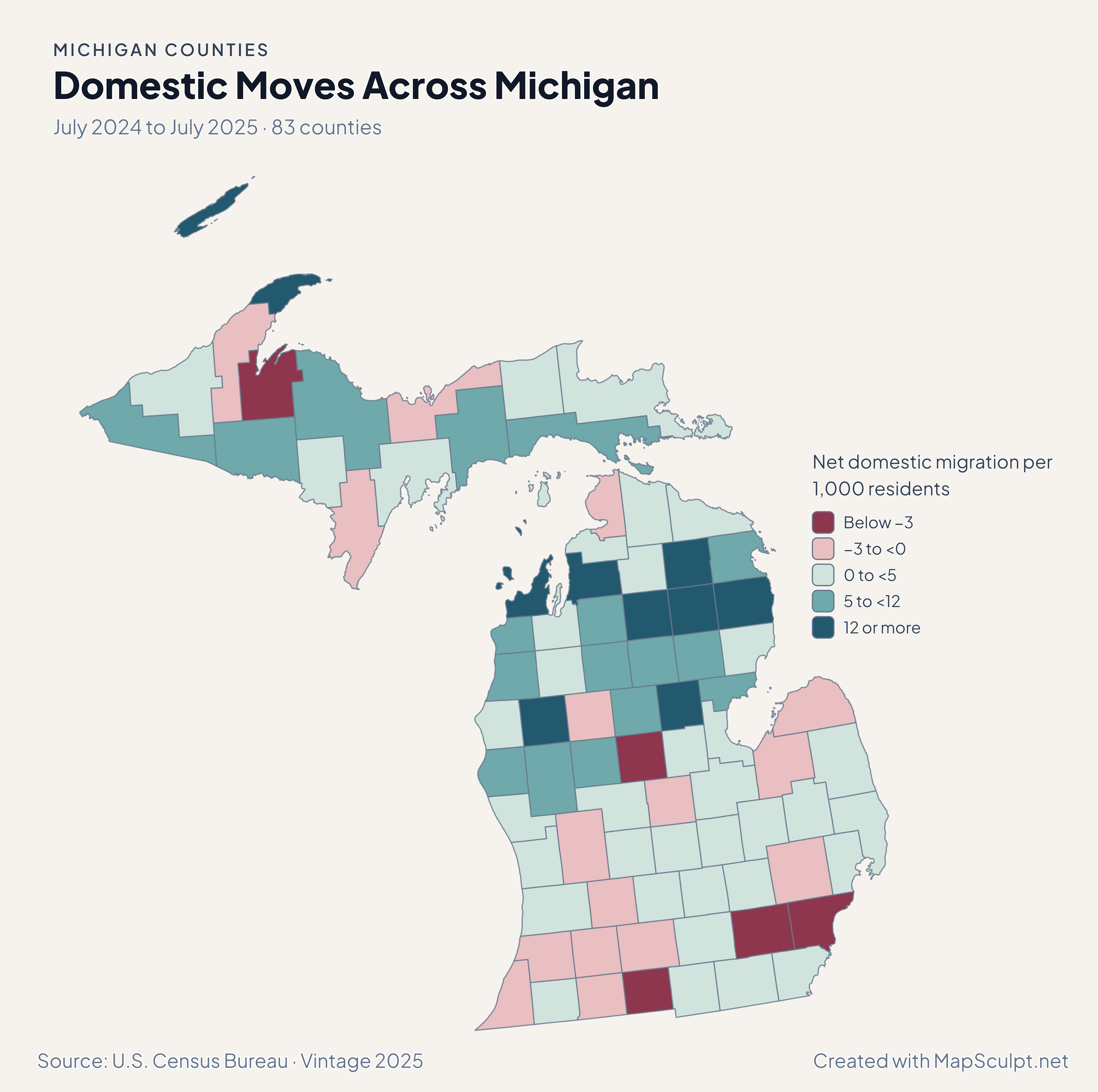
Michigan net domestic migration rates, showing Keweenaw in a high-gain class and Wayne in a loss class.

July 2024 to July 2025 · 83 counties

Domestic migration changes the picture.

Keweenaw recorded 12.87 net domestic movers per 1,000, and Wayne recorded −3.52. Keweenaw’s small population makes a rate useful for comparing relative change, but a high rate can represent a modest number of people.

Net domestic migration per 1,000 residents

  • Below −3
  • −3 to <0
  • 0 to <5
  • 5 to <12
  • 12 or more

U.S. Census Bureau · Vintage 2025

Download complete PNG

Forty-seven counties grew and 36 declined. Marquette gained 0.37%, while Ontonagon lost 0.73%. In the Lower Peninsula, Kent grew 0.72% and Wayne grew 0.20%. See the Census estimates ↗

MAKE IT YOURS

From county data to a finished map.

  1. Open the Michigan editor

    Start with all 83 selectable counties.

  2. Match your county records

    Use a five-digit GEOID such as 26163 for Wayne County. Review the match list before applying the data.

  3. Choose classes and colors

    Use bands that make the units and direction of change easy to read.

  4. Export with context

    Keep the source, period and legend visible in your full-resolution PNG.

TRY CSV IMPORT

Try six Michigan records.

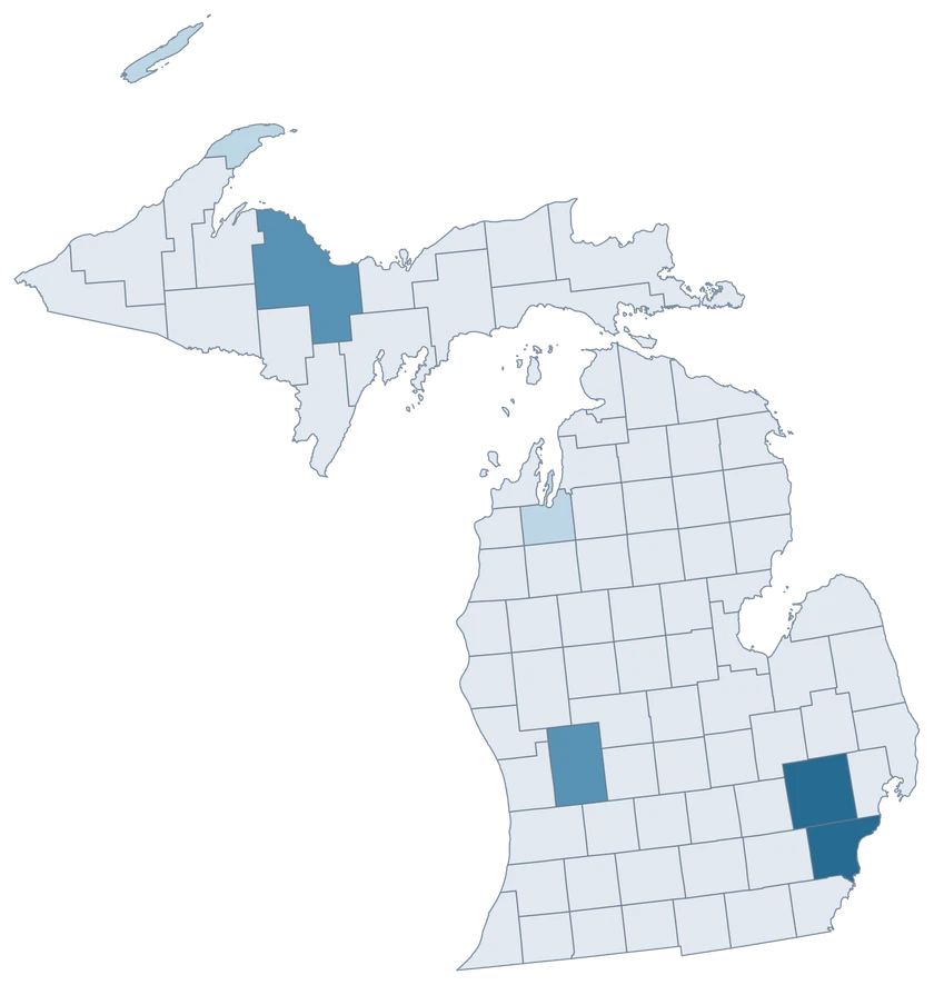
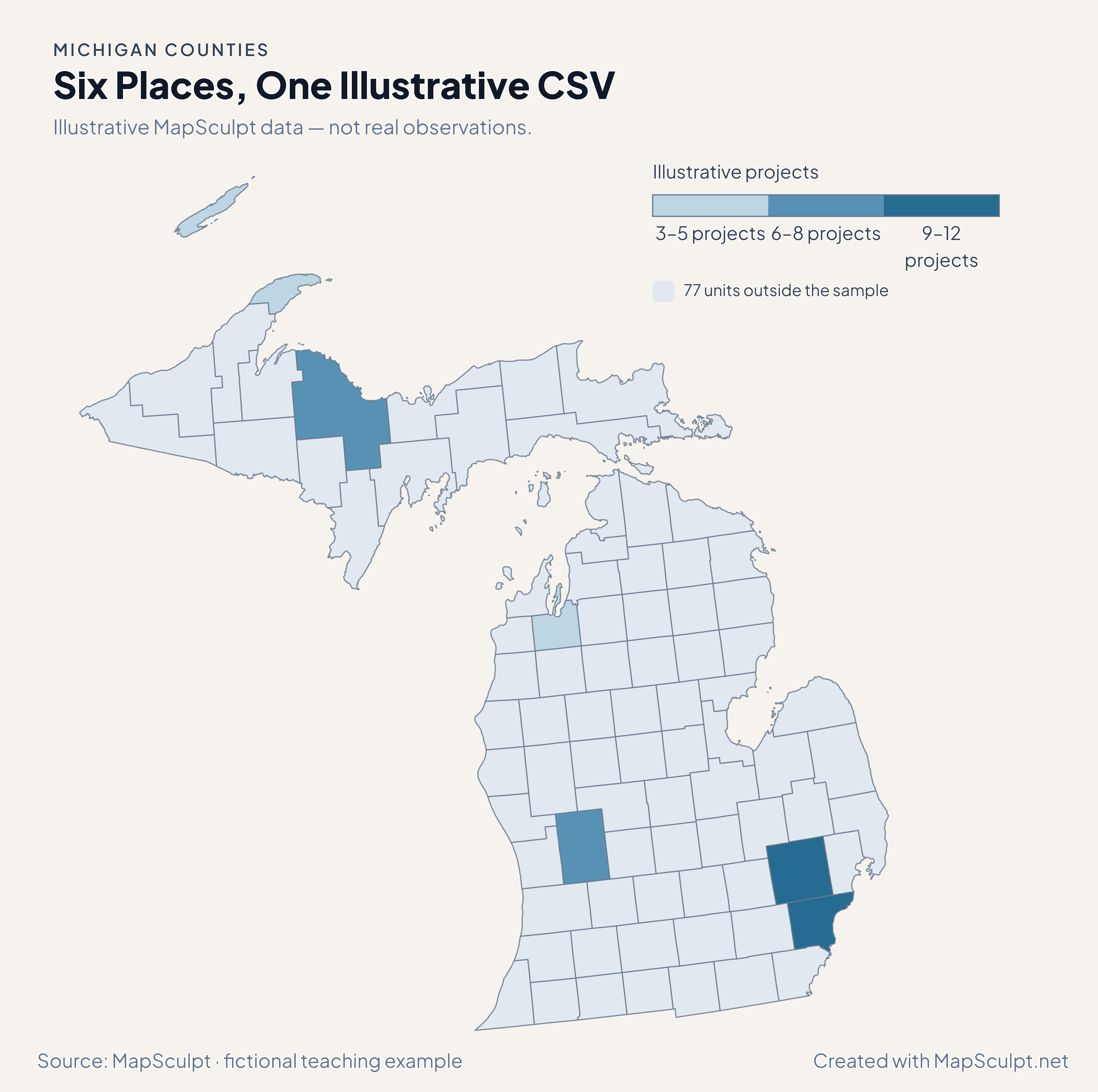
Import the fictional file, select IllustrativeProjects and use custom boundaries of 3, 6, 9 and 12. The remaining 77 units stay neutral.

Illustrative MapSculpt data — not real observations.
CountyGEOIDProjects
Wayne County2616312
Oakland County261259
Kent County260817
Grand Traverse County260553
Marquette County261038
Keweenaw County260835

Keep IDs as text. The sample uses 26163 for Wayne County and 26125 for Oakland County.

Download illustrative CSV ↓

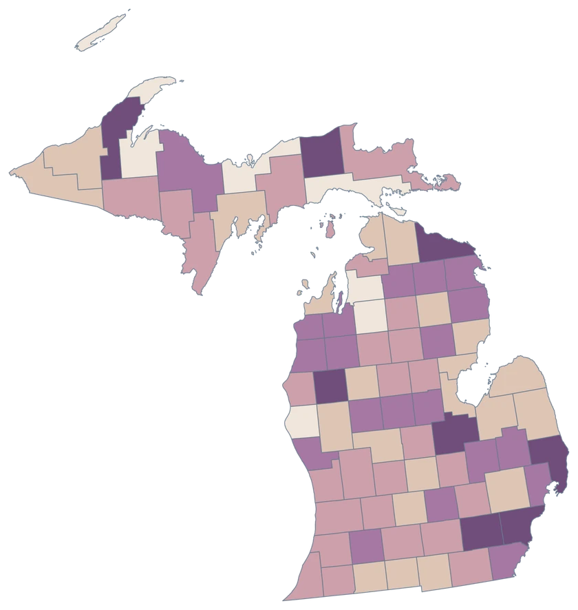
Six Places, One Illustrative CSV

Illustrative MapSculpt data — not real observations.

Michigan fictional project map with six sampled county-level units and 77 neutral units.

Illustrative projects

  • 3–5 projects
  • 6–8 projects
  • 9–12 projects
  • 77 units outside the sample
Download complete PNG

CSV → Match 6 counties → Style → Export PNG Create a Michigan map

COUNTY REFERENCE

All 83 Michigan counties and GEOIDs.

Official county names and five-digit Census GEOIDs. Search by name or code.

  1. Alcona CountyGEOID 26001
  2. Alger CountyGEOID 26003
  3. Allegan CountyGEOID 26005
  4. Alpena CountyGEOID 26007
  5. Antrim CountyGEOID 26009
  6. Arenac CountyGEOID 26011
  7. Baraga CountyGEOID 26013
  8. Barry CountyGEOID 26015
  9. Bay CountyGEOID 26017
  10. Benzie CountyGEOID 26019
  11. Berrien CountyGEOID 26021
  12. Branch CountyGEOID 26023
  13. Calhoun CountyGEOID 26025
  14. Cass CountyGEOID 26027
  15. Charlevoix CountyGEOID 26029
  16. Cheboygan CountyGEOID 26031
  17. Chippewa CountyGEOID 26033
  18. Clare CountyGEOID 26035
  19. Clinton CountyGEOID 26037
  20. Crawford CountyGEOID 26039
  21. Delta CountyGEOID 26041
  22. Dickinson CountyGEOID 26043
  23. Eaton CountyGEOID 26045
  24. Emmet CountyGEOID 26047
  25. Genesee CountyGEOID 26049
  26. Gladwin CountyGEOID 26051
  27. Gogebic CountyGEOID 26053
  28. Grand Traverse CountyGEOID 26055
  29. Gratiot CountyGEOID 26057
  30. Hillsdale CountyGEOID 26059
  31. Houghton CountyGEOID 26061
  32. Huron CountyGEOID 26063
  33. Ingham CountyGEOID 26065
  34. Ionia CountyGEOID 26067
  35. Iosco CountyGEOID 26069
  36. Iron CountyGEOID 26071
  37. Isabella CountyGEOID 26073
  38. Jackson CountyGEOID 26075
  39. Kalamazoo CountyGEOID 26077
  40. Kalkaska CountyGEOID 26079
  41. Kent CountyGEOID 26081
  42. Keweenaw CountyGEOID 26083
  43. Lake CountyGEOID 26085
  44. Lapeer CountyGEOID 26087
  45. Leelanau CountyGEOID 26089
  46. Lenawee CountyGEOID 26091
  47. Livingston CountyGEOID 26093
  48. Luce CountyGEOID 26095
  49. Mackinac CountyGEOID 26097
  50. Macomb CountyGEOID 26099
  51. Manistee CountyGEOID 26101
  52. Marquette CountyGEOID 26103
  53. Mason CountyGEOID 26105
  54. Mecosta CountyGEOID 26107
  55. Menominee CountyGEOID 26109
  56. Midland CountyGEOID 26111
  57. Missaukee CountyGEOID 26113
  58. Monroe CountyGEOID 26115
  59. Montcalm CountyGEOID 26117
  60. Montmorency CountyGEOID 26119
  61. Muskegon CountyGEOID 26121
  62. Newaygo CountyGEOID 26123
  63. Oakland CountyGEOID 26125
  64. Oceana CountyGEOID 26127
  65. Ogemaw CountyGEOID 26129
  66. Ontonagon CountyGEOID 26131
  67. Osceola CountyGEOID 26133
  68. Oscoda CountyGEOID 26135
  69. Otsego CountyGEOID 26137
  70. Ottawa CountyGEOID 26139
  71. Presque Isle CountyGEOID 26141
  72. Roscommon CountyGEOID 26143
  73. Saginaw CountyGEOID 26145
  74. Sanilac CountyGEOID 26151
  75. Schoolcraft CountyGEOID 26153
  76. Shiawassee CountyGEOID 26155
  77. St. Clair CountyGEOID 26147
  78. St. Joseph CountyGEOID 26149
  79. Tuscola CountyGEOID 26157
  80. Van Buren CountyGEOID 26159
  81. Washtenaw CountyGEOID 26161
  82. Wayne CountyGEOID 26163
  83. Wexford CountyGEOID 26165

U.S. Census Bureau · 2025 Cartographic Boundary Files

COMMON QUESTIONS

Michigan county map questions.

Can I select the Upper Peninsula as one feature?

Select or group its constituent counties in the editor. Their separate GEOIDs remain available for county-by-county data joins.

How are Michigan islands colored?

Island pieces retained in the generalized Census source share the identity and fill of their county. The map includes the retained Isle Royale geography within Keweenaw County.

Which GEOID should a Detroit-area record use?

Use 26163 if the observation covers Wayne County. A figure for the city of Detroit alone covers a smaller geography.

Can I compare Grand Rapids and northern Michigan?

For county-level measures, compare Kent County with northern counties using the same reference period and units.

Why is a small county prominent on the migration map?

The rates divide net moves by average population. Compare the underlying Census counts when the number of movers matters.

Does this map show townships?

The editor works with county boundaries. Township data needs aggregation to counties before joining it to this map.

YOUR NEXT MAP STARTS HERE

Put your Michigan data on the map.

Choose a comparison for Michigan, join your observations by Census GEOID and export a map with the period and source included.

Create a Michigan map