Skip to content
MapSculpt

GEOGRAPHIC MAP MAKER / MASSACHUSETTS

Massachusetts
Counties Map Maker

Compare domestic moves from Greater Boston to the Berkshires and the islands. Map all 14 Census counties, including places where county government has been abolished.

Free online editor · No sign-up required

14counties
individually editable

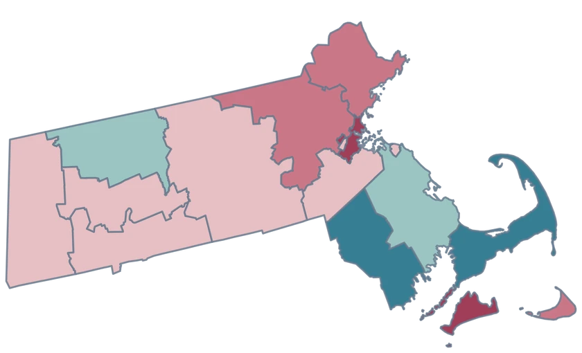
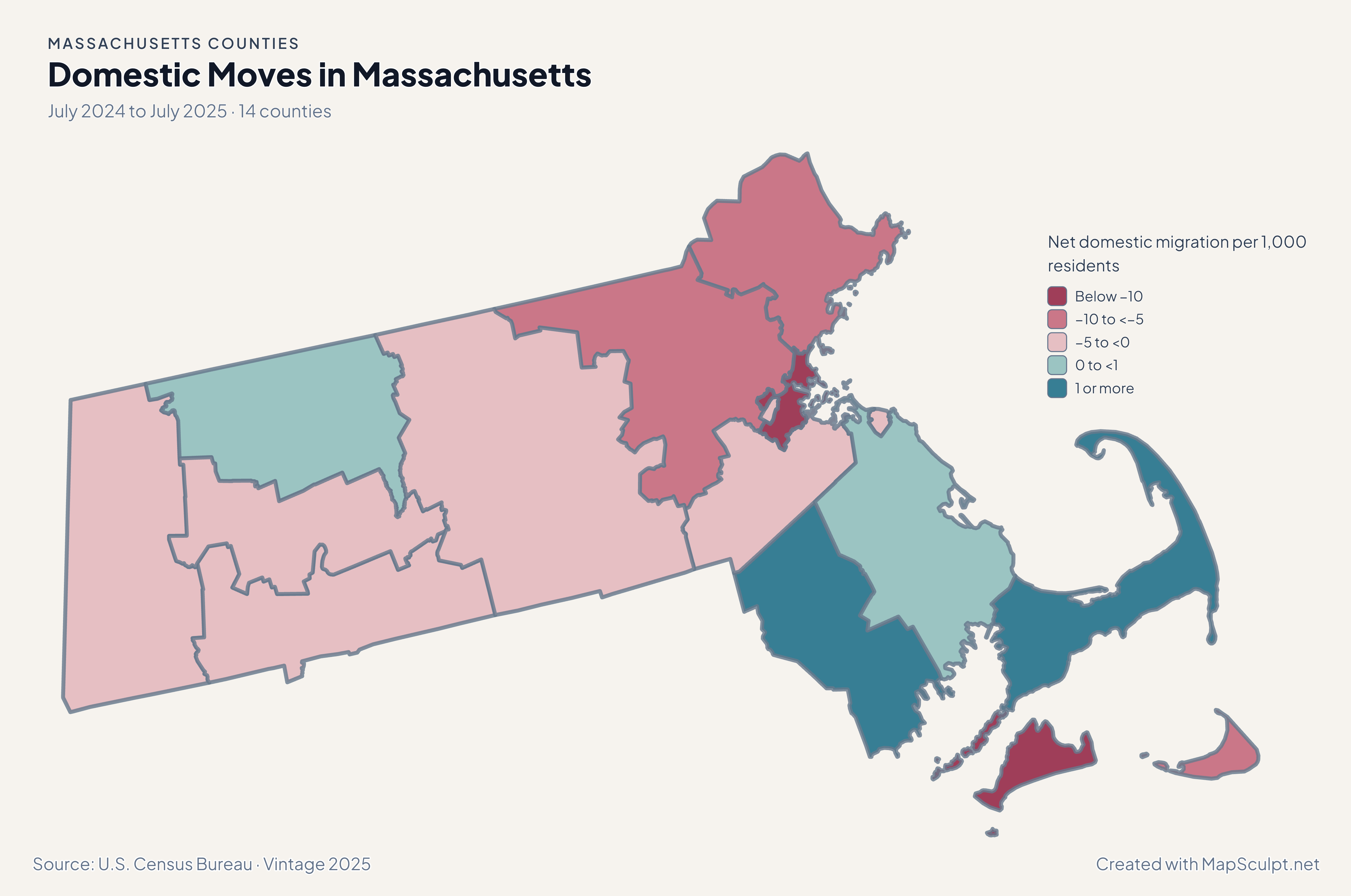
Domestic Moves in Massachusetts

July 2024 to July 2025 · 14 counties

Massachusetts domestic migration map with losses in Suffolk and Dukes and positive rates in Barnstable.

Net domestic migration per 1,000 residents

  • Below −10
  • −10 to <−5
  • −5 to <0
  • 0 to <1
  • 1 or more
U.S. Census Bureau · Vintage 2025Download complete PNG Net domestic moves within the United States, per 1,000 residents.

KNOW YOUR GEOGRAPHY

Fourteen Census counties, including Cape and island geography

The 14 county boundaries remain geographic units in Census data regardless of how county services are administered. County government has been abolished in several places, including Berkshire and Middlesex, but their Census identifiers remain in the map.

Barnstable covers Cape Cod, while Dukes and Nantucket each have separate Census GEOIDs. Island pieces retained by the cartographic source share the fill of their respective county.

Browse all county GEOIDs ↗

2025 Census boundaries

OFFICIAL DATA

Boston and Cape Cod moved in different directions.

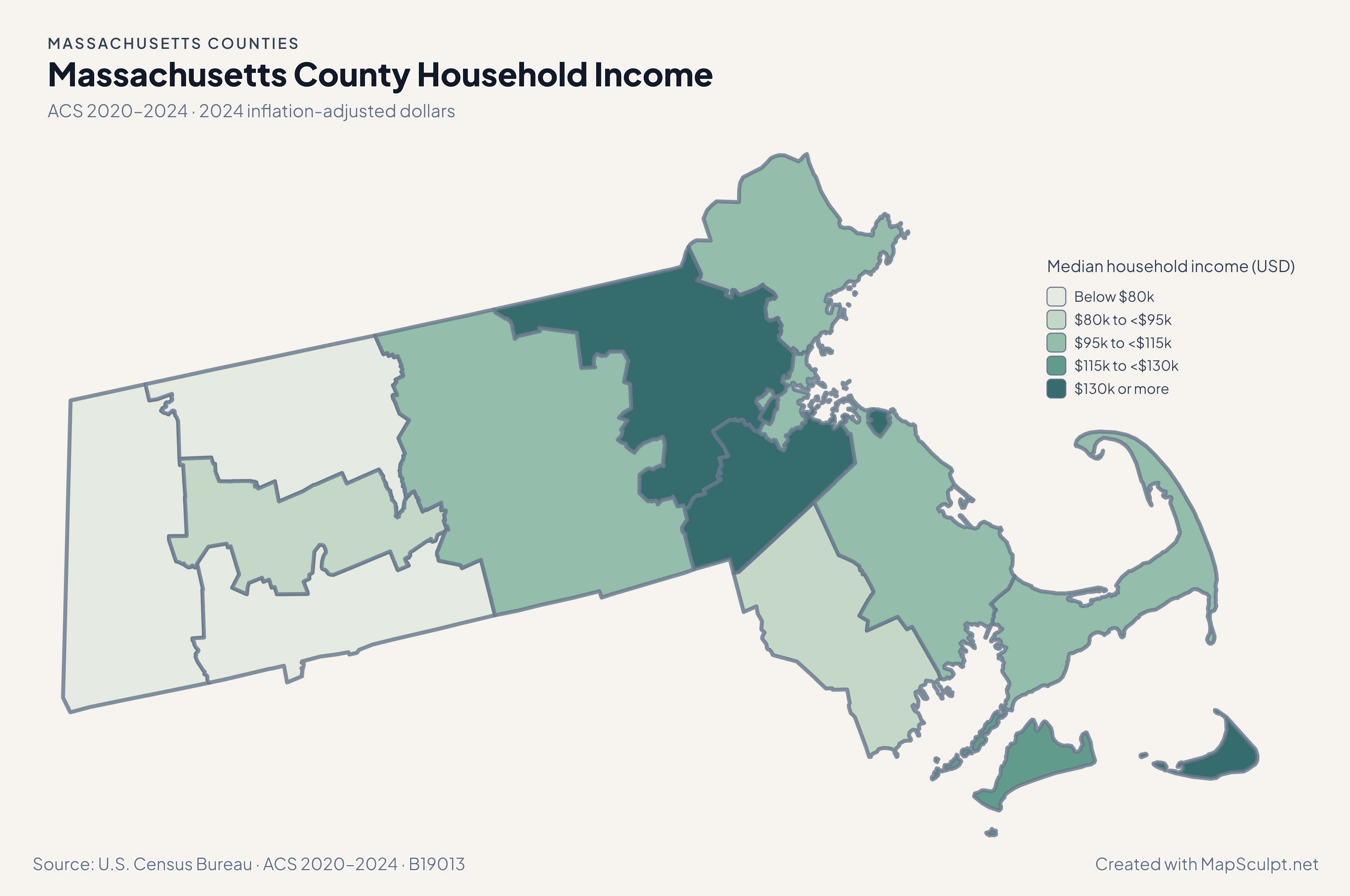
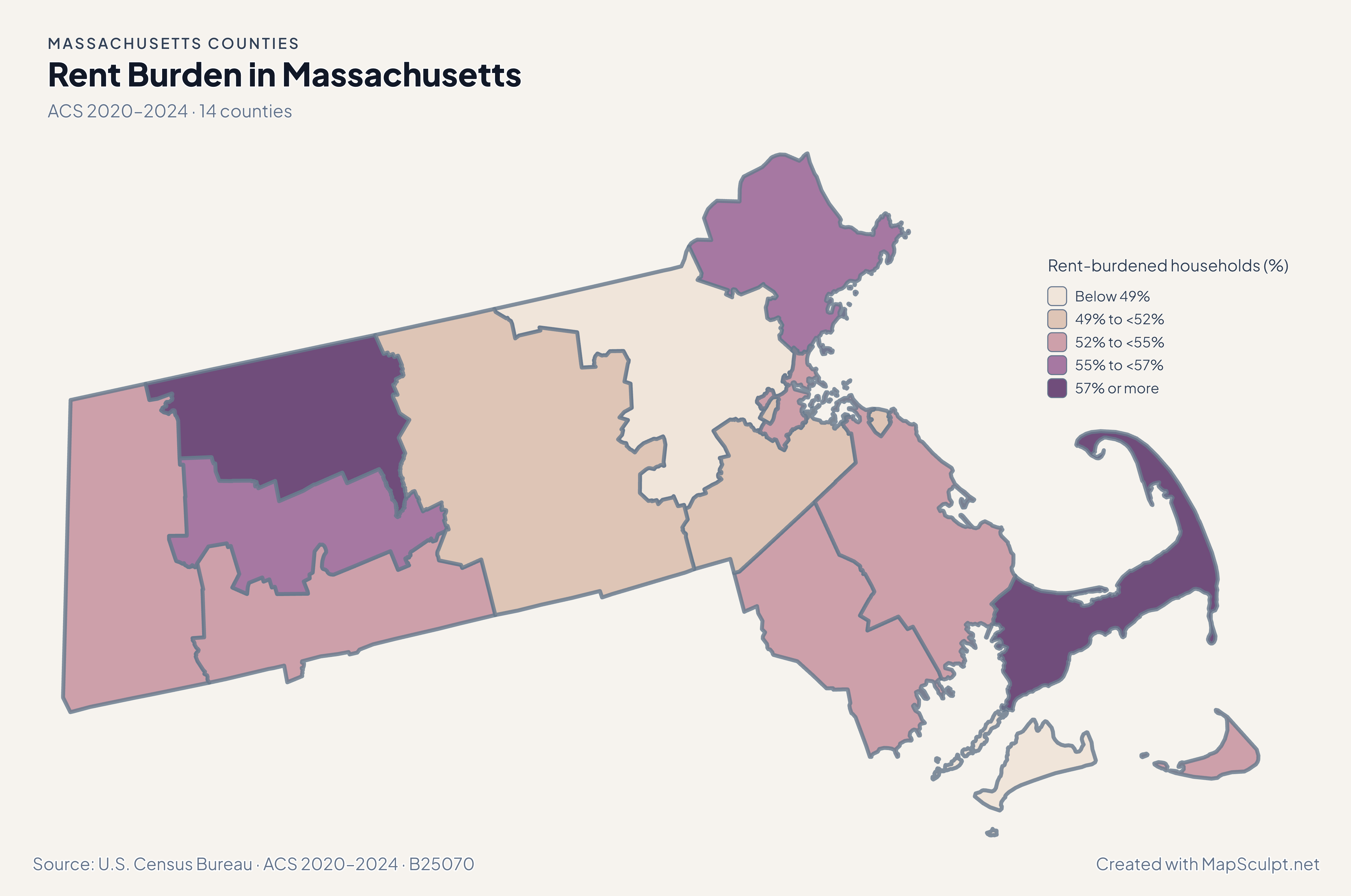
Compare Cape, island and inland counties across the 2024–2025 estimates and the five-year ACS.

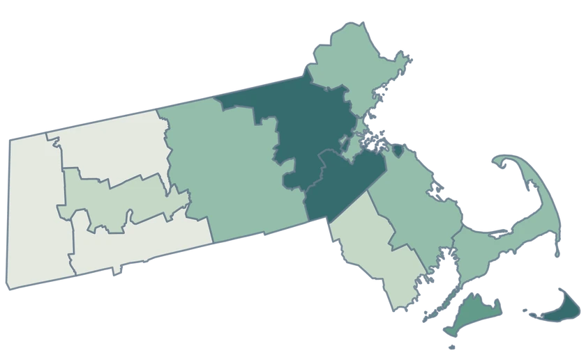
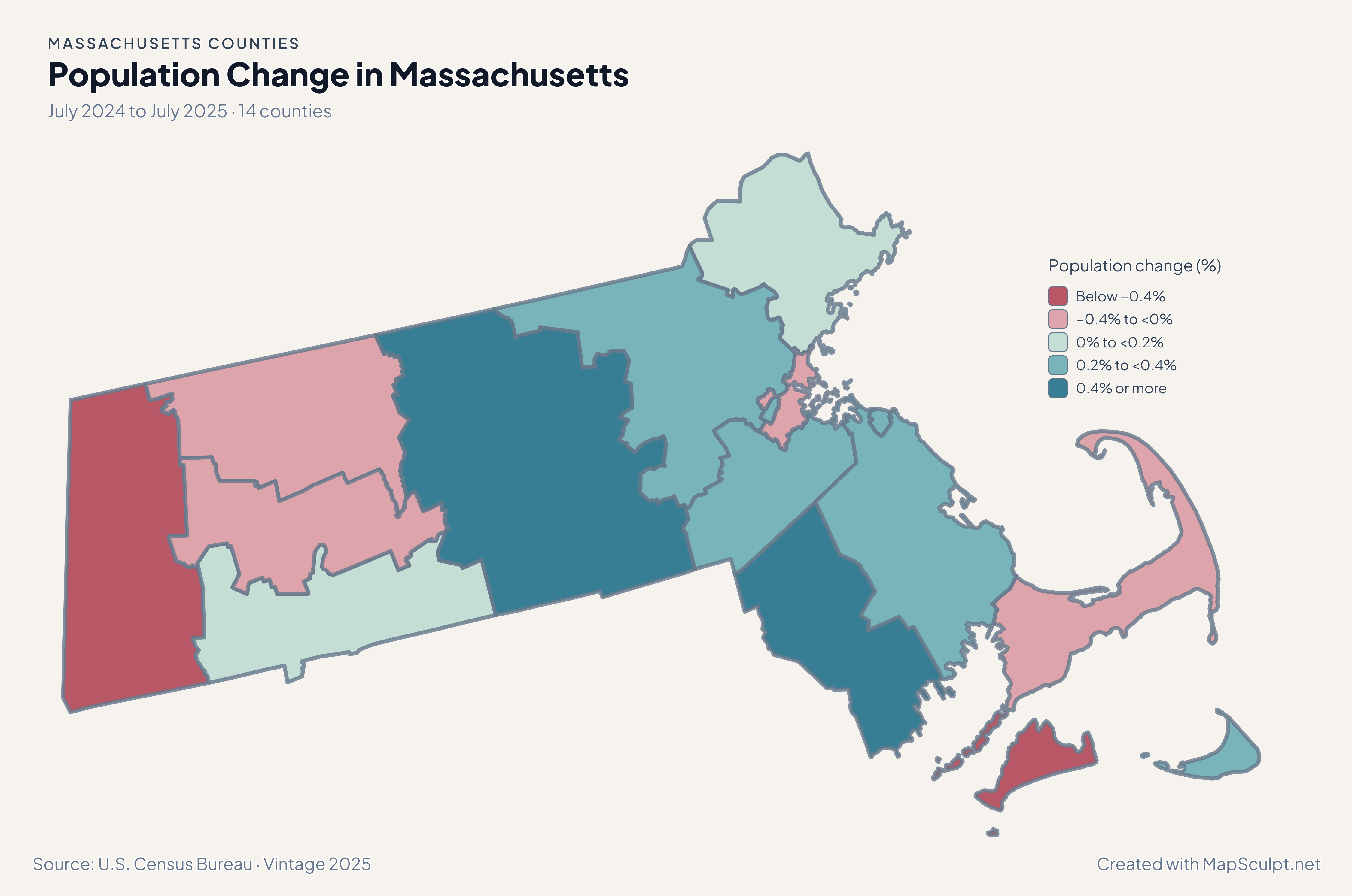
Massachusetts population change from Berkshire through Worcester to the Cape and islands.

July 2024 to July 2025 · 14 counties

The state had counties on both sides of zero

Eight counties grew and six declined. Worcester led at 0.54%; Berkshire declined 0.64%. Middlesex grew 0.36% despite net domestic out-migration.

Population change (%)

  • Below −0.4%
  • −0.4% to <0%
  • 0% to <0.2%
  • 0.2% to <0.4%
  • 0.4% or more

U.S. Census Bureau · Vintage 2025

Download complete PNG

Suffolk recorded −16.36 net domestic movers per 1,000 residents, while Barnstable recorded 2.34. Dukes recorded −11.32. The map compares rates within a single period and uses the same average-population denominator convention in every county. See the Census estimates ↗

MAKE IT YOURS

From county data to a finished map.

  1. Open the Massachusetts editor

    Start with all 14 counties.

  2. Match your data by GEOID

    Keep GEOIDs as text. The example uses Suffolk County, 25025, and five other official county-level records.

  3. Explain what the colors measure

    Set class breaks, add the reference period, and include a legend and source.

  4. Download the complete map

    Check small features and labels, then export the finished high-resolution PNG.

TRY CSV IMPORT

Practice joining six official GEOIDs.

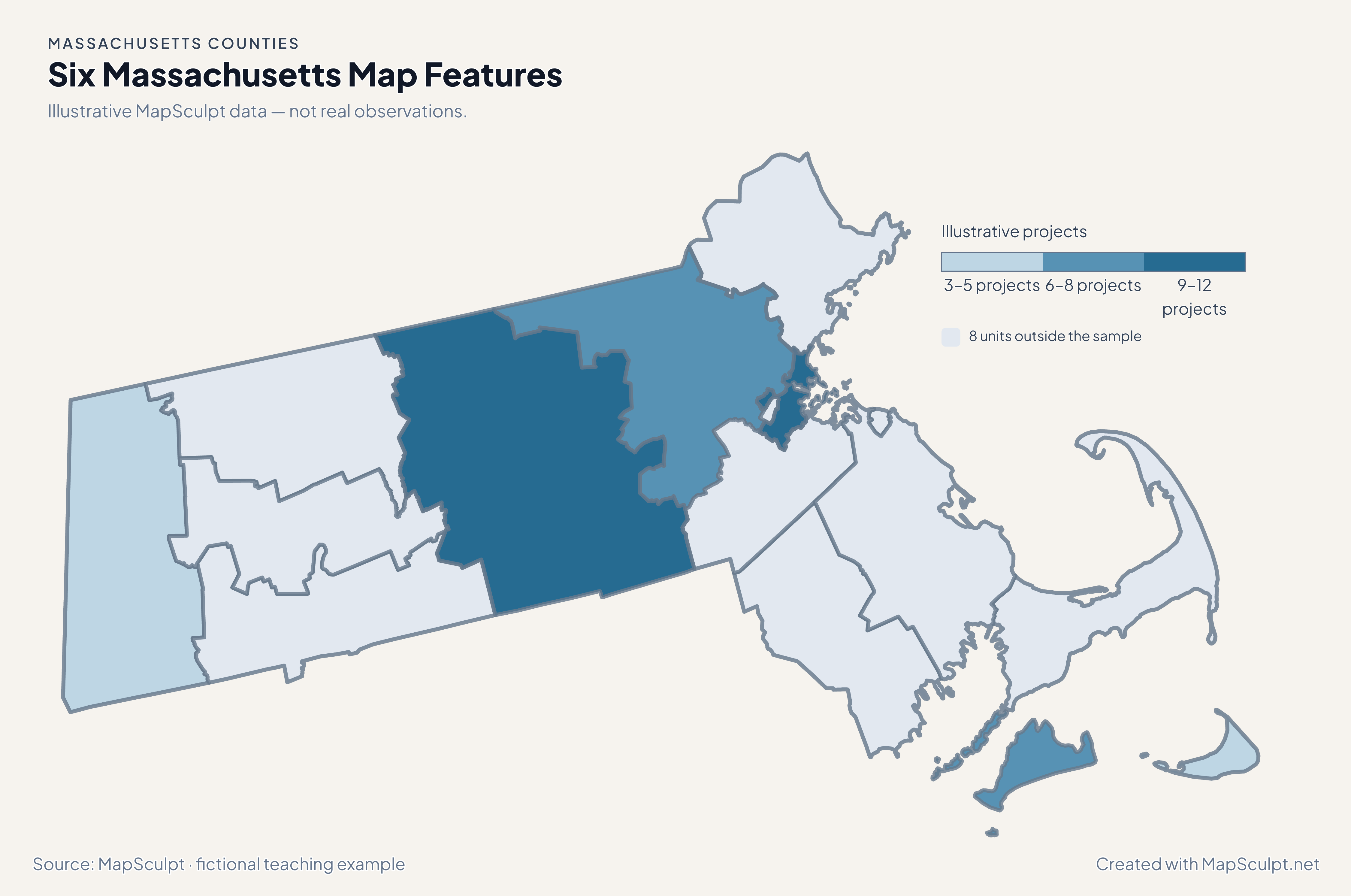
Import the fictional project counts and choose numeric boundaries of 3, 6, 9 and 12. The other 8 counties use a neutral fill.

Illustrative MapSculpt data — not real observations.
CountyGEOIDProjects
Suffolk County2502512
Middlesex County250176
Worcester County250279
Berkshire County250033
Dukes County250077
Nantucket County250195

Keep GEOIDs as text. The example uses Suffolk County, 25025, and five other official county-level records.

Download illustrative CSV ↓

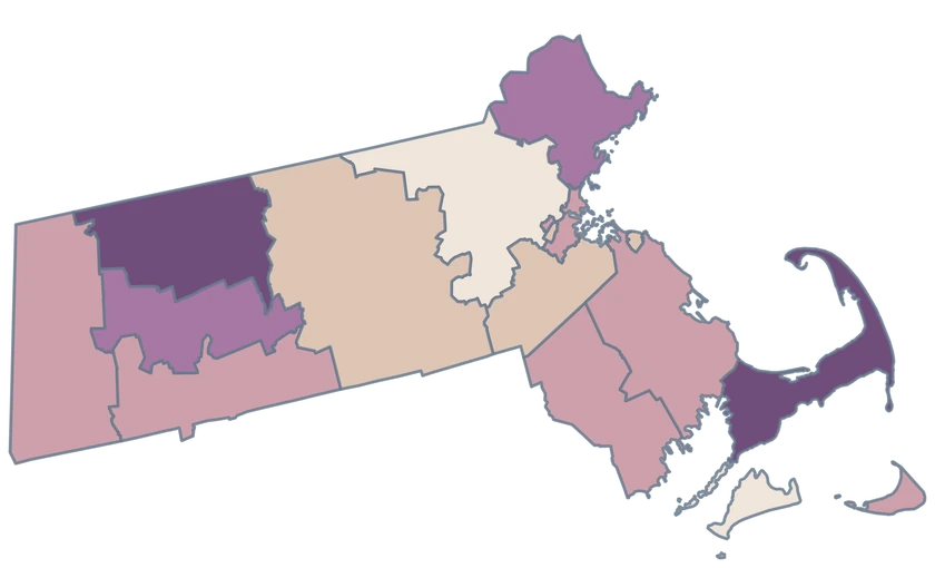
Six Massachusetts Map Features

Illustrative MapSculpt data — not real observations.

Illustrative Massachusetts project map identifying six features and leaving 8 neutral.

Illustrative projects

  • 3–5 projects
  • 6–8 projects
  • 9–12 projects
  • 8 units outside the sample
Download complete PNG

CSV → Match 6 counties → Style → Export PNG Create a Massachusetts map

GEOGRAPHY NOTES

Census geography outlasts county government

Massachusetts still has 14 county areas for geographic analysis. County-government abolition changed who administers services in some places, including Berkshire and Middlesex. County datasets still use the same geographic identifiers.

Commonwealth of Massachusetts · County government history

COUNTY REFERENCE

Find all 14 Massachusetts counties and GEOIDs.

Official county names and five-digit Census GEOIDs. Search by name or code.

  1. Barnstable CountyGEOID 25001
  2. Berkshire CountyGEOID 25003
  3. Bristol CountyGEOID 25005
  4. Dukes CountyGEOID 25007
  5. Essex CountyGEOID 25009
  6. Franklin CountyGEOID 25011
  7. Hampden CountyGEOID 25013
  8. Hampshire CountyGEOID 25015
  9. Middlesex CountyGEOID 25017
  10. Nantucket CountyGEOID 25019
  11. Norfolk CountyGEOID 25021
  12. Plymouth CountyGEOID 25023
  13. Suffolk CountyGEOID 25025
  14. Worcester CountyGEOID 25027

U.S. Census Bureau · 2025 Cartographic Boundary Files

COMMON QUESTIONS

Massachusetts county map questions.

Are abolished counties still included?

Yes. The 14 Census counties remain usable geographic units, even where county government or functions have changed.

What is the county GEOID for Boston-area county data?

Use 25025 if the observation covers Suffolk County. Boston city data has a different geographic scope.

Which counties contain Martha’s Vineyard and Nantucket?

Martha’s Vineyard is within Dukes County, GEOID 25007. Nantucket County is a separate unit, GEOID 25019.

How is Cape Cod represented?

Use Barnstable County, GEOID 25001, for county-level Cape Cod observations. The geometry uses the generalized Census shoreline.

Can I color Massachusetts towns?

This map selects counties. Use town boundaries for town-level observations or aggregate the observations before joining them to counties.

Why can Middlesex grow with net domestic losses?

Total population change includes international migration, births, deaths and adjustments in addition to moves within the United States.

YOUR NEXT MAP STARTS HERE

Build a map of the Massachusetts counties you need.

Join your data by GEOID or select features by hand, then export a PNG with a useful title and source.

Create a Massachusetts map