MapSculpt

EUROPE / CUSTOM COUNTRY MAPS

Create and Color Your Own Map of Europe

Customize European countries, visualize statistics, add a legend and download a polished PNG map for presentations, reports or data visualizations.

Create My Europe Map

Free online tool · No design experience required

MAP EXAMPLE / EUROPE

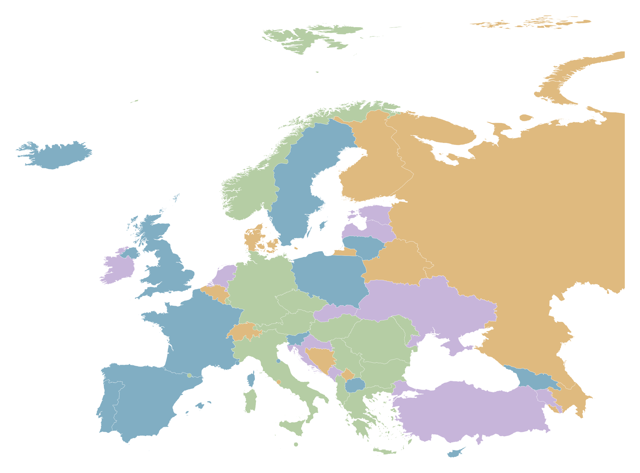
Illustrative map of all 50 selectable European identities, including Russia, Türkiye, Georgia, the United Kingdom and microstates.
50 selectable map identities · Custom colors and legends · Illustrative colors

EUROPEAN GEOPOLITICS / 2026

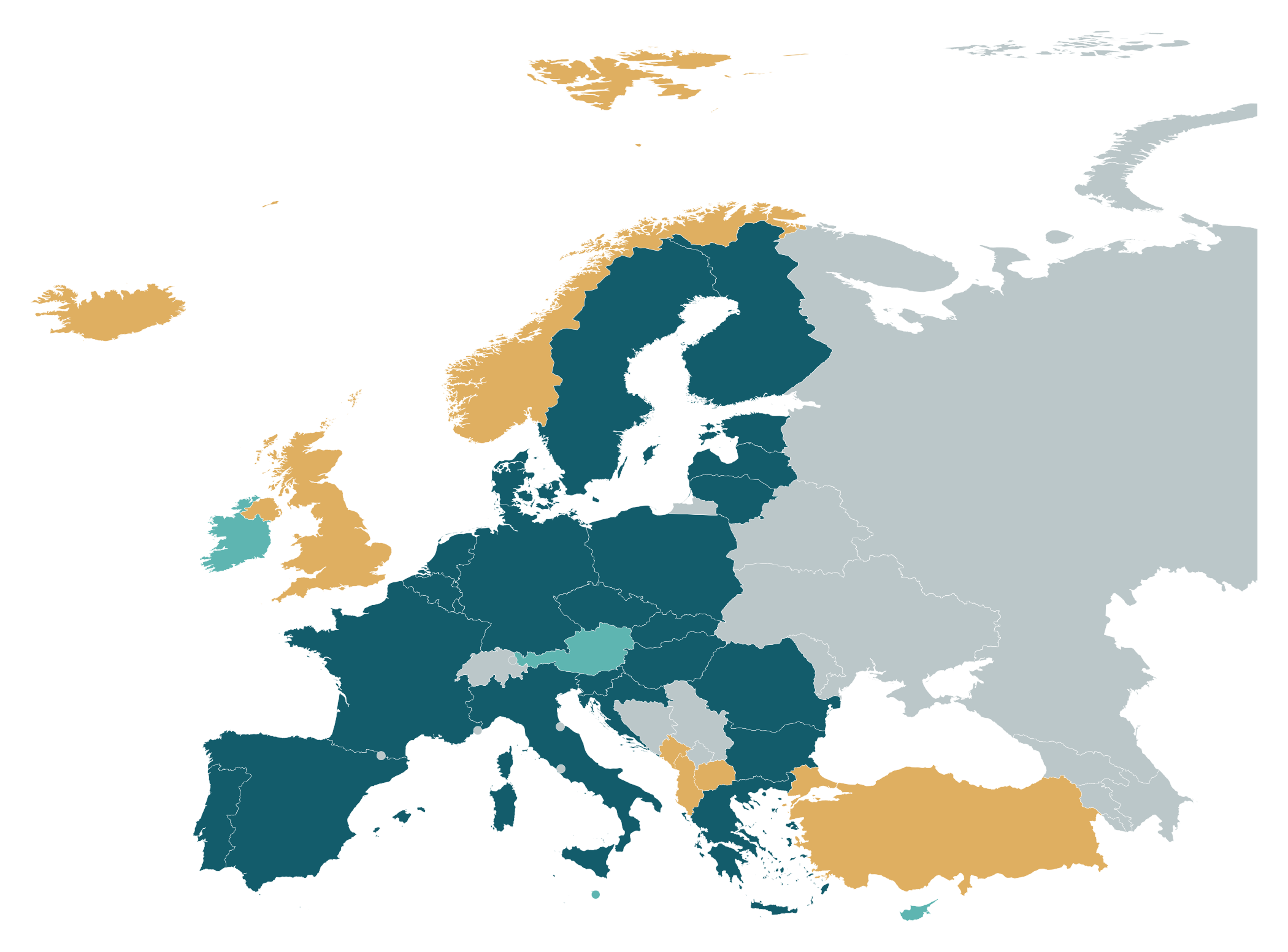
Of the 50 mapped identities: 23 both EU and NATO; 4 EU-only; 7 NATO-only; 16 neither. Source: official 2026 membership lists.

EUROPEAN GEOPOLITICS / 2026

50 Europe map identities classified into EU and NATO membership groups.
  • Both EU + NATO
  • EU only
  • NATO only
  • Neither
EU and NATO · four groups

EU and NATO are distinct organizations. Norway and the United Kingdom are NATO-only; Ireland is EU-only; Switzerland is in neither.

Both EU and NATO
232026
EU only
42026
NATO only
72026
Neither
16Map identities

Sources: EU official member list · NATO member countries · October 2026.

Create a European Membership Map

HOW IT WORKS

How to Create Your Own Map of Europe

Choose the Europe map, color individual countries, add a legend and download a high-resolution PNG.

  1. 01

    Open the Europe Map

    Start with MapSculpt's editable European country map.

  2. 02

    Color the Countries

    Apply individual colors or organize countries into meaningful categories.

  3. 03

    Add Context

    Include a title, legend and data source to explain your map.

  4. 04

    Download Your Map

    Export a high-resolution PNG for reports, presentations or online posts.

MAKE IT YOUR OWN

Customize Every Detail of Your Europe Map.

Color European Countries

Select and customize individual European countries.

Categories and Legends

Create meaningful color groups and explain them with a clear legend.

Titles and Sources

Add the information people need to understand your map.

Editorial Map Styles

Choose a professional style suited to presentations and publication.

Statistical Visualizations

Create comparisons using data from reliable sources.

High-Resolution PNG

Download maps for reports, slides, websites and social media.

UNDERSTANDING EUROPE

Europe Is More Than the European Union.

Geographical Europe, the European Union and the euro area are different concepts.

EU MEMBER STATES

27 member states

The European Union is a political and economic union, with 27 members.

Norway, Switzerland, Iceland and the United Kingdom are not members.

European Union · Current member list

EURO AREA

21 euro-area countries (2026)

Twenty-one EU members use the euro in 2026.

Six EU members outside the euro

Five have not yet adopted it; Denmark has a formal opt-out.

GEOGRAPHICAL EUROPE

Includes Norway, Iceland, Switzerland and the United Kingdom.

EU ≠ EURO AREA ≠ EUROPE

This Europe editor includes EU and non-EU countries.

Europe template · 50 selectable geographic identities

THE DATA BEHIND THE MAPS

Explore the Data Behind European Country Maps.

Membership groups use official EU/NATO lists; life expectancy uses the World Bank 2024 indicator rounded to whole years.

EU AND NATO MEMBERSHIP

Four groups · October 2026

Each selectable identity is classified as EU and NATO, EU only, NATO only, or neither. Membership does not imply political approval.

Official EU and NATO membership lists are the classification sources.

European Union · Official membership

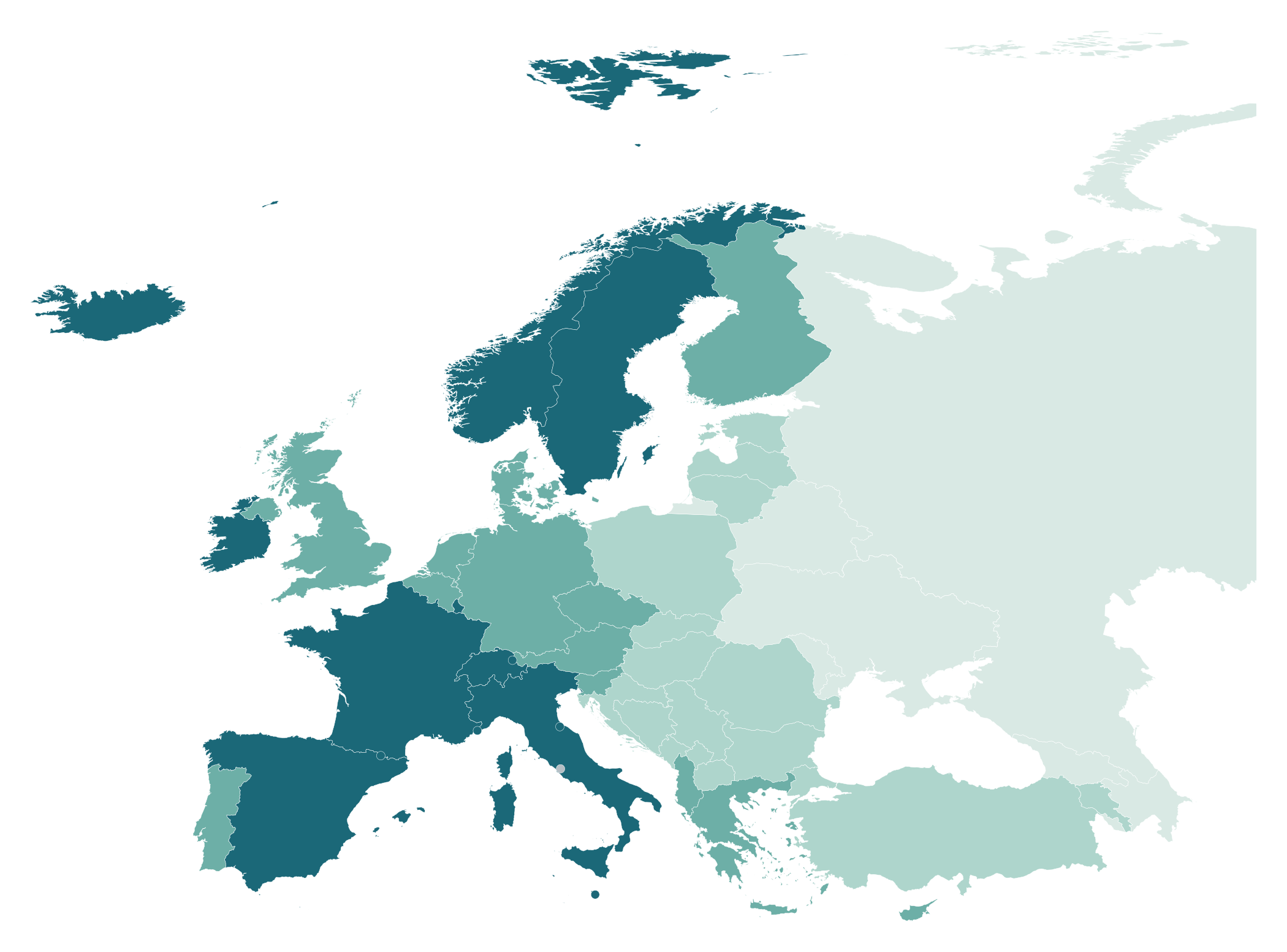
LIFE EXPECTANCY AT BIRTH

Total population · 2024

2024 World Bank SP.DYN.LE00.IN, total years at birth. Bands: ≤75, 76–79, 80–82, ≥83; no data where unavailable.

Do not substitute a regional average for missing national statistics.

Precise 2024 observations are rounded to the nearest whole year before classification; null or absent observations remain grey. The United Kingdom uses World Bank code GB and production ID UK.

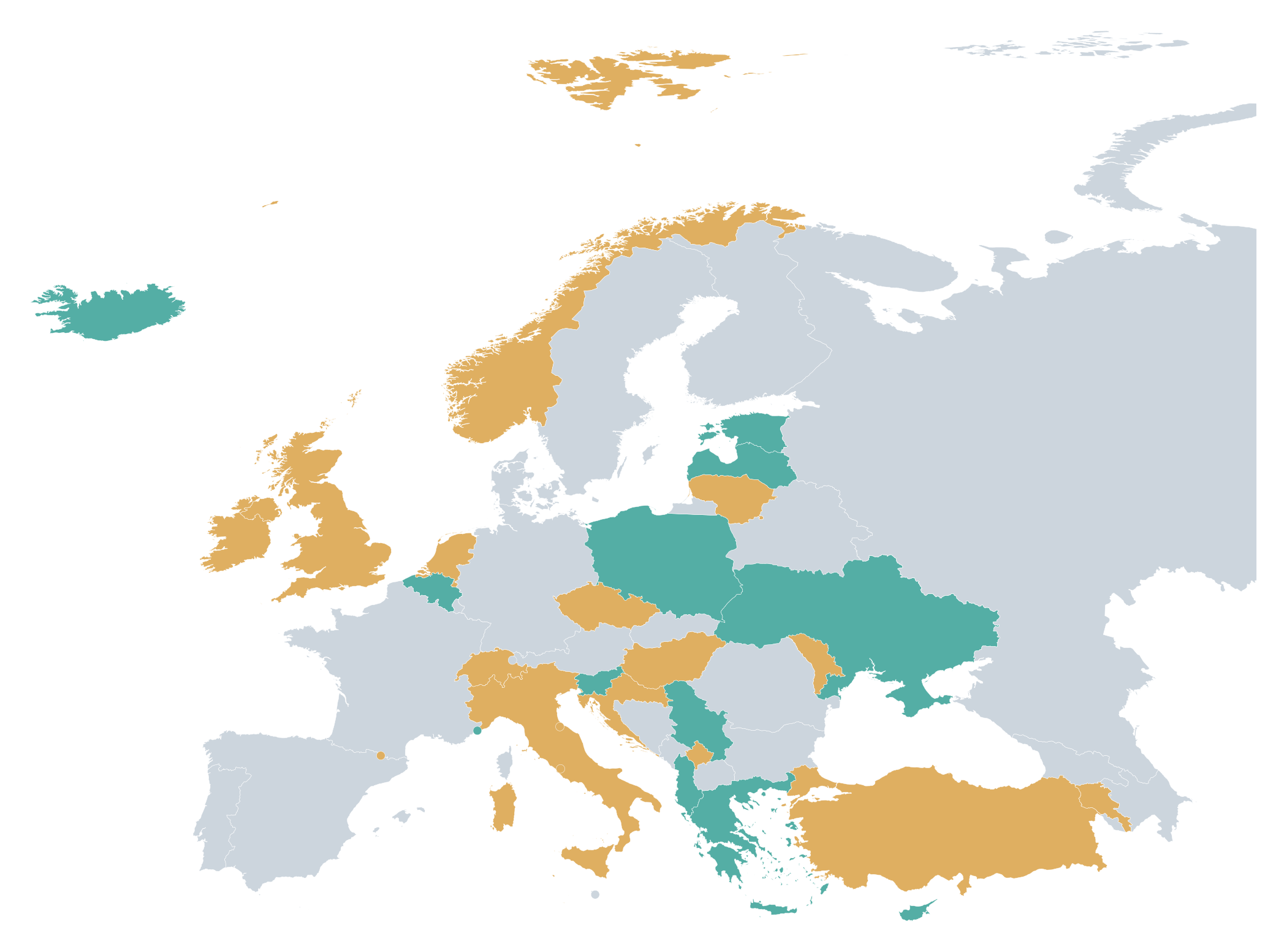
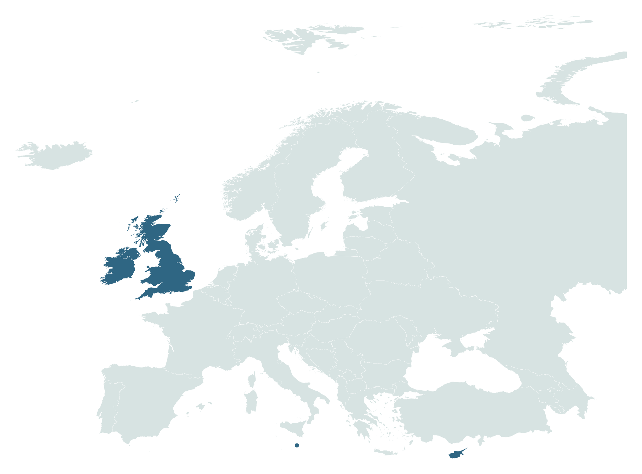
Driving side is a country-level comparison: United Kingdom, Ireland, Malta and Cyprus drive on the left. Associated territories may differ.

World Bank · SP.DYN.LE00.IN · 2024

UK Highway Code · Rule 160: keep to the left

EUROPE / MAP COVERAGE

Explore the Countries and Geographic Entities on This Map.

The Europe template covers 50 selectable map identities, including EU members, non-EU countries, microstates and some transcontinental entities.

MAP COVERAGE

50 selectable geographic identities

Color European countries from Iceland and Ireland to Türkiye, Cyprus and the Caucasus.

Kosovo is represented separately; geographic definitions of Europe and state recognition can vary.

WHAT THIS MAP INCLUDES

EU members
27
Non-EU identities
23
Selectable identities
50
Scope
Production Europe template

MapSculpt · Original Europe production geometry

EUROPE / SELECTABLE MAP IDENTITIES

Countries and Geographic Entities Included in the Europe Map

All 50 selectable country-level identities in MapSculpt’s Europe template. Some are transcontinental or have disputed status; the list is a template inventory, not a universal count of sovereign European states.

  • Andorra · ADNeither
  • Albania · ALNATO only
  • Armenia · AMNeither
  • Austria · ATEU only
  • Azerbaijan · AZNeither
  • Bosnia and Herzegovina · BANeither
  • Belgium · BEEU + NATO
  • Bulgaria · BGEU + NATO
  • Belarus · BYNeither
  • Switzerland · CHNeither
  • Cyprus · CYEU only
  • Czechia · CZEU + NATO
  • Germany · DEEU + NATO
  • Denmark · DKEU + NATO
  • Estonia · EEEU + NATO
  • Spain · ESEU + NATO
  • Finland · FIEU + NATO
  • France · FREU + NATO
  • Georgia · GENeither
  • Greece · GREU + NATO
  • Croatia · HREU + NATO
  • Hungary · HUEU + NATO
  • Ireland · IEEU only
  • Iceland · ISNATO only
  • Italy · ITEU + NATO
  • Liechtenstein · LINeither
  • Lithuania · LTEU + NATO
  • Luxembourg · LUEU + NATO
  • Latvia · LVEU + NATO
  • Monaco · MCNeither
  • Republic of Moldova · MDNeither
  • Montenegro · MENATO only
  • North Macedonia · MKNATO only
  • Malta · MTEU only
  • Netherlands (Kingdom of the) · NLEU + NATO
  • Norway · NONATO only
  • Poland · PLEU + NATO
  • Portugal · PTEU + NATO
  • Romania · ROEU + NATO
  • Serbia · RSNeither
  • Russian Federation · RUNeither
  • Sweden · SEEU + NATO
  • Slovenia · SIEU + NATO
  • Slovakia · SKEU + NATO
  • San Marino · SMNeither
  • Türkiye · TRNATO only
  • Ukraine · UANeither
  • United Kingdom of Great Britain and Northern Ireland · UKNATO only
  • Holy See · VANeither
  • Kosovo · XKNeither

Internal codes UK and XK follow MapSculpt conventions. Country status, geographic boundaries and European inclusion are not universally defined.

FREQUENTLY ASKED QUESTIONS

Frequently Asked Questions About Europe Maps

How can I color countries on a map of Europe?

Open the Europe editor, select and color individual countries, add a legend and title, then download a PNG.

How many countries are included in MapSculpt's Europe map?

MapSculpt has 50 selectable European country-level identities, including Kosovo and transcontinental countries. This is not a universally agreed sovereign-state total.

What's the difference between a Europe map and an EU countries map?

The European Union is a political union of 27 countries. Geographical Europe also includes Norway, Switzerland, the United Kingdom and many other non-EU countries.

Can I create a European statistical or choropleth map?

Yes. Color countries by verified indicators such as World Bank life expectancy, and include the reference year, classification and source.

Can I make a map of European countries I've visited?

Yes. Color visited, want-to-visit and not-yet-visited countries; this is a manual illustrative workflow, not automated travel-history import.

Can I create maps for r/MapPorn, r/dataisbeautiful and r/europe?

Yes. Create maps for r/MapPorn, r/dataisbeautiful, r/europe and other communities using, for example, Eurostat data or other official sources. Check subreddit posting rules.

Can I create a custom Europe map online for free?

Yes. MapSculpt is free for manual coloring, categories, legends and PNG export.

Can I download a customized Europe map as a PNG?

Yes. Export a high-resolution PNG with a clear title, legend and source. Check image readability and any community-specific posting requirements.

READY TO CREATE YOUR MAP?

Create Your Own Map of Europe.

Color European countries, customize your legend and download a professional-looking PNG map.

Create My Europe Map