Skip to content
MapSculpt

GEOGRAPHIC MAP MAKER / MINNESOTA

Minnesota
Counties Map Maker

Trace relative population growth near the Twin Cities and compare it with changes around Minnesota’s northern lakes and western counties. Use the same 87 county features for your own map.

Free online editor · No sign-up required

87counties
individually editable

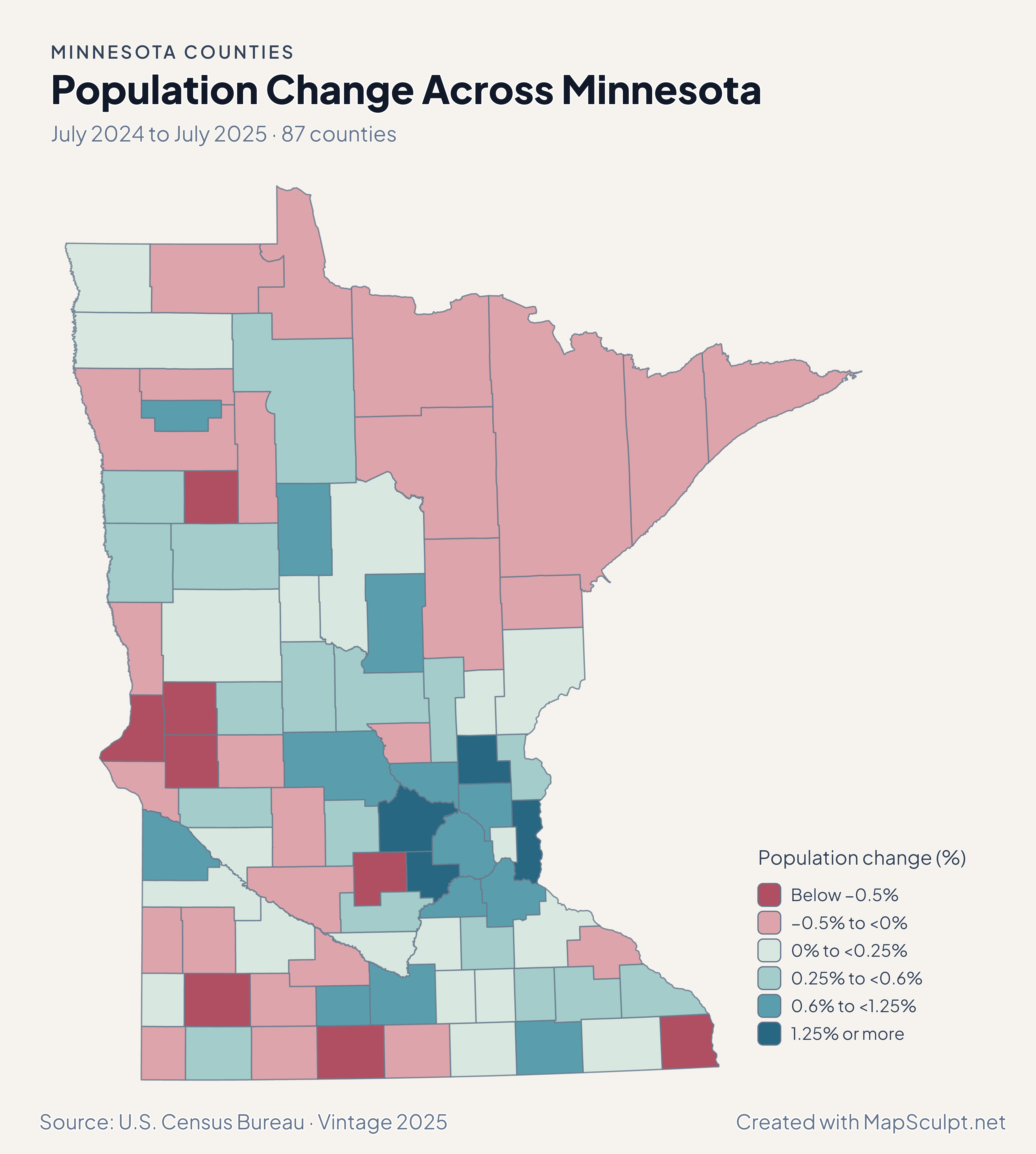
Population Change Across Minnesota

July 2024 to July 2025 · 87 counties

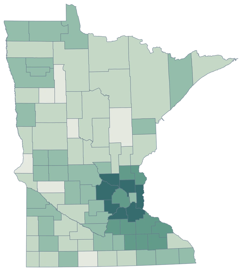
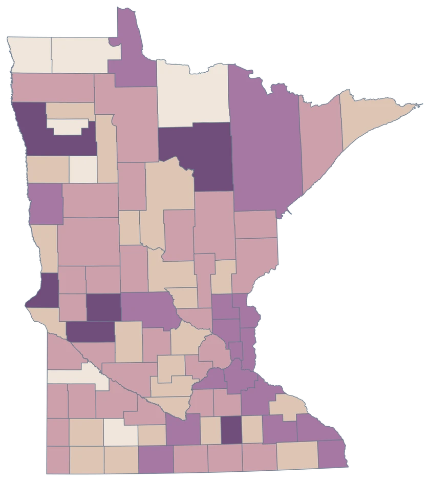
Minnesota population change with strong growth in Wright and Isanti and small decline in Lake of the Woods.

Population change (%)

  • Below −0.5%
  • −0.5% to <0%
  • 0% to <0.25%
  • 0.25% to <0.6%
  • 0.6% to <1.25%
  • 1.25% or more
U.S. Census Bureau · Vintage 2025Download complete PNG The growth map divides each county’s change by its own July 2024 population, which makes percentages comparable across different population sizes.

KNOW YOUR GEOGRAPHY

Twin Cities counties and the northern lake boundary.

The outline includes Minnesota’s irregular northern border and the Lake of the Woods county geography retained in the 2025 Census source. Separate pieces of a county use one identifier.

Minneapolis and St. Paul are within Hennepin and Ramsey counties respectively. The editor uses the full county boundaries. Compare consistent geographic units before joining city or metropolitan data.

Browse all county GEOIDs ↗

2025 Census boundaries

OFFICIAL DATA

Look beyond the Twin Cities core.

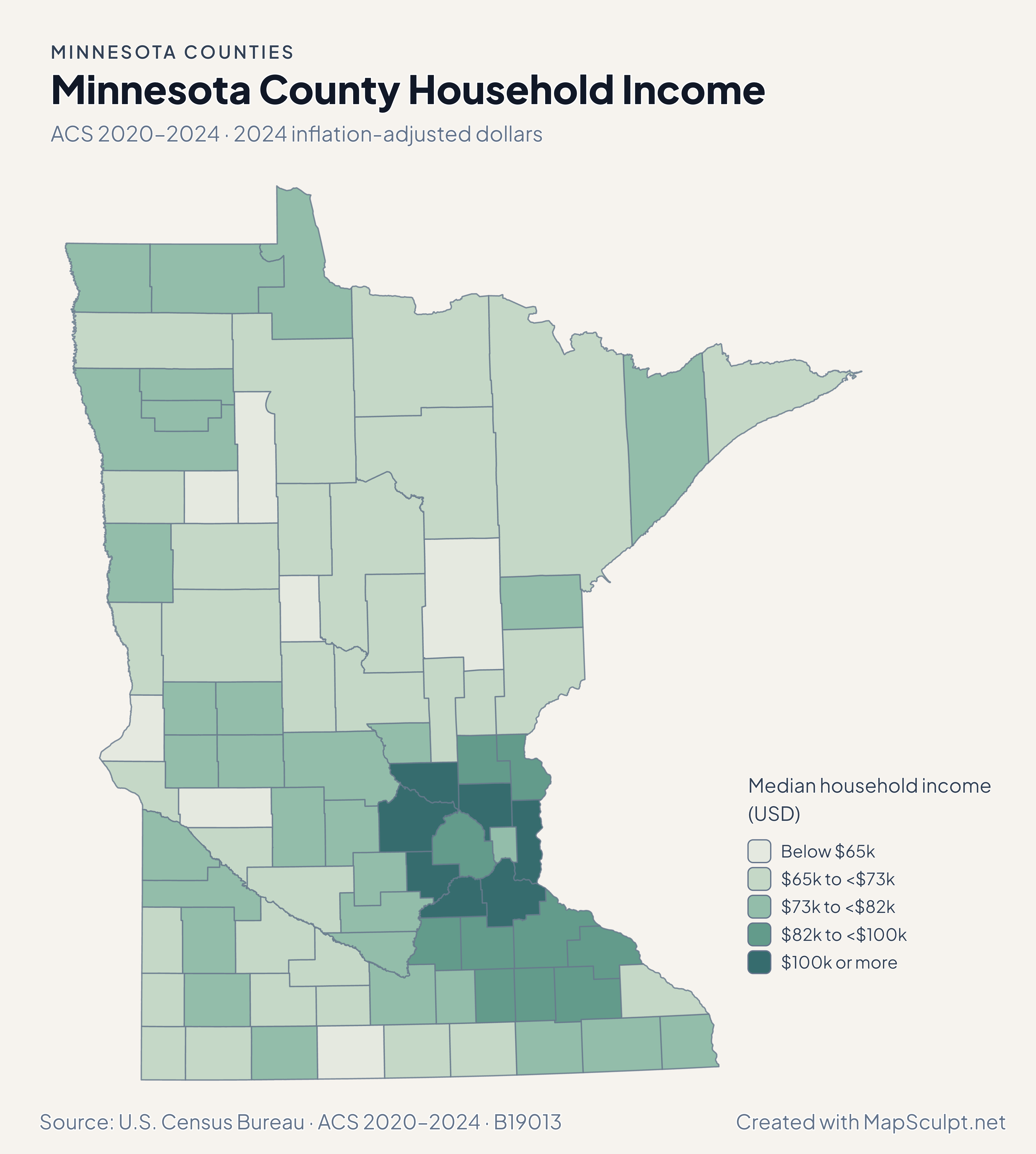
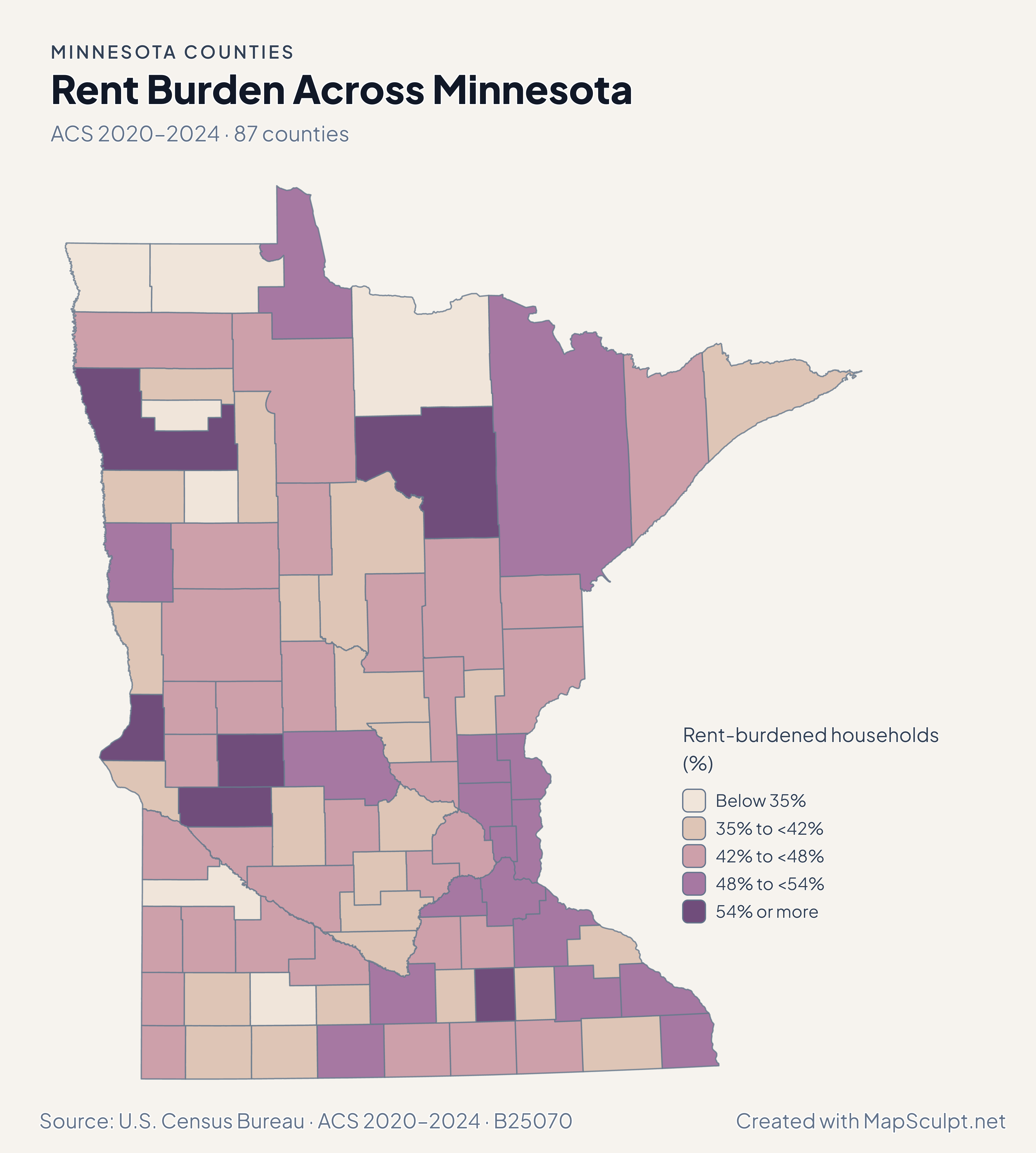
Population change and domestic migration show different aspects of the same year. Use the household income and rent maps for separate ACS comparisons.

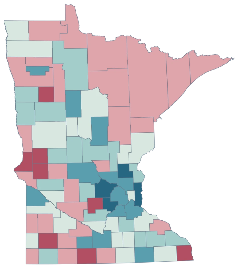
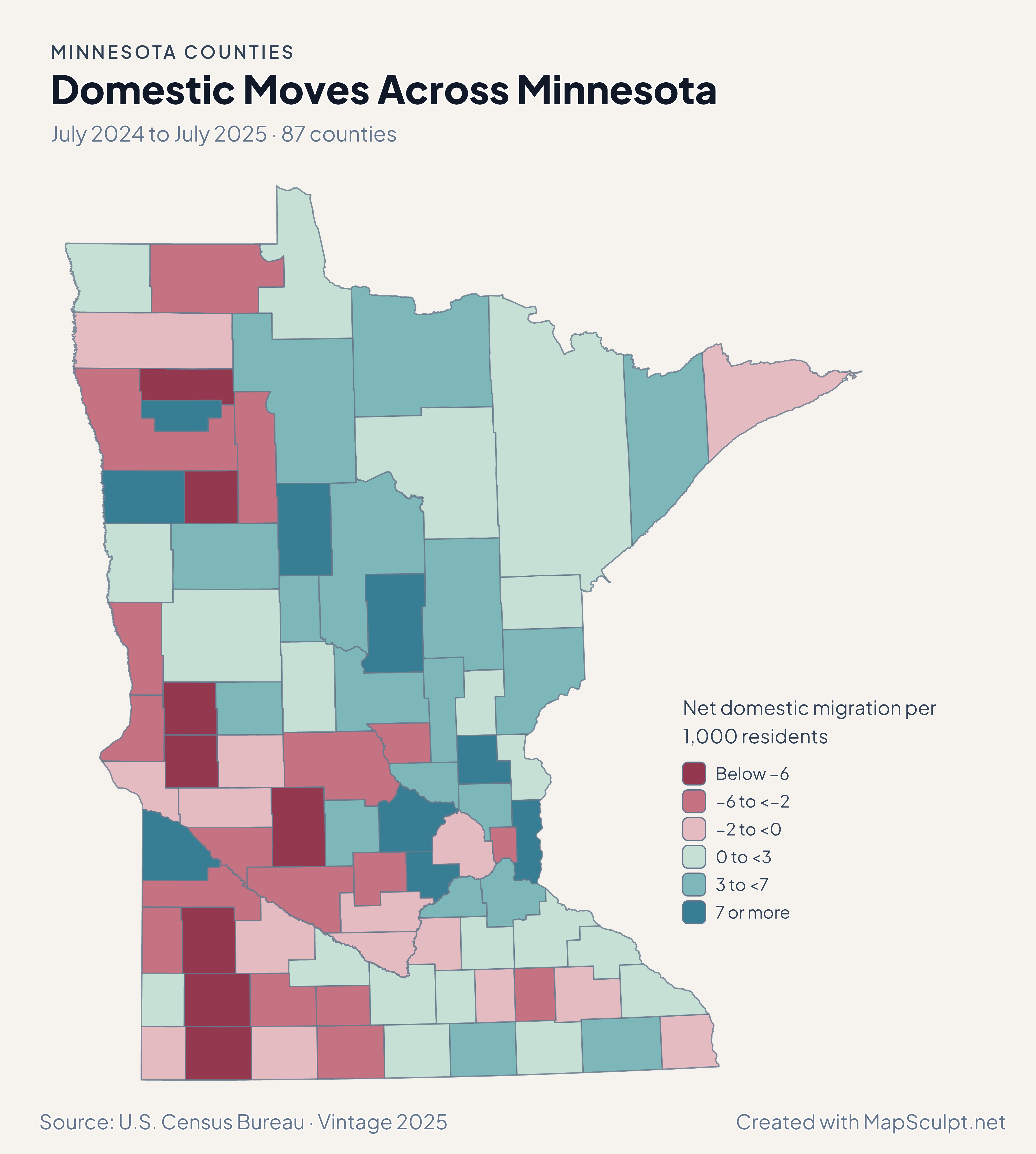
Minnesota domestic migration with Hubbard in a high-gain band and Hennepin and Ramsey in loss bands.

July 2024 to July 2025 · 87 counties

Northern migration gains and metro losses can coexist.

Hubbard recorded 13.22 net domestic movers per 1,000 residents, while Ramsey recorded −5.40 and Hennepin −0.55. Both metro counties still grew overall.

Net domestic migration per 1,000 residents

  • Below −6
  • −6 to <−2
  • −2 to <0
  • 0 to <3
  • 3 to <7
  • 7 or more

U.S. Census Bureau · Vintage 2025

Download complete PNG

Wright led county percentage growth at 1.91%. Isanti grew 1.67%, while Hennepin gained 0.60% and Ramsey gained 0.17%. In the north, Lake of the Woods declined 0.26%. See the Census estimates ↗

MAKE IT YOURS

From county data to a finished map.

  1. Choose the editor

    Use the Minnesota editor to map the Twin Cities counties and the rest of the state in one view.

  2. Match the county rows

    Use county-wide totals and five-digit GEOIDs. For example, Hennepin uses 27053 and Ramsey uses 27123.

  3. Write the legend

    If you calculate population growth yourself, divide the change by each county’s starting population. Put the percent unit on the legend.

  4. Export the map

    Inspect the Lake of the Woods outline in the export preview and leave space around the northern tip.

TRY CSV IMPORT

Practice a six-county join in Minnesota.

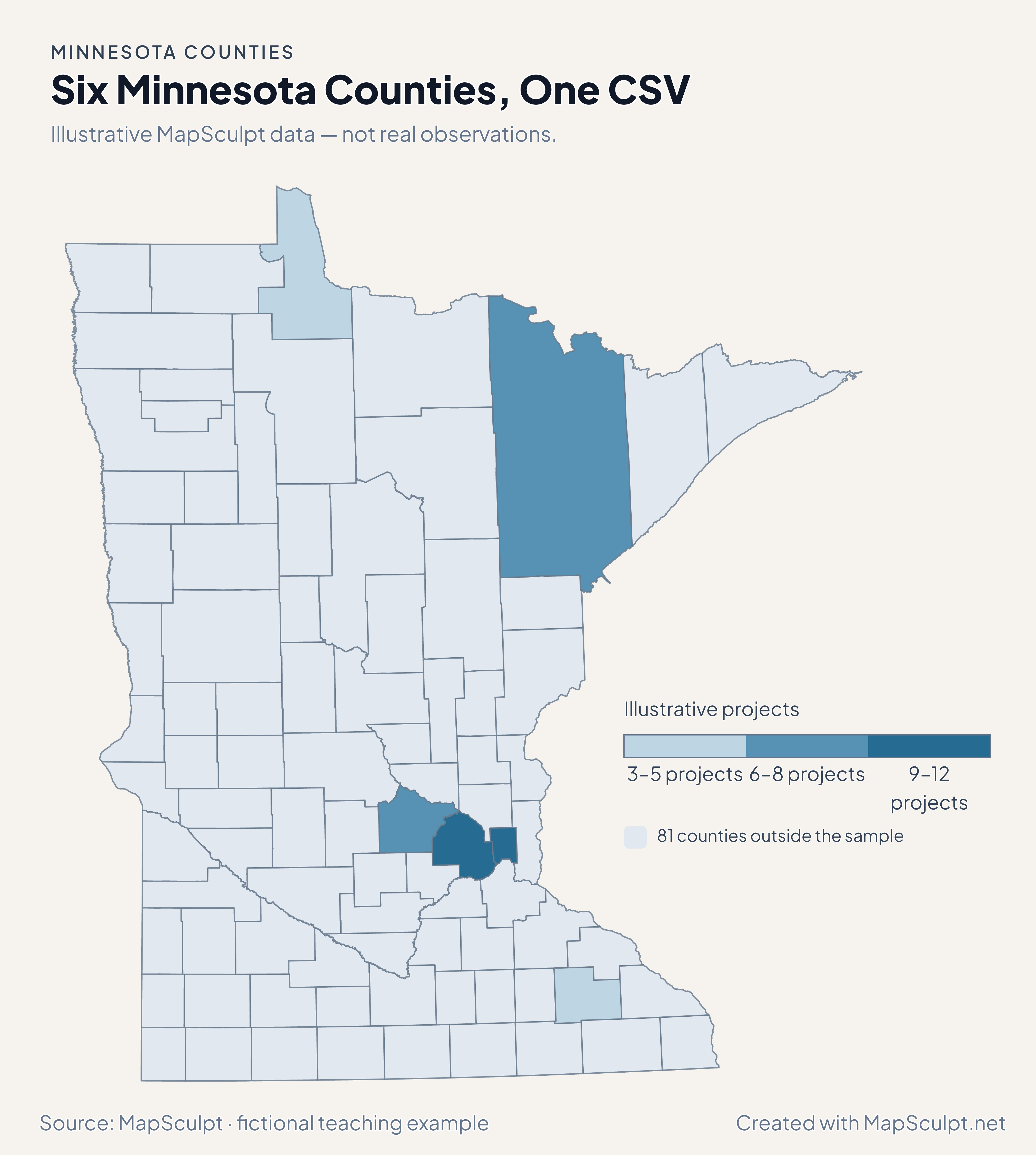
Import the fictional project counts, choose IllustrativeProjects, and set numeric boundaries of 3, 6, 9 and 12. The other 81 counties remain neutral.

Illustrative MapSculpt data — not real observations.
CountyGEOIDProjects
Hennepin County2705312
Ramsey County271239
Wright County271718
St. Louis County271376
Lake of the Woods County270773
Olmsted County271095

Keep GEOIDs as text. The sample matches Hennepin County with 27053. Check the directory for official names and codes before importing your data.

Download illustrative CSV ↓

Six Minnesota Counties, One CSV

Illustrative MapSculpt data — not real observations.

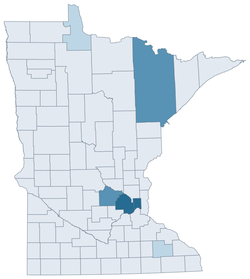
Fictional project counts across six Minnesota counties. The other 81 counties are neutral.

Illustrative projects

  • 3–5 projects
  • 6–8 projects
  • 9–12 projects
  • 81 counties outside the sample
Download complete PNG

CSV → Match 6 counties → Style → Export PNG Create a Minnesota map

COUNTY REFERENCE

Find all 87 Minnesota county GEOIDs.

Official county names and five-digit Census GEOIDs. Search by name or code.

  1. Aitkin CountyGEOID 27001
  2. Anoka CountyGEOID 27003
  3. Becker CountyGEOID 27005
  4. Beltrami CountyGEOID 27007
  5. Benton CountyGEOID 27009
  6. Big Stone CountyGEOID 27011
  7. Blue Earth CountyGEOID 27013
  8. Brown CountyGEOID 27015
  9. Carlton CountyGEOID 27017
  10. Carver CountyGEOID 27019
  11. Cass CountyGEOID 27021
  12. Chippewa CountyGEOID 27023
  13. Chisago CountyGEOID 27025
  14. Clay CountyGEOID 27027
  15. Clearwater CountyGEOID 27029
  16. Cook CountyGEOID 27031
  17. Cottonwood CountyGEOID 27033
  18. Crow Wing CountyGEOID 27035
  19. Dakota CountyGEOID 27037
  20. Dodge CountyGEOID 27039
  21. Douglas CountyGEOID 27041
  22. Faribault CountyGEOID 27043
  23. Fillmore CountyGEOID 27045
  24. Freeborn CountyGEOID 27047
  25. Goodhue CountyGEOID 27049
  26. Grant CountyGEOID 27051
  27. Hennepin CountyGEOID 27053
  28. Houston CountyGEOID 27055
  29. Hubbard CountyGEOID 27057
  30. Isanti CountyGEOID 27059
  31. Itasca CountyGEOID 27061
  32. Jackson CountyGEOID 27063
  33. Kanabec CountyGEOID 27065
  34. Kandiyohi CountyGEOID 27067
  35. Kittson CountyGEOID 27069
  36. Koochiching CountyGEOID 27071
  37. Lac qui Parle CountyGEOID 27073
  38. Lake CountyGEOID 27075
  39. Lake of the Woods CountyGEOID 27077
  40. Le Sueur CountyGEOID 27079
  41. Lincoln CountyGEOID 27081
  42. Lyon CountyGEOID 27083
  43. Mahnomen CountyGEOID 27087
  44. Marshall CountyGEOID 27089
  45. Martin CountyGEOID 27091
  46. McLeod CountyGEOID 27085
  47. Meeker CountyGEOID 27093
  48. Mille Lacs CountyGEOID 27095
  49. Morrison CountyGEOID 27097
  50. Mower CountyGEOID 27099
  51. Murray CountyGEOID 27101
  52. Nicollet CountyGEOID 27103
  53. Nobles CountyGEOID 27105
  54. Norman CountyGEOID 27107
  55. Olmsted CountyGEOID 27109
  56. Otter Tail CountyGEOID 27111
  57. Pennington CountyGEOID 27113
  58. Pine CountyGEOID 27115
  59. Pipestone CountyGEOID 27117
  60. Polk CountyGEOID 27119
  61. Pope CountyGEOID 27121
  62. Ramsey CountyGEOID 27123
  63. Red Lake CountyGEOID 27125
  64. Redwood CountyGEOID 27127
  65. Renville CountyGEOID 27129
  66. Rice CountyGEOID 27131
  67. Rock CountyGEOID 27133
  68. Roseau CountyGEOID 27135
  69. Scott CountyGEOID 27139
  70. Sherburne CountyGEOID 27141
  71. Sibley CountyGEOID 27143
  72. St. Louis CountyGEOID 27137
  73. Stearns CountyGEOID 27145
  74. Steele CountyGEOID 27147
  75. Stevens CountyGEOID 27149
  76. Swift CountyGEOID 27151
  77. Todd CountyGEOID 27153
  78. Traverse CountyGEOID 27155
  79. Wabasha CountyGEOID 27157
  80. Wadena CountyGEOID 27159
  81. Waseca CountyGEOID 27161
  82. Washington CountyGEOID 27163
  83. Watonwan CountyGEOID 27165
  84. Wilkin CountyGEOID 27167
  85. Winona CountyGEOID 27169
  86. Wright CountyGEOID 27171
  87. Yellow Medicine CountyGEOID 27173
U.S. Census Bureau · 2025 Cartographic Boundary Files

COMMON QUESTIONS

Minnesota county map questions.

Can I select Minneapolis and St. Paul on this map?

Use Hennepin and Ramsey for observations that cover those counties. The map does not select cities separately.

Which GEOID identifies Lake of the Woods County?

Use 27077 for county-wide values. The generalized shoreline and border retain the source’s county identity.

Can I color the Twin Cities region as one category?

Yes. Decide which whole counties your definition includes and give them a common group or color.

Why are Ramsey and Wright different on the growth map?

The map uses percentage change between the two July estimates. Wright had a larger relative increase than Ramsey.

How can I include counties across Lake Superior?

Use the national county editor if the project also covers Wisconsin or Michigan.

Can I join data named St. Louis?

Use 27137 for St. Louis County in Minnesota. The full GEOID distinguishes it from similarly named units in other states.

YOUR NEXT MAP STARTS HERE

Create a Minnesota county comparison.

Join official county identifiers to your values, choose a readable legend, and download your finished Minnesota map.

Create a Minnesota map