Skip to content
MapSculpt

GEOGRAPHIC MAP MAKER / AFRICA

Africa Map Maker — Create and Colour Your Own Map

Create a custom map of Africa online. Colour individual countries, compare data, import a CSV, customise your legend and export a high-resolution PNG.

Free to use · No sign-up required to create and export a map

57selectable countries and areas

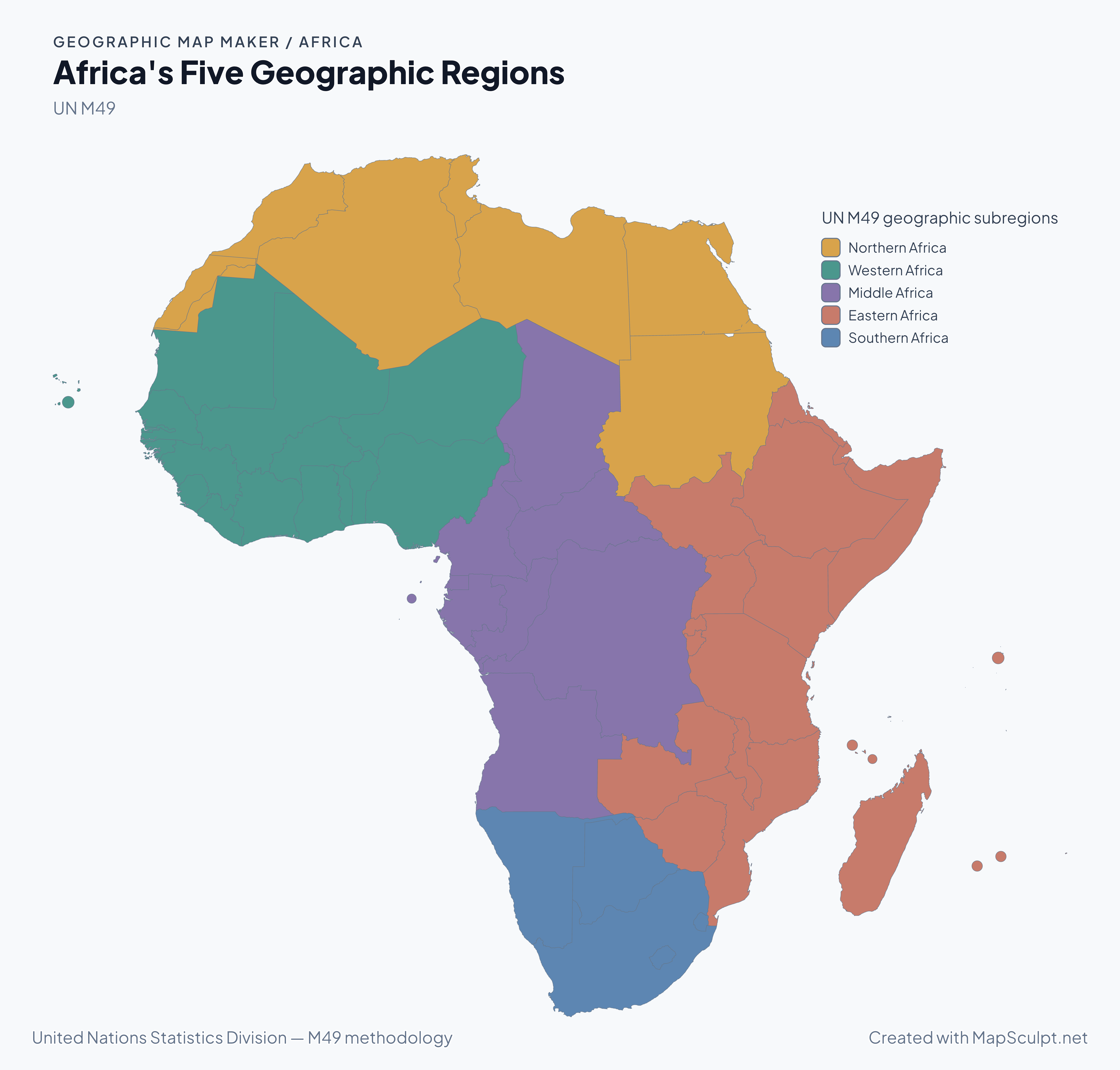
Africa's Five Geographic Regions

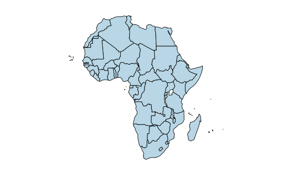
MapSculpt Africa map showing 57 areas in five categorical colours for Northern, Western, Middle, Eastern and Southern Africa.

UN M49 geographic subregions

  • Northern Africa
  • Western Africa
  • Middle Africa
  • Eastern Africa
  • Southern Africa

UN M49. Five categorical colours show the UN M49 geographic subregions, with every selectable area assigned to its official group. Colours identify regions; they do not represent a numerical ranking.

GEOGRAPHIC COVERAGE

54 countries. One continent. Countless stories.

Africa has 54 UN member states. MapSculpt includes all of them, plus Western Sahara, Réunion and Mayotte: 57 selectable identities in total. These additional areas are not independent UN member states. Western Sahara is a disputed territory; Réunion and Mayotte are French overseas departments.

The production equal-area map preserves its generalised coastlines and island parts. The optional Western Sahara boundary display changes how the boundary is drawn, not the area's selectable identity. Geographic groupings follow UN M49. United Nations Statistics Division — M49 methodology

Explore all 57 map areas

MAP EXAMPLES

Africa in four maps

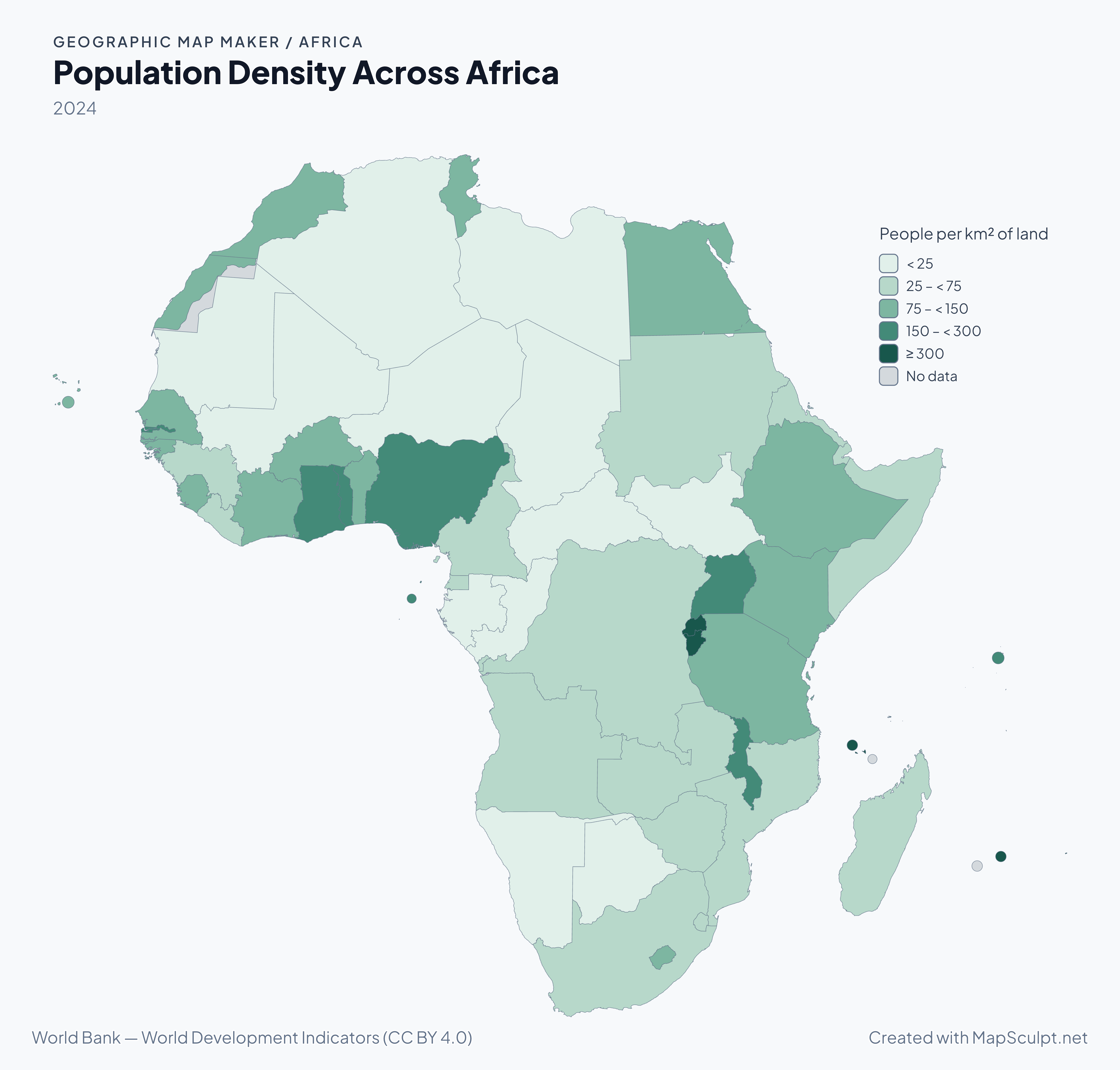
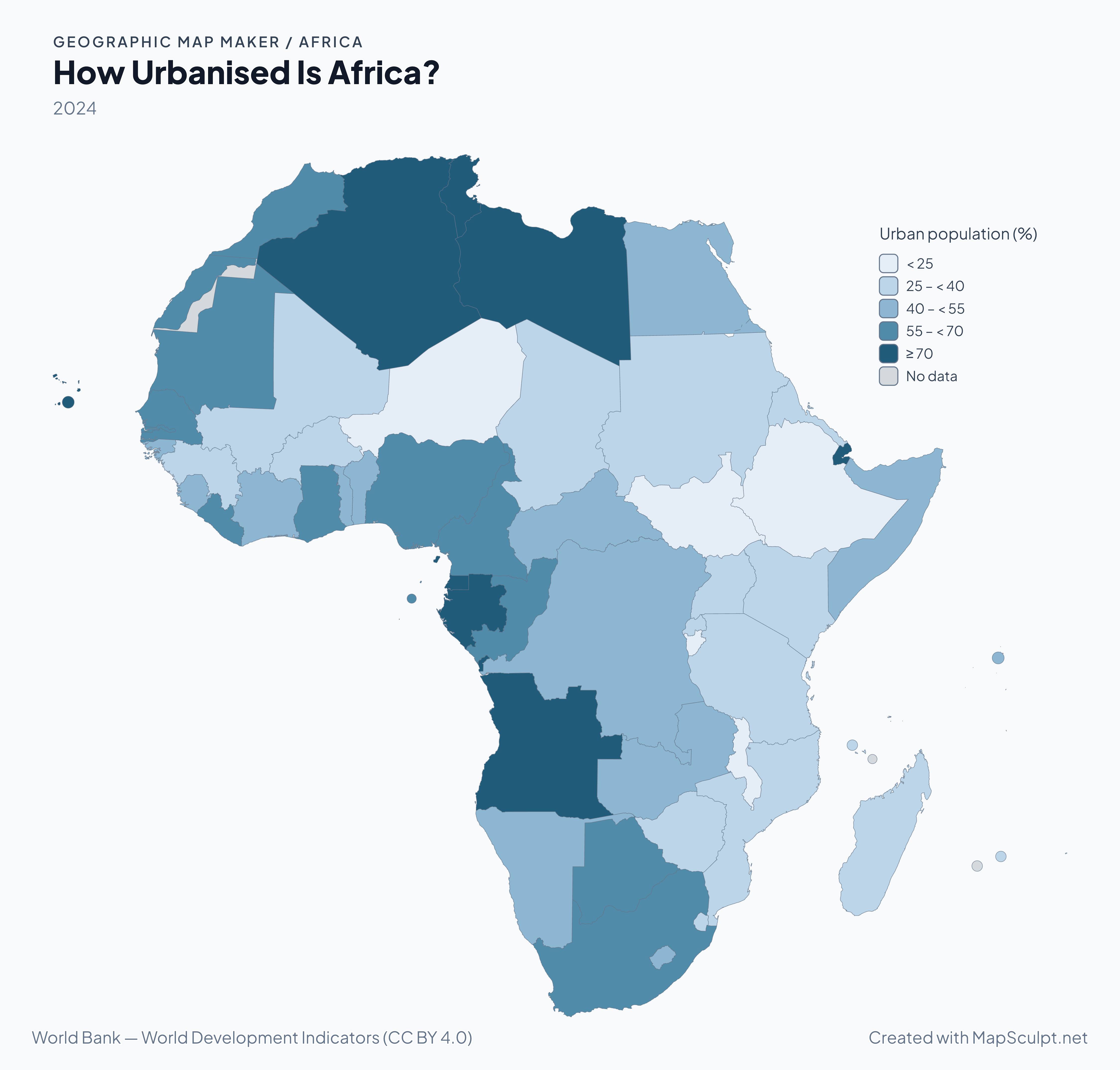
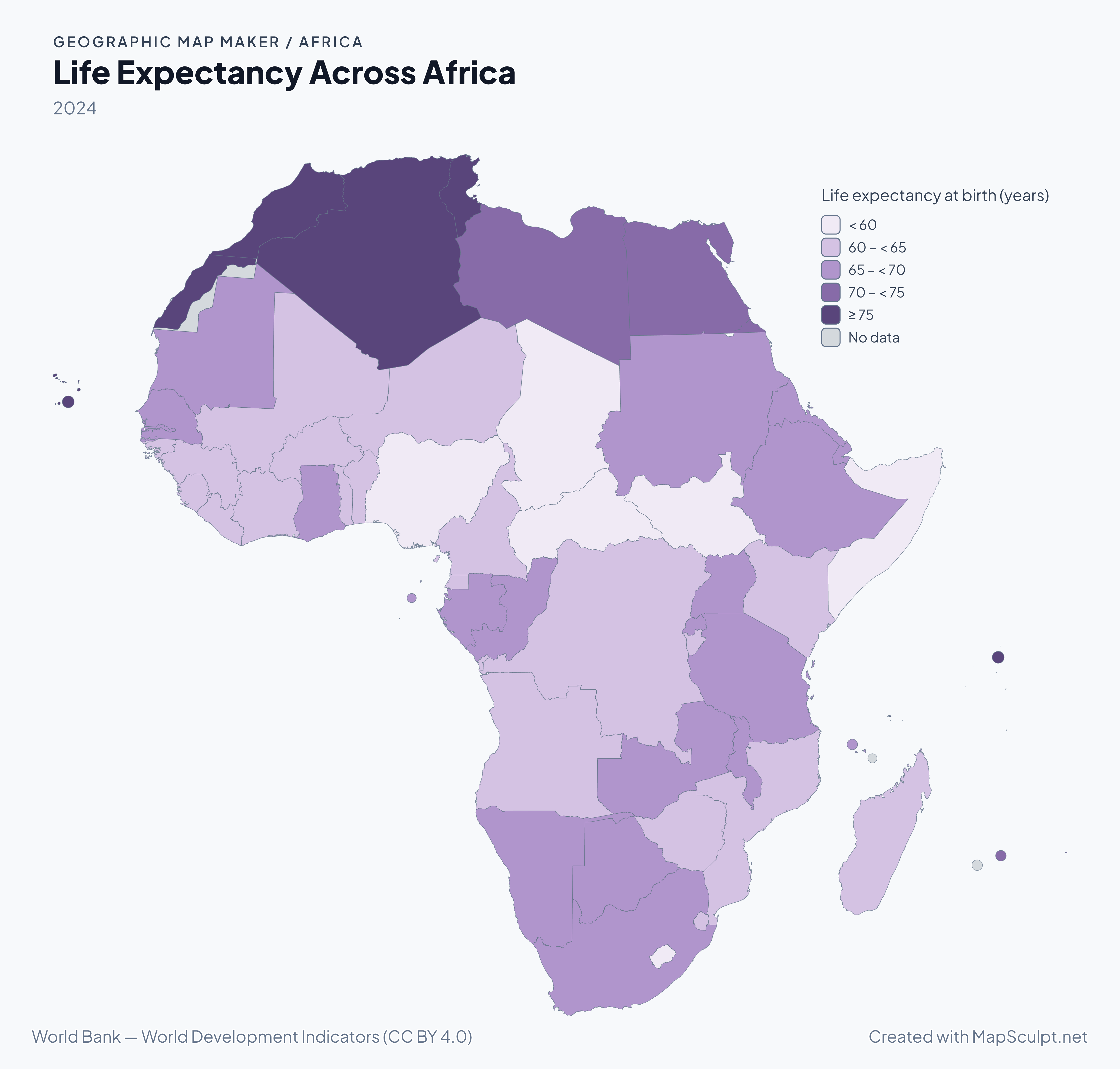
Start with the five-region reference map above, then compare three World Bank indicators. Each statistical map uses 2024 observations for 54 areas; Western Sahara, Réunion and Mayotte have no observations in this snapshot.

2024 population density map of Africa with five green classes and three areas shown as no data.

2024

Population Density Across Africa

A country average can hide dense cities and sparsely populated land. Mauritius reaches 622.9 people per square kilometre of land in this snapshot; wider bins keep lower-density countries distinguishable.

  • < 25
  • 25 – < 75
  • 75 – < 150
  • 150 – < 300
  • ≥ 300
  • No data

Population divided by land area, excluding inland water. These are country averages, not a settlement map. Missing values remain separate from zero.

World Bank — World Development Indicators (CC BY 4.0)

Download full-resolution PNGCreate your Africa map

HOW IT WORKS

From country data to a finished Africa map

  1. Choose your countries

    Open the Africa editor and colour individual countries or begin with a blank map.

  2. Import your CSV

    Match country names or ISO codes and apply categorical or numerical values.

  3. Customise your map

    Adjust palettes, borders, titles, annotations and legends.

  4. Export your PNG

    Select the format and resolution, then download the finished map.

CSV TO MAP

From spreadsheet to Africa travel map

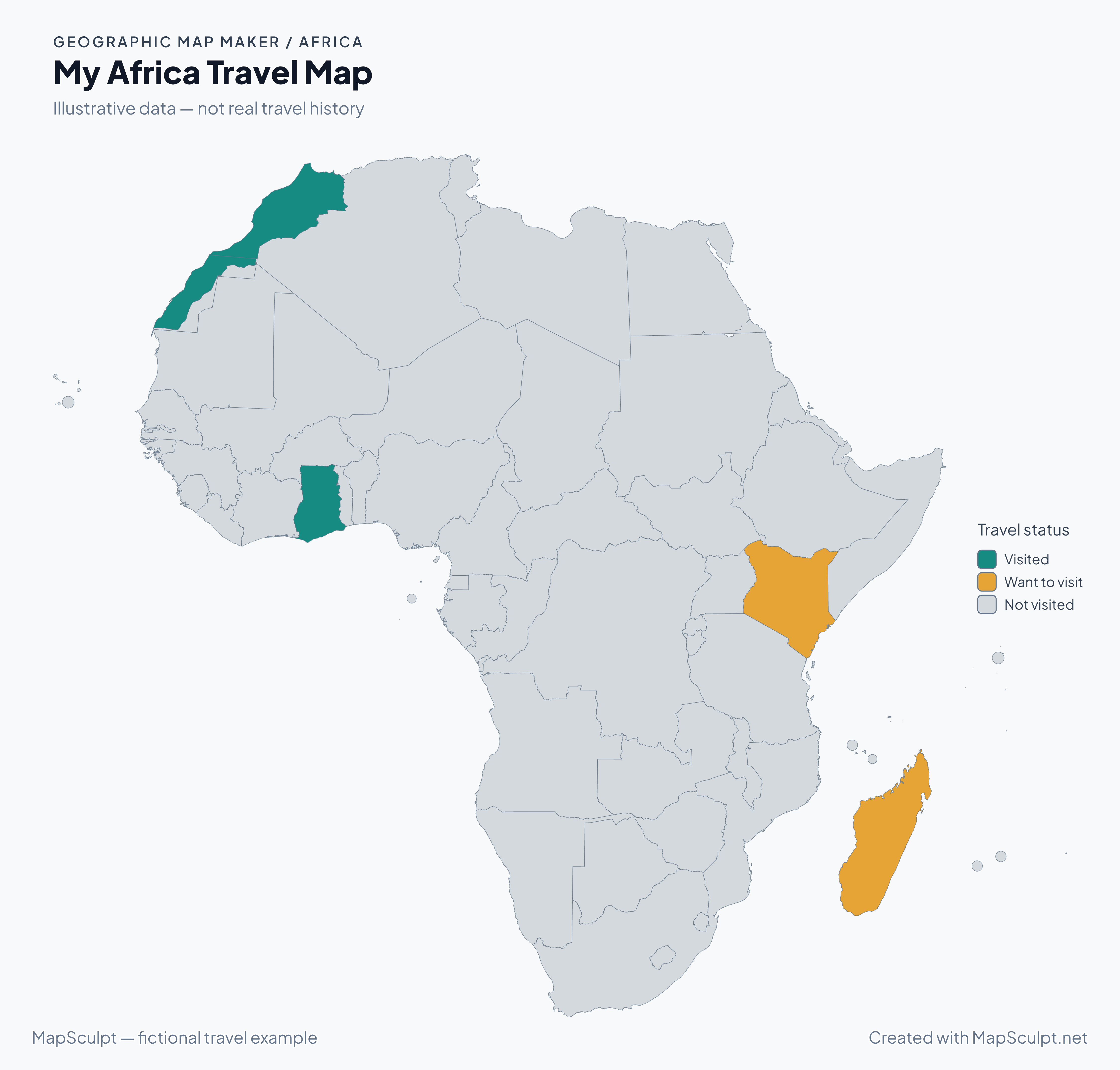
Map places you've visited, destinations on your bucket list and areas you haven't explored yet. Import a simple CSV and turn an itinerary into a colourful map.

Fictional travel example — five rows from the complete 57-area CSV
Country or areaISO2Status
MoroccoMAVisited
GhanaGHVisited
KenyaKEWant to visit
MadagascarMGWant to visit
AlgeriaDZNot visited

Illustrative MapSculpt data — not a person's travel history. Morocco and Ghana are Visited; Kenya and Madagascar are Want to visit; all other 53 areas are Not visited. The download contains all 57 ISO2 identifiers.

Download travel CSV

My Africa Travel Map

Fictional Africa travel map: Morocco and Ghana visited, Kenya and Madagascar on the wish list, and all other areas not visited.
  • Visited
  • Want to visit
  • Not visited
Create your Africa travel mapDownload full-resolution PNGExplore Travel Map Maker

COUNTRY AND AREA DIRECTORY

Africa's 57 Selectable Areas

Find countries and areas by localised or official name, ISO2/ISO3 code, recognised alias or UN geographic subregion. The list uses the editor's exact identities.

  1. DZ
    AlgeriaNorthern AfricaUN member state
  2. AO
    AngolaMiddle AfricaUN member state
  3. BJ
    BeninWestern AfricaUN member state
  4. BW
    BotswanaSouthern AfricaUN member state
  5. BF
    Burkina FasoWestern AfricaUN member state
  6. BI
    BurundiEastern AfricaUN member state
  7. CM
    CameroonMiddle AfricaUN member state
  8. CV
    Cape VerdeWestern AfricaUN member state
  9. CF
    Central African RepublicMiddle AfricaUN member state
  10. TD
    ChadMiddle AfricaUN member state
  11. KM
    ComorosEastern AfricaUN member state
  12. CG
    Congo - BrazzavilleMiddle AfricaUN member state
  13. CI
    Côte d’IvoireWestern AfricaUN member state
  14. CD
    Democratic Republic of the CongoMiddle AfricaUN member state
  15. DJ
    DjiboutiEastern AfricaUN member state
  16. EG
    EgyptNorthern AfricaUN member state
  17. GQ
    Equatorial GuineaMiddle AfricaUN member state
  18. ER
    EritreaEastern AfricaUN member state
  19. SZ
    EswatiniSouthern AfricaUN member state
  20. ET
    EthiopiaEastern AfricaUN member state
  21. GA
    GabonMiddle AfricaUN member state
  22. GM
    GambiaWestern AfricaUN member state
  23. GH
    GhanaWestern AfricaUN member state
  24. GN
    GuineaWestern AfricaUN member state
  25. GW
    Guinea-BissauWestern AfricaUN member state
  26. KE
    KenyaEastern AfricaUN member state
  27. LS
    LesothoSouthern AfricaUN member state
  28. LR
    LiberiaWestern AfricaUN member state
  29. LY
    LibyaNorthern AfricaUN member state
  30. MG
    MadagascarEastern AfricaUN member state
  31. MW
    MalawiEastern AfricaUN member state
  32. ML
    MaliWestern AfricaUN member state
  33. MR
    MauritaniaWestern AfricaUN member state
  34. MU
    MauritiusEastern AfricaUN member state
  35. YT
    MayotteEastern AfricaFrench overseas department
  36. MA
    MoroccoNorthern AfricaUN member state
  37. MZ
    MozambiqueEastern AfricaUN member state
  38. NA
    NamibiaSouthern AfricaUN member state
  39. NE
    NigerWestern AfricaUN member state
  40. NG
    NigeriaWestern AfricaUN member state
  41. RE
    RéunionEastern AfricaFrench overseas department
  42. RW
    RwandaEastern AfricaUN member state
  43. ST
    São Tomé & PríncipeMiddle AfricaUN member state
  44. SN
    SenegalWestern AfricaUN member state
  45. SC
    SeychellesEastern AfricaUN member state
  46. SL
    Sierra LeoneWestern AfricaUN member state
  47. SO
    SomaliaEastern AfricaUN member state
  48. ZA
    South AfricaSouthern AfricaUN member state
  49. SS
    South SudanEastern AfricaUN member state
  50. SD
    SudanNorthern AfricaUN member state
  51. TZ
    TanzaniaEastern AfricaUN member state
  52. TG
    TogoWestern AfricaUN member state
  53. TN
    TunisiaNorthern AfricaUN member state
  54. UG
    UgandaEastern AfricaUN member state
  55. EH
    Western SaharaNorthern AfricaDisputed territory
  56. ZM
    ZambiaEastern AfricaUN member state
  57. ZW
    ZimbabweEastern AfricaUN member state

United Nations Statistics Division — M49 methodology

How Is Africa Divided into Geographic Regions?

UN M49 groups Africa into Northern Africa and Sub-Saharan Africa. The latter comprises Western, Middle, Eastern and Southern Africa. These statistical geographic groups can differ from the memberships used by political or economic organisations.

The editor's 57 areas are a selectable map inventory, not a count of sovereign states. Western Sahara remains a separate identity when its optional boundary display is changed. This map does not express a position on sovereignty.

United Nations Statistics Division — M49 methodology

THE MAPSCULPT COLLECTION

Choose your map.

Find your geography. Add your perspective.

98 maps / 8 collections

Countries, regions and counties. Ready for your ideas.

Sort maps

California

Counties

Texas

Counties

Florida

Counties

New York

Counties

Pennsylvania

Counties

Illinois

Counties

Ohio

Counties

Georgia

Counties

North Carolina

Counties

Michigan

Counties

New Jersey

Counties

Virginia

Counties

1–12 of 50 state maps
COMMON QUESTIONS

Africa map maker FAQ

How many countries are in Africa?

Africa has 54 UN member states. Geographic datasets may also include territories or other areas, so check what a count describes.

Why does MapSculpt have 57 selectable areas?

The editor includes the 54 UN member states plus Western Sahara, Réunion and Mayotte. These three additional identities are not counted as independent UN member states.

Can I make a blank Africa map?

Yes. Open the normal Africa editor and start with its uncoloured geography. You can adjust borders and choose which titles and legends to include in your PNG.

Can I colour individual African countries?

Yes. Each of the 57 countries or areas has its own selectable identity. Multipart islands belonging to an area share the same assignment.

Can I make a map of African countries I've visited?

Yes. The Africa travel preset starts every area as Not visited. Use Visited and Want to visit to record your own choices. It does not automatically track trips.

Can I import African country data from CSV?

Yes. Import a CSV with one geographic identifier per row and a category or numeric value. Review matching and classification before applying the map.

Can I use ISO country codes?

Yes. The importer recognises the supported ISO alpha-2 and alpha-3 identifiers. The sample uses ISO2 codes, including EH, RE and YT for the three additional areas.

Are Madagascar and smaller African islands included?

Yes. Madagascar, Cabo Verde, Comoros, Mauritius, Seychelles, Réunion, Mayotte and São Tomé and Príncipe are included. Generalised outlines and very small parts may need a high-resolution export to inspect.

How is Western Sahara displayed?

Western Sahara is a disputed territory with its own selectable identity. The editor offers an optional boundary display; changing that display does not merge or remove the area.

Can I export a high-resolution PNG?

Yes. Choose the export format and resolution in the editor. The full PNG links here download the genuine MapSculpt examples with titles, legends and sources.

Is MapSculpt free to use?

Yes. You can create, customise and export these maps for free without signing up. The travel example is fictional and can be replaced with your own data.

YOUR NEXT MAP

Make Africa's geography your own.

Start with 57 editable countries and areas. Add your colours, data and ideas, then export a map worth sharing.

Create your Africa map